The ancient town can be visited
Ancient BuildingBet Guvrin (בית גוברין)
Ancient Town Marissa (תל מראשה)
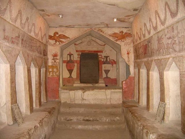
The ancient city of Marissa, today known as Tell Sandahannah, was a settlement in modern-day Israel.
History+
Marissa's origins stretch back far. As early as the 14th century BC, the Canaanite site of Maresha was mentioned in the Amarna letters. Around 920 BC, Solomon's son Rehoboam had the settlement fortified, but in 587 BC, it fell victim to the Babylonians. After the Babylonian captivity, Maresha was settled by Edomites and made their capital; later, Phoenicians also settled there. Under the Diadochi, the site underwent Hellenization and became the main city of the Idumaeans under the name Marissa. From 312 BC onwards, the city changed hands multiple times between Seleucid and Ptolemaic rule until it was completely destroyed by the Parthians in 40 BC and never rebuilt thereafter. The families of the Jewish King Herod and his brother-in-law Kostobaros are said to have originated from Marissa. Between 1898 and 1900, the inner city was extensively excavated, and further archaeological work continues to this day.
Location+
The ruins of the ancient city of Marissa are located in Bet Guvrin in the Southern District of Israel, at an elevation of approximately 345 m above sea level.
On site+
The inner city, measuring 150 x 160 meters and once surrounded by a wall, displays a grid-like layout with an east-west main street and smaller side streets. Surrounding the inner city is the so-called lower city, whose houses were often built over caves, some of which served as oil presses or columbaria. Outside the city, there is a necropolis with partially decorated tomb complexes.
Take Mobile History with you
You are reading this text for free. Premium adds what matters on the road: descriptions read aloud, sites found through your camera, whole regions taken offline.
- Every description, including the ~17,700 Premium sites
- Audio guide: have descriptions read to you on location
- AR finder: see sites through your camera, with distance and bearing
- Unlimited saved sites
14 days free, then from €2.99 a month. Cancel anytime.
Source: Wikipedia · Licence: CC BY-SA 4.0 · Image: http://en.wikipedia.org/wiki/File:Sidonian_Burial_Caves_036.jpg
This description draws on the facts documented in the linked Wikipedia article; Wikipedia content is licensed under CC BY-SA 4.0. Wording and editing: Mobile History.
Location: 31.5925, 34.8984