CastleJülich - Bourheim

Bourheim Castle
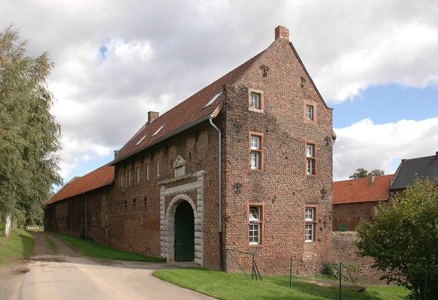
Bourheim Castle

To be privately owned

Bourheim Castle is a former moated castle in Bourheim, a district of Jülich, in the Düren district of North Rhine-Westphalia. It is protected as a building and archaeological monument. The complex is privately owned, inhabited, and not open to visitors.

As early as 1234, a farm in "Burnheim" was mentioned in a property register of Aemilius von O(u)we. This manor farm was an unfortified, agriculturally used complex, which was only later protected with strong walls against attackers. It was apparently a Cologne fief, as Heinrich von Bourheim fought on the side of the Cologne Archbishop Siegfried von Westerburg in the Battle of Worringen in 1288.

At the beginning of the 15th century, the estate was owned by Alart von Linzenich, and in 1478 by Loes von Linzenich. His family belonged to the vassals of the Dukes of Jülich. Through marriage, the castle passed in 1501 to Dietrich von Eys, also known as Beusdael (or Beusdahl). His family was followed in the 17th century by the von Friemersdorf zu Pützfeld family as owners, before the complex came to Aegidius von Haf(f)ten in 1665 through marriage. His daughter Anna brought it in the 18th century to the family of her second husband Wolfgang from the Wildenburg line of the Counts of Hatzfeld, before the property was bought in 1771 by the family of the Counts of Fürstenberg-Stammheim. During the Second World War, the castle was significantly damaged during the fighting on the Rur front. Today it is owned by the von Lünnick family.

Description+

Of the formerly two-part complex, only the brick outer bailey remains today. Of its manor house, only the ruin of a substructure with a barrel vault still exists.

The main building was a two-story structure on a rectangular floor plan, measuring approximately 12.5 × 9 meters, and dated from the 15th century. It stood on a motte-like hill, and its two narrow sides featured stepped gables. To save the remains of the rubble masonry from final collapse, they were encased with brick walls for stabilization in 1840. The moat that surrounded the building is still visible today.

North of the site of the former manor house is the three-winged farmyard on a U-shaped floor plan, which opens to the southwest towards the former main house and encloses an inner courtyard measuring approximately 60.5 × 32.5 meters. The single-story building wings with saddle roofs date from different centuries and are the successors of building tracts that were built from the inside against the medieval defensive walls of the estate. With the exception of the gatehouse, they only have windows and doors facing the secure inner courtyard. The outer side of the northwestern wing is about 73 meters long, while the southeastern part of the building measures about 55.5 meters on the outside. Wall anchors in the form of the year 1703 identify the northeastern, 46-meter-long tract of the outer bailey as buildings from the beginning of the 18th century. Older is the simple, 18.5 × 8 meter gatehouse of the complex at the southern end of the northwestern outer bailey wing. It was built around 1600 in the Renaissance style. The light rusticated bluestone ashlar of its round arch portal stands out clearly from the red of the other brick walls. Above the archway is the alliance coat of arms of the Eys called Beusdael and Friemersdorf zu Pützfeld families, together with the year 1706. However, the oldest part of the outer bailey is the former administrator's house at the southern end of the east wing. The two-story building dates from the 16th/17th century and adjoins the inner courtyard with an eaves-facing part. Two gable-facing tracts adjoin it at the rear, and all parts of the building have saddle roofs. The partly original windows (some were replaced during the 19th century) have bluestone ashlar surrounds. Although now bricked up, the former entrance of the house can still be recognized by the preserved transom and jambs.

Take Mobile History with you

You are reading this text for free. Premium adds what matters on the road: descriptions read aloud, sites found through your camera, whole regions taken offline.

  • Every description, including the ~17,700 Premium sites
  • Audio guide: have descriptions read to you on location
  • AR finder: see sites through your camera, with distance and bearing
  • Unlimited saved sites

14 days free, then from €2.99 a month. Cancel anytime.

Source: Wikipedia · Licence: CC BY-SA 4.0 · Image: http://de.wikipedia.org/wiki/Datei:BourgBourheimSW.jpg

This description draws on the facts documented in the linked Wikipedia article; Wikipedia content is licensed under CC BY-SA 4.0. Wording and editing: Mobile History.

Location: 50.9045, 6.3308