The Castle can be visited
CastleBurghausen
Burghausen Castle
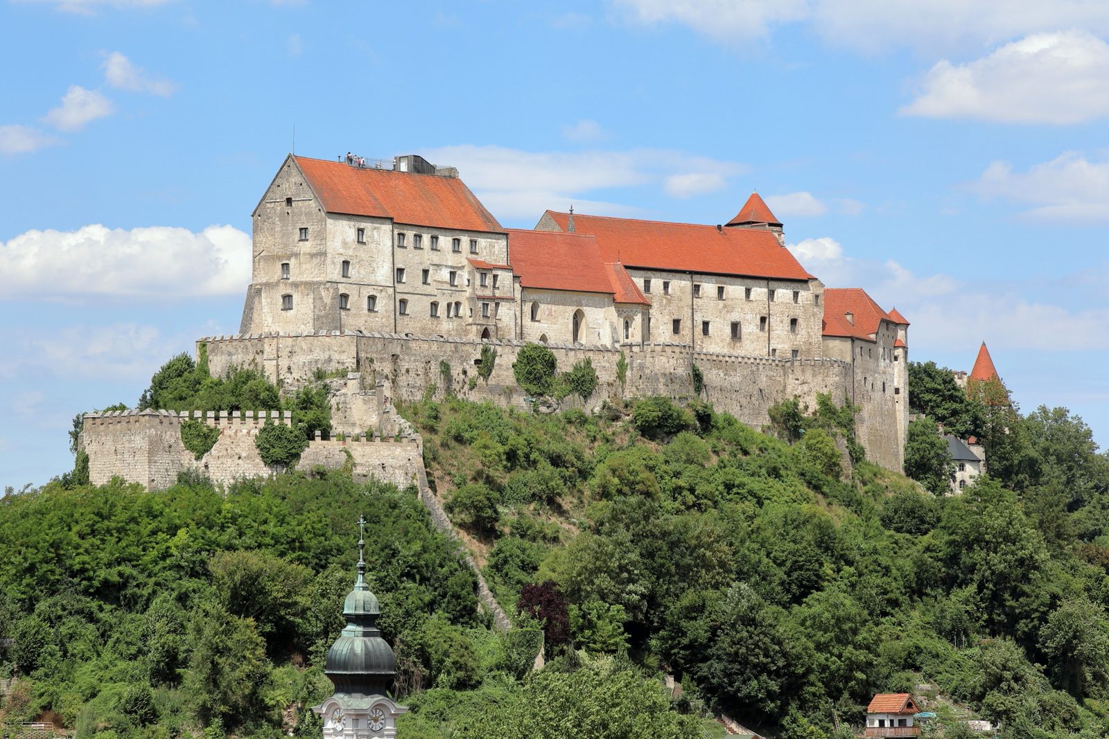
Burghausen Castle is a hilltop castle above the old town of Burghausen in Bavaria. At 1051 meters, it is the longest castle complex in Europe and has been listed in the Guinness Book of Records as the "longest castle in the world". It consists of six castle courtyards and is built almost entirely of tuff ashlar stones (travertine), with a few exceptions. A large part of the buildings and the character of the entire complex date from the time it served as a residence and state fortress for the Lower Bavarian line of the Wittelsbach dynasty, especially from the years around 1480 to 1503. After its role as a residence ended in 1503/05, Burghausen housed the Rentamt (revenue office) until 1802, which led to further extensions and alterations of the castle. As a garrison location (1763–1891), the castle underwent significant changes once more. Large parts of the buildings were demolished, not least under French occupation around 1800. The extraordinary location of the castle hill led to settlement in the area of the present main castle as early as the Bronze and Iron Ages. Furthermore, excavations uncovered numerous traces from Celtic and Roman times. Apart from foundation remains, the oldest parts of the castle date from the High Middle Ages, and the oldest written mention still preserved dates from 1025. The complex is listed under file number D-1-71-112-52 as a protected architectural monument of Burghausen. It is also listed as an archaeological monument under file number D-1-7842-0074 in the Bayernatlas as "underground medieval and early modern findings in the area of Burghausen Castle and its predecessors, as well as a hilltop settlement of the Bronze Age, Urnfield Culture, Hallstatt Period and early La Tène Period, and inhumation graves of the High Middle Ages".
Geographical Location+
The location of the hilltop castle (ridge castle) (420 m above sea level) is the northeastern Upper Bavarian Alpine foothills, in the area of the former Inn-Salzach glacier and now near the border to the Austrian district of Braunau. The surrounding landscape is hilly, relatively heavily forested, and traversed by a number of cold rivers from the nearby Alps towards the Danube. One of them is the Salzach, on whose banks the old town of Burghausen (360 m above sea level) is located.
The castle buildings stretch along a narrow and elongated ridge that separates the river and the old town from the opposite Wöhrsee, an oxbow lake of the Salzach. The main castle is at the southern end, one kilometer further north is the only ground-level entrance to the castle. The slopes to the west, east, and south drop steeply and are covered with grass and individual trees. The location on this elongated ridge was extremely favorable for defense. It is certainly also a reason why the castle was never conquered by storm. The immediate proximity to the German-Austrian state border is a result of modern developments; during the heyday of the town and castle in the late Middle Ages, the Innviertel, located on the other side of the river, was part of the Wittelsbach dominion, and the castle was thus not an immediate border fortress.
History+
Up to the Early Middle Ages+
During extensive excavations under the Dürnitz from 2002 to 2004, a number of pottery shards were found, among other things, which are dated to the 16th century BC. This confirmed a long-held suspicion that the castle hill in Burghausen had been settled since the Bronze Age, which is also attested by arrowheads, knife/sickle fragments, casting cakes, garment pins, ceramics, and a dagger. The discovery of remains of a dry stone wall from the same epoch, also under the Dürnitz, is considered a "small sensation". Numerous relics from the Iron Age also came to light during these excavations. In the 2nd and 1st centuries BC, a Celtic section fortification probably existed on the area of the present main castle; numerous finds of Celtic fibula parts and coins are strong evidence for this assumption. The same applies to the epoch in which present-day Burghausen was part of the Roman province of Noricum; coins from Emperor Marcus Aurelius to Emperor Constantine and Roman fibulae were discovered during excavations from this period. Since then at the latest, the fate of the settlements was inextricably linked with the salt trade via the Salzach. Today, a more or less continuous use and settlement of the area since the Bronze Age is assumed. From the early Middle Ages, there are only sparse indications of buildings on the castle hill. From the 8th to the 10th century, a fortified official's court of the Agilolfingian dukes probably stood on the site to monitor salt shipping – foundation remains suggest this. Numerous settlements from this period can also be found in the nearby surroundings, and the Inn-Salzach estuary area was the geographical center of the Agilolfingian sphere of influence, which in the 10th century stretched from the Lech to the Vienna Woods and from the Fichtelgebirge to the Adriatic. The disintegration of the Agilolfingian stem duchy resulted in the area around Burghausen Castle being located between the Prince-Bishopric of Passau, the Prince-Archbishopric of Salzburg, the Duchy of Austria, and the Provostry of Berchtesgaden.
High Middle Ages+
In 1025, during the reign of the last Luxembourger Duke Henry V of Bavaria, Burghausen was documented as an imperial estate – its oldest mention. At this time, as throughout the 11th century, the seat of the Counts of Burghausen, a collateral line of the Sieghardinger, can be traced on the castle hill. A first major expansion took place around 1090, and fragments of the palas from this period are still preserved. In 1130, the settlement below the castle was granted market rights, and Burghausen was already referred to as 'urbs' in sources. In 1140, the predecessor of the present Jakobskirche was consecrated in the valley settlement. After the death of the last Count of Burghausen, Gebhard II, the castle finally passed into the possession and sphere of influence of the Wittelsbachs in 1168; parts of the associated lands went to the Babenbergs. From 1180, under the rule of the Wittelsbach Otto I, the first Duke of Bavaria, the castle was massively expanded. Finally, in 1235, the year of Henry XIII's birth, Burghausen received city rights; by then, a considerable settlement for medieval standards had developed between the castle and the Salzach. After the first division of Bavaria, a completely new complex was built from 1255 under the approximately 20-year-old Duke Henry XIII, parts of which are still preserved within the main castle today. The inner castle chapel from this year is considered the oldest early Gothic church in southern Bavaria. The Dürnitz and Kemenate also date from the mid-13th century. From this point on, Burghausen Castle served as the second residence of the Dukes of Lower Bavaria alongside Trausnitz Castle in Landshut.
Late Middle Ages and Beginning of the Renaissance+
The two subsequent centuries saw the most important and intensive construction periods. After another division of Bavaria among the sons of Stephen II in 1392, Burghausen Castle remained the second residence of the newly created Bavaria-Landshut line. The first regent was Duke Frederick the Wise († 1393). Under the three "rich" Wittelsbach dukes of this line (Henry 1393–1450, Louis 1450–1479, and especially George 1479–1503), the castle complex was massively expanded and acquired its present character. Especially the fear of the approaching Turks led to a strong fortification expansion from about 1490, for which the ducal armorer and court architect Ulrich Pesnitzer was responsible. The main burden of the construction measures had to be borne by the surrounding farmers. As a residence, the castle had to offer space for a functioning community in addition to its function as a fortress. The complex took on the form of a self-contained, spacious defensive and residential castle. The enormous dimensions – during this time the castle reached its present length of over one kilometer – even allowed for the creation of larger gardens. The stables housed several hundred horses. Workshops, residential and administrative rooms, and several churches were distributed among the various castle courtyards. The inhabitants were distributed according to their status from "top" (main castle) to "bottom" (sixth castle courtyard). With the War of the Landshut Succession (1504/05) and the associated "reunification" of the Bavarian duchies under Albert IV, Burghausen lost its status as a residence. Instead, the castle now served the sons of Duke Albert as a so-called "prince's residence". At this time, the chronicler Johannes Thurmayr, better known as Johannes Aventinus, also lived in Burghausen for some time – though not in the castle building, as a plaque and even the name of the house ("Aventinushaus") today report.
Modern Era+
Due to its extraordinary location and its function as a main armory, the castle continued to have great military importance during the transition from the Middle Ages to the early modern period. Further alterations were made from the 16th to the 18th century under the premise of defensibility; the residential character slowly receded into the background architecturally as well. A detailed overview of Burghausen Castle a few decades after its heyday as a residence is provided by Jakob Sandtner's famous city model from 1574. In the 17th century, during the Thirty Years' War, the fortification was particularly strengthened, especially against the Swedes approaching in 1632. In this context, the Swedish Field Marshal Gustav Graf Horn was imprisoned in the dungeon of the main castle from 1634 to 1641. In the 18th century, the outer works of the castle were extended according to the system of the fortress builder Sébastien Le Prestre de Vauban. After Bavaria's involvement in the War of the Austrian Succession 1740–1748, extensive alterations followed, especially after Burghausen was appointed garrison town in 1763. As a result of the War of the Bavarian Succession 1778/1779 and the subsequent Peace of Teschen, Burghausen became a border town due to the cession of the Innviertel to the Duchy of Austria; although the border demarcation along the Salzach was briefly revised again under Napoleon I, the Innviertel finally went to the Austrian Empire after the Congress of Vienna in 1814/15. During the Napoleonic occupation, all northern outer works were demolished by French troops under Marshal Michel Ney in 1800 and 1801. This exposed the only vulnerable, ground-level access to the castle. In 1809, Napoleon I declared the fortress obsolete. In the decades thereafter, numerous alterations were made by the garrison of the Royal Bavarian Army stationed in Burghausen (1816–1849: 1st Jäger Battalion, 1849–1878: 2nd Jäger Battalion, from 1878: I. Battalion of the 16th Infantry Regiment), while parts of the castle were simultaneously sold privately. The garrison was disbanded. A planned demolition of the castle was prevented by Burghausen citizens. In 1896, a first renovation of the main castle began, which partly significantly altered the appearance of the complex. Since the 1960s until today, the entire castle complex has been continuously renovated. Recently, there have also been attempts to reverse later interventions (especially from the 19th and 20th centuries), which is not uncontroversial. Today, the castle largely belongs to the Free State of Bavaria and is under the Bavarian Administration of State Palaces, Gardens and Lakes, or Bayerische Schlösserverwaltung for short. This rents out parts of the castle as apartments, others as event venues. In the main castle as well as in other parts of the castle, there are several museums, namely the State Castle Museum with the ducal living quarters and a branch gallery of the Bavarian State Painting Collections, the Burghausen City Museum, a Torture Museum, and a Photography Museum.
In 2004, the castle was one of the two main exhibition areas of the Bavarian State Garden Show. For this purpose, extensive renovation measures were again carried out between 2002 and 2004. Since then, it has been possible to access the entire upper outer bailey of the main castle. In addition, archaeological excavations in the area of the main castle (Dürnitz) brought to light remarkable finds, which can now be viewed in the visitor center of the main castle. From April 27 to November 4, 2012, the Haus der Bayerischen Geschichte and the City of Burghausen, in cooperation with the Bavarian Palace Administration and the Office of the Upper Austrian State Government, organized the Bavarian State Exhibition in the castle complex with the title: Bavaria and Austria in the Middle Ages: Allied – Antagonistic – Related. In this context, the Burghausen City Museum was rebuilt and completely redesigned. Further exhibition venues on the Austrian side were Mattighofen Castle, which was acquired and renovated by the municipality for this exhibition in 2007, and the former Augustinian monastery Ranshofen in Braunau am Inn.
Architectural Description+
Main Castle (First Courtyard, Inner Castle Courtyard)+
The main castle in the south, also called the inner castle or inner courtyard, represents the oldest part of the castle and contains the central medieval elements: palas, Dürnitz, Kemenate, castle chapel, as well as the so-called treasury and the dungeon. The last major expansion took place at the end of the 15th century and the beginning of the 16th century. In the entrance gate of the main castle, on the east side, the so-called gatekeeper's room is embedded. Both were built in this form around 1480. Between the entrance gate and the inner castle gate (Elsbethen Gate) lies the gatehouse of the main castle. The Elsbethen Gate is connected to the mighty, seven-story keep and the shield wall and could be quickly closed with a portcullis in emergencies. The inner castle courtyard is closed off at the south end by the palas, in the west by the Kemenate, and in the east by the Dürnitz and the inner castle chapel. Diagonally above the Elsbethen Gate, on the inside, a 16th-century painting depicting a scene with the Three Wise Men is visible.
The three-story, in the middle part four-story Kemenate on the right side to the west was probably the residence of the Duchess's court. The outer walls and oldest parts of the interior date from the 13th century. The late Gothic groin and net vaults on the ground and first floors are impressive. The upper floors were last altered in the 16th century and feature wooden ceilings with heavy beams. Today, the rooms of the city museum are located here. The Kemenate is connected to the Dürnitz by a flying arch. The arch is painted with the Bavarian and Baden coats of arms and the year 1523, which is intended to commemorate the marriage of Duke Wilhelm IV of Bavaria to Jakobäa of Baden. However, the arch was built decades earlier.
Opposite the Kemenate, on the left side to the east, is the Dürnitz building. On the ground floor, the Zehrgarden, a storage room of the ducal court, is accessible from the main castle courtyard via a few steps. It was converted into a visitor center in 2004, during which the columns, among other things, were freed from later constructions and restored to their original octagonal state. The columns, like the cross-ribbed vault, date from the 15th century, the meter-thick outer walls from the 13th century. During excavations from 2002 to 2004, wall remains and graves from the early Middle Ages were found, which are exposed and can be visited. On the first floor, also under cross-ribbed vaults, are the dining hall (Dürnitz) of the entire ducal court and the kitchen. The Dürnitz was one of the few rooms that could be heated smoke-free by a rear-loading stove even in the Middle Ages. A source from 1509 speaks of 38 tables that found space between the columns. The room is elongated with two naves of five bays each. It was probably also used as a negotiation and common room. The second floor was occupied in the 15th century by the ballroom, the representative large hall for especially summer court festivities. It was later, especially during the garrison period, heavily altered and divided and is now without special structural significance. The same applies to the attic; it was only added in the early 18th century in the form of a gable roof to the originally crenellated flat roof.
Between the Dürnitz and the Palas is the Elisabeth Chapel, built in 1255. Its late Romanesque core was altered in the late 15th and early 16th centuries and today houses a choir altar with a shrine from 1524. Frescoes dating back to the 14th century can be seen on the ceilings of the single-nave building. The bell in the tower dates from 1474. From the chapel, one can directly access the ground floor of the Palas opposite the courtyard gate, which, like the Zehrgarden, is a few steps below the level of the castle courtyard and is irregularly arranged due to the terrain and frequent alterations. The ground floor probably also dates from the late Romanesque construction phase under Duke Henry XIII, the outer walls perhaps even from the 12th century. At the southern tip is a trapezoidal room with a mighty central support; to the north, a three-part room with three bays each adjoins it. The ceiling again consists of heavy cross-ribbed vaults. On the first floor of the Palas is the former three-part suite (apartment) of the Duke. It consisted of two stove-heated rooms and a sleeping chamber in between; the small room with the bay window probably served as a writing room or as a studiolo according to French and Italian models. On the anteroom (Fletz), the year 1484 can be seen above a door leading to the ducal apartment. The rooms are mostly preserved in the condition from these years of Duke George the Rich's reign, with heavy oak supports, ceiling timbers, and a bay window. On the second floor are the similarly arranged former chambers of Duchess Hedwig of Poland, which are also largely preserved in their original state. She stayed here for extended periods, while her husband resided mainly in Landshut at Trausnitz Castle. Today, in the first castle courtyard, in addition to a small private residential part and the Dürnitz visitor center, are the Castle and City Museum and the Bavarian Painting Gallery, where, among other things, the ducal living quarters and the Kemenate can be visited. The connection across the deep moat to the adjacent second castle courtyard is a relatively new wooden bridge. Downhill, on the remaining three sides of the main castle, are the upper and lower outer baileys, i.e., high walls located in front of the castle. A several hundred-meter-long battlement connects the main castle with the artillery and battery tower, the so-called Pulverturm (Powder Tower), located on the other side of the Wöhrsee, which was built around 1500 by Ulrich Pesnitzer. It has walls up to five meters (!) thick, four stories, and a deep well on the ground floor, from which the tower crew could supply themselves with water in case of a siege.
First Outer Bailey (Second Castle Courtyard)+
The second castle courtyard, also called the First Outer Bailey, which was built in its present form in the late Middle Ages as the first extension to the main castle, contains few of the original buildings and defensive walls. The stables, which housed over 100 horses in the 15th century, and the court bakery (both from 1478), which stood on the west side of the courtyard, have disappeared. They were demolished during the garrison period to create space for exercises. The same applies to the ducal horse baths, whose remains were archaeologically investigated between 2002 and 2004. Only the dwellings of the stable masters and carters have been preserved; however, these have been repurposed and structurally adapted several times. During the time of the Burghausen garrison, the buildings served as a canteen; today, they house a kiosk and public toilets. The defensive walls of the second castle courtyard have been removed to about chest height and now offer magnificent views of the old town (to the east) and the Wöhrsee (to the west). Of the former brewery near the Röhrenbrunnen (pipe well), only a construction shed remains, which is now the castle café.
Near the moat to the first courtyard stands the so-called Kammerer Tower ("Rundel"). From it, an underground passage is said to have led into the city, even under the Salzach into what is now Austria. The well-known folk music researcher and museum director Hans Kammerer lived here. Right next to it in the moat – which is 8 m deep and 27 m wide – is a covered well over 50 m deep. Three small gates lead from the moat: to the "Rundel", south into the lower vault of the outer gatehouse of the first courtyard, and north to the first outer bailey. At the southwest corner of the second courtyard, a few meters west of the moat, stands an observation tower, which was formerly a tower at the entrance to the lower outer bailey. On the east side there is a descent to the old town, probably the oldest connection between settlement and castle. It leads via the Burgsteig and the Geistwirtgassl to the town square. Slightly in front of the defensive walls is the Stephansturm with a gate, whose core dates from the 13th century. In the 19th century it was called Kasernberg. With it, access from the old town could be closed. Between the Stephansturm and the old defensive wall is a stepped embrasure, stepped like modern embrasures e.g. of the Atlantic Wall; the stepping prevents projectiles from the direction of the Stephanstor from being directed into the embrasure. Since the view from the embrasure to the Stefanstor was blocked by a tower, a viewing embrasure was worked into this tower. Above the path to the old town are the former dwellings of the stable masters and carters and the so-called tower of the "uppermost squire" (always ready alarm guard) with a crenellated crown. To the north, the second castle courtyard is closed off by the Georgstor. Formerly it also bore the names St.-Elsbethen-Tor, Hochtor and Prinzentor. It got this name from the tower master Jacob Primbs, who had to move his apartment as tower master from the keep of the main castle here around 1600. The gatehouse was built in 1494 and has been preserved almost unchanged. It consists of two towers and a mighty transverse bar between them. It delimits the courtyard to the north towards the third castle courtyard and was built to protect the main castle. On the southwestern part of the gate, a piece of the defensive wall is still preserved at its original height. In front of the Georgstor is a deep defensive moat, spanned by a wooden bridge. On the Georgstor, above the entrance, there is a late Gothic Bavarian-Polish alliance coat of arms, which commemorates the marriage of Princess Hedwig of Poland to Duke George of Wittelsbach (Landshut Wedding, 1475), the namesake of the gate. On the Polish coat of arms, the white eagle of the Piasts and the Lithuanian knight can be seen. The second courtyard, with the main castle, belonged to the inner castle area. Anyone found there without permission risked being punished by having their ears cut off.
Second Outer Bailey (Third Castle Courtyard)+
The third castle courtyard, also called the Second Outer Bailey, is dominated by a three-story old tuff ashlar building, the armory from no later than 1427. It already stood before the enclosure and design of the area as a castle courtyard in its present form. The intermediate ceilings are designed as heavy wooden constructions, supported in the middle by seven brick pillars each. A munitions inventory from 1533 reports that 185 cannons, including a heavy stone cannon ("Esl"), as well as culverins, arquebuses, and ammunition, were stored on the two lower floors. The stone balls that today adorn the edges of the paths in the castle complex were also intended as ammunition for cannons. The armory was renovated in 1692 and significantly altered structurally in the 19th century (the roof truss was flattened). Its original function was that of a storage place for grain on the upper floors and weapons and cannons on the ground floor. The forge, formerly directly adjacent to the north, no longer stands; only the roof attachments on the north side of the armory can still be seen.
The eastern side of the courtyard is bordered by the so-called "Pfefferbüchsen" (pepper boxes), three small artillery and defensive turrets. From the third castle courtyard, steep paths lead through breaches in the defensive wall made in modern times, to the east into the old town (Stethaimer Weg) and to the west through the breach "Zur Schönen Aussicht" (To the Beautiful View), once a place of execution. Another preserved building in the third castle courtyard is the former dwelling of the armorer: the Hofkastengegenschreiber Tower, also called the Büchsenmeister or Zeugwärtl Tower, which later also served as the major's residence for the garrison commander, transitions into the actual defensive wall via the so-called "Schwurfinger" (oath fingers) – a masonry decoration in the form of swallowtail battlements. For a long time, there were wild speculations regarding the function of these oath fingers, until they were finally identified as unambiguously and prosaically as pure wall decoration. The ridge is particularly narrow at the height of the third castle courtyard, so the development here was probably never as extensive as in the other courtyards. The former composition of artillery turrets, artillery and ammunition storage, and a forge is striking. Moreover, the change in the overall character due to the removal of the defensive wall to chest height is also very clearly noticeable in the third courtyard.
Third Outer Bailey (Fourth Castle Courtyard)+
The fourth castle courtyard, also called the Third Outer Bailey, is bordered on the east by the Haberkasten or Langer Kasten. Originally built between 1387 and 1427 as a 120 m long large stable (stables for about 100 horses) and warehouse for fodder supplies, it was demolished in 1878 to create a gymnasium for the garrison. In 1960/61, a new building was erected according to the original floor plan and in the original location as a youth hostel. After the youth hostel moved to the old town, it housed the Athanor Academy for Performing Arts from 1995 to 2014, which subsequently moved to Passau.
The adjoining late medieval Kornmesserturm or Getreidewärtlturm to the south initially served as the dwelling of the warehouse manager, the "Kornmesser" (grain measurer), later of the sacristan of the inner castle chapel. During the garrison period, it was the sutler's shop. The chaplain of the inner castle chapel later inhabited a defensive tower opposite, extended with a late Gothic six-stepped gable, the Aventinushaus. Only remnants of the crenellated wall that formerly surrounded it are preserved. The house in its present form has a gable roof and is three stories high. The plaque affixed in the 19th century, which identifies the house as the temporary residence of Johannes Turmair ("Aventinus"), is based on an error. The north side of the fourth castle courtyard consists of a continuous building complex, the former Fronfeste (prison), which also marks the boundary to the fifth castle courtyard. The formerly existing moat had already been filled in the 16th century. The largest of the buildings was built from 1574 to 1661 as the New Armory, later also called the Double Box Watchman's Dwelling and Hospital. In 1751/52, it was extended along the old barrier wall to the 5th courtyard with a covered passage (torture passage) to the correctional or workhouse (Fronfeste). On the eastern slope to the old town, the building is bordered by the Hexenturm (Witch Tower), a prison tower with several cells, in which in 1751 the last woman executed as a witch in Burghausen was imprisoned – although in Burghausen, incidentally, more men and children were killed as "witches" than women. On the other side of the narrow gate, through which one enters the fifth castle courtyard, stands the Torture Tower (also Schergenturm, Amtmannsturm or Eisenfronfeste) as the western end of the Fronfeste. It is now accessible as a private museum, where a number of early modern torture and murder instruments can be viewed in an authentic environment. The dungeon in the cellar, whose only light source was a barred hole in the ceiling, is preserved along with cast-iron eyelets for the chained prisoners. Directly above this hole was the torture chamber (Fragstatt); the prisoners could therefore "experience" what awaited them, primarily acoustically, beforehand. In Burghausen, especially in the early modern period, thousands of people were tortured and executed; the last execution took place as late as 1831. However, the execution site was not at the castle, but on a field a few kilometers north; often the condemned were also killed directly in their places of residence as a deterrent. Burghausen was in any case the seat of the judicial authorities, which led to the following biting saying among the population: "Between Ach and Weh, Kreuz, Kümmernis and Klausen, lies the skinning nest Burghausen." Ach, Weh, (Heilig-)Kreuz, Kümmernis and Klausen are place names from the surrounding area or present-day districts of Burghausen.
Fourth Outer Bailey (Fifth Castle Courtyard)+
In the fifth castle courtyard, also called the Fourth Outer Bailey, the Spinnhäusl, a comparatively small women's prison from the 16th century, adjoins the prison complex on the east side, although it was heavily altered during a renovation in 1968. The former gardener's tower to the north, which was converted into a viewpoint as early as 1960, was also heavily altered. The wide, green space in front of the two buildings was the garden of the Vitztum in the Burghausen Rentamt. Vicedoms have been mentioned in Burghausen since 1392 and lived in the main castle since 1514. The garden has been planted with scattered fruit trees since the 2004 State Garden Show. The defensive wall on the west side was also removed to chest height here. The outer castle chapel, often called Hedwigskapelle, stylistically attributed to master builder Wolfgang Wiser (Wiesinger), is preserved in its full splendor. It was commissioned by Duchess Hedwig and Duke George of Wittelsbach and was under construction in 1489. The church was consecrated from the beginning to the "Holy Virgin Mary". The chapel is one of the important late Gothic buildings in Bavaria. Particularly significant are the vaults with ribs over a curved ground plan, which at that time were among the stylistic innovations in vault construction. Although part of the chapel is embedded in the eastern defensive wall, it captivates with its filigree character; a small porch rests on delicate red marble columns; at the corners of the porch, sandstone figures depicting the Annunciation can be seen under canopies: on the left the angel Gabriel, on the right Mary. Remains of late Gothic frescoes can be seen on the inner walls. In addition, there are late medieval votive reliefs, and from the same period, statues under canopies that directly adjoin the surprisingly irregular cross-ribbed vault. The chapel is in excellent condition; only the altarpiece is no longer original, but also dates from the late 15th century and has been on loan from the Bavarian National Museum in Munich since 1959. The northern boundary of the fifth castle courtyard is formed by the former Kastenamt (revenue office) with the later erected residential buildings from the 17th and 18th centuries and the opposite Kastengegenschreiber Tower, which burned down in 1803 and was rebuilt with alterations. Until then, the two buildings were connected by an archway and separated from the sixth castle courtyard by a deep moat. The gate was demolished and the moat filled in.
Fifth Outer Bailey (Sixth Castle Courtyard)+
While large parts of castle courtyards two to five are surrounded by defensive walls, the sixth and northernmost castle courtyard, also called the Fifth Outer Bailey, is more extensively built up with buildings again. The ridge is much wider here and gives the courtyard a square-like character. On the west side are three defensive towers from the 14th century, which were converted into the Court Clerk's, Beneficiary's, and Forester's Towers during the time of the Rentamt. In between are numerous smaller craftsmen's houses. On the east side of the courtyard, next to the Chancellor's Tower, is the Christophs-Tor to the Hofberg, a path accessible by carts to the old town. The buildings surrounding the gate date in their core from the late Middle Ages, but were structurally altered from the 16th to 18th centuries and served as administrative buildings of the Rentamt (revenue master, revenue clerk, chancellor, forester, castellan, etc.) from the early modern period. One tower served as the dwelling of the executioner of Burghausen from 1779 to 1801. Before the cession of the Innviertel to the newly emerging Austrian Empire, the executioner lived in Ach on the opposite side of the Salzach. Approximately in the middle of the sixth castle courtyard stands the picturesque clock tower with striking and sundial from the 16th century, directly attached to it a now covered well. Contrary to the usual time display, the tower clock indicates the minutes with the short hand and the hour with the long hand. From the viewpoint in the western castle wall, one has a beautiful view of the Wöhrsee (old riverbed or oxbow lake of the Salzach) and the Pulverturm, which is connected to the castle bailey by a battlement. In the background, the Leprosenkirche Heilig Kreuz (from 1477) in the district of the same name and the pilgrimage church in the Marienberg district, a Rococo building erected from 1760 to 1764, can be seen. The deep castle moat with the mighty defensive complex behind it, which closed off the castle and the entire old town to the north, is no longer preserved. All buildings were demolished at the beginning of the 19th century. Behind a deep moat, the "Halsgraben" (neck moat), there was a mighty wall with three defensive towers; behind it, as a transverse bar, the "Schütt", a multi-story granary building. Access to the castle was not straight from the north, but diagonally from the northeast via a drawbridge through the gatehouse, which could be completely closed by three gates – into the castle, to the old town, and to the north. Today, only the Christophs-Tor, the former entrance from the gatehouse to the castle, still exists. Above the former defensive moat is now the visitor parking lot, the former outer walls were partially reconstructed in 1965. One does not initially feel as if one is entering a castle – the formerly massively protected, only ground-level access from the north, which originally formed the counterpoint to the main castle in the south, appears all too open today.
Miscellaneous+
Burghausen Castle was, among other things, a filming location for the Christian Ditter film Wickie auf großer Fahrt, 1½ Ritter by and with Til Schweiger, and Hollywood filmmakers have also used the architectural authenticity of the old castle complex as a backdrop, as in the new film adaptation of The Three Musketeers.
Take Mobile History with you
You are reading this text for free. Premium adds what matters on the road: descriptions read aloud, sites found through your camera, whole regions taken offline.
- Every description, including the ~17,700 Premium sites
- Audio guide: have descriptions read to you on location
- AR finder: see sites through your camera, with distance and bearing
- Unlimited saved sites
14 days free, then from €2.99 a month. Cancel anytime.
Source: Wikipedia · Licence: CC BY-SA 4.0 · Image: C.Stadler/Bwag · Wikimedia Commons · CC BY-SA 4.0
This description is a machine translation of an excerpt from the linked Wikipedia article. The source text was written by its authors, the translation is by Mobile History; like the original it is licensed under CC BY-SA 4.0.
Location: 48.1561, 12.8290