CastleWinterscheid

Herrenstein Castle (Winterscheid)
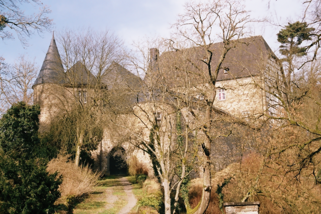
Herrenstein Castle (Winterscheid)

To be privately owned

Herrnstein Castle is a hilltop castle in the Winterscheid district of the municipality of Ruppichteroth in the Rhein-Sieg district. It is also referred to, primarily in older sources, as Herrnstein Palace.

The castle is enthroned in the Bröl valley between Bröleck and Ingersau on the southern flank of a rock cone, which still towers about 25 meters above the castle courtyard. To the west and east, the terrain slopes steeply.

Herrnstein Castle dates back to a simple fortified house built around 1300, which was owned by the Lords vam Steyne (vom Stein). The "huys zome Steyne" was first mentioned in a document in a contract dated November 15, 1370, according to which Johann von Stein received it as a fief from Count Wilhelm II of Berg. The castle then developed into a Rhenish hillside castle through multiple alterations and additions. Around 1800, significant parts of the complex were demolished and rebuilt. Further construction measures up to the 19th century gave it its present appearance.

Since 1436, the property has been owned by the noble family of Nesselrode, and even today a member of this family lives there. It is also the seat of the "Gräflich Nesselrodesche Forstverwaltung" (Count Nesselrode's Forest Administration). The exterior of the castle can be visited (usually on the first Saturday of the month from 11:00 AM). A visit to the interior of the castle is unfortunately not possible.

Complex+

Building elements from both the founding period (parts of the cellar vaults, northern shield wall) and the Baroque period (windows, roof construction, and staircase) have been preserved. Some additional buildings were rebuilt in the 20th century according to historical views (1917 east and 1953 west wing of the manor house). Characteristic of Herrnstein Castle is the execution of the upper floors of the eastern gable wall of the manor house in half-timbering. This wall is fitted over two stories between the eaves-side outer walls in such a way that the depth of the northern shield wall and the stepped construction of the southern wall on the gable side are visible.

The southern, moderately steep ascent is dominated by a gatehouse with the two original towers, which underlines the already defensive character of the complex.

The large ponds at the foot of the castle complex, a good ten meters below the castle courtyard – an oxbow lake of the Bröl – bear witness to the former complete enclosure of the castle and rock cone with moats.

Take Mobile History with you

You are reading this text for free. Premium adds what matters on the road: descriptions read aloud, sites found through your camera, whole regions taken offline.

  • Every description, including the ~17,700 Premium sites
  • Audio guide: have descriptions read to you on location
  • AR finder: see sites through your camera, with distance and bearing
  • Unlimited saved sites

14 days free, then from €2.99 a month. Cancel anytime.

Source: Wikipedia · Licence: CC BY-SA 4.0

This description draws on the facts documented in the linked Wikipedia article; Wikipedia content is licensed under CC BY-SA 4.0. Wording and editing: Mobile History.

Location: 50.8306, 7.3893