To be privately owned
Kerpen Castle

Kerpen Castle is a spur castle on a dolomite spur at 500 m above sea level in the Eifel village of Kerpen in Rhineland-Palatinate.
The exact beginnings of Kerpen Castle are shrouded in the mists of history. It is considered very likely that its builder was Sigibertus de Kerpene, first mentioned in a document in 1136, or his son Heinrich I (1142-1177). However, an exact construction date cannot yet be given.
In 1265, Theoderich II of Kerpen pledged the castle as a fief to the Archbishop of Cologne, Engelbert II of Falkenburg. The property was later divided between him and his brother Wilhelm II.
In 1299, a Theoderich III was mentioned as Lord of Kerpen. His sons later founded the three family lines Kerpen-Linster, Kerpen-Mörsdorf and Kerpen-Illingen, each of whom remained partial owners of the ancestral castle, thus making it a Ganerbenburg (jointly inherited castle).
In 1346, Konrad of Kerpen-Mörsdorf sold his share of the castle to his cousin Wilhelm II of Sombreff, who acquired another share in 1448. Together with his family inheritance, Wilhelm thus became the sole owner of the complex. After his death, a history of continuous ownership disputes over Kerpen Castle began, which would last for more than 200 years.
Wilhelm's son Friedrich died childless, so the castle fell to his sister Margarete. Through her marriage to Count Dietrich of Manderscheid-Schleiden, the castle came into the possession of the noble family of the same name.
At the beginning of the 16th century, Dietrich IV of Manderscheid-Schleiden had a castle chapel built in the Gothic style. When he died childless in 1593, his brother-in-law Philipp von der Mark seized the opportunity and had Kerpen Castle occupied by his loyal followers to assert claims to the property. The dispute between him and Philipp's widow ended in a settlement in 1611, in the course of which he bought Kerpen from the widow.
However, the ownership disputes were by no means over. In 1653, the then Count of Löwenstein-Wertheim also tried to assert his claim to ownership by occupying the castle. It was not until 1674 that the dispute between the various noble families over Kerpen was ended when the Imperial Chamber Court in Speyer awarded the lordship of Kerpen, including the castle, to the Duchess of Arenberg in a judgment. The Arenbergs remained owners until 1749, but they never realized their initial plans to convert the castle into a palace.
During the Reunion Wars, some buildings of the complex were destroyed by French troops in 1682. During the Thirty Years' War, soldiers of the French army under General Bouffleurs blew up the castle and village, leveling them to the ground.
After the capture of the Left Bank of the Rhine by French revolutionary troops (1794) and the seizure of the territory, the French administration sold the ruin for demolition to the municipality in 1803.
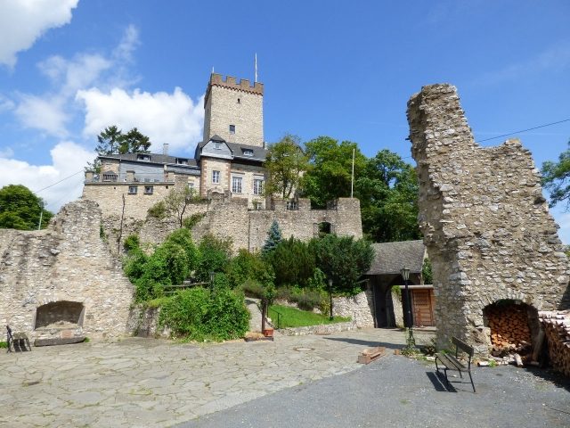
In 1893, Johann Heinrich Dün took on the dilapidated complex. He had it cleared of rubble, built the present residential house, and added a new battlement to the keep.
From 1907 to 1911, Kerpen Castle was owned by Clemens Manstein.
In 1911, the Eifel painter Fritz von Wille bought the castle from Clemens Manstein and had urgent security and repair work carried out. When the artist died in 1941, he was buried on the castle grounds.
In the same year, the company DEMAG bought the castle to use it as a training center. In the 1950s, further security, conversion, and expansion measures followed.
From 1969 to 2007, Kerpen Castle was owned by the district of Neuss, which used it as a rural school home. Then a Dutch family acquired the complex and subjected it to extensive renovation in 2010.
Description+
Kerpen Castle is a three-terraced spur complex, secured to the north by a moat about 15 meters wide towards the mountain. The battlemented, 23-meter-high keep stands on the first, highest terrace. Its uppermost floor formerly contained a dungeon.
On the middle terrace, there used to be ancillary and farm buildings, which no longer exist today. The only relic from medieval times is the 35-meter-deep well in a round building.
The lowest terrace is surrounded by a curtain wall supported by strong pillars. In the 17th century, it still housed some ancillary and burgmannen houses, before these were destroyed by French troops in 1682.
Take Mobile History with you
You are reading this text for free. Premium adds what matters on the road: descriptions read aloud, sites found through your camera, whole regions taken offline.
- Every description, including the ~17,700 Premium sites
- Audio guide: have descriptions read to you on location
- AR finder: see sites through your camera, with distance and bearing
- Unlimited saved sites
14 days free, then from €2.99 a month. Cancel anytime.
Source: Wikipedia · Licence: CC BY-SA 4.0 · Image: http://www.wehrbauten.de/thread.php?threadid=2041
This description draws on the facts documented in the linked Wikipedia article; Wikipedia content is licensed under CC BY-SA 4.0. Wording and editing: Mobile History.
Location: 50.3112, 6.7322