Cultural Events
Museum
Michelstadt Castle

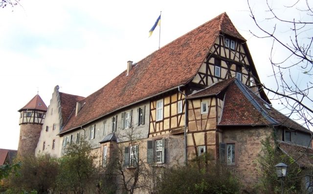
Michelstadt Castle, often and with a declining tendency also called Kellerei, is a former castle complex in Michelstadt. It emerged from a Frankish manor farm, and its predecessor building from the 10th century was destroyed in 1307. The current area was originally only the outer bailey; the former core castle is not preserved. The current complex essentially dates from the reconstruction work of the 14th century and various building measures of the 16th and 17th centuries.
The complex was purchased by the city of Michelstadt in 1970, renovated in the following years, and today houses, among other things, the Odenwald Local History and Toy Museum. The cellar of the granary occasionally serves for cultural events and various markets or as a concert hall during the "Michelstadt Music Night."
Although not confirmed by excavations or documents, it can be assumed that an Alemannic noble court originally stood on the site of the present complex. Through a donation, the Michelstadt royal estate came into the possession of Bishop Burkhart of Würzburg in 741; after his death, it returned to the crown. It likely existed as a Frankish manor farm. Einhard received the Michelstadt March for his services from Emperor Louis the Pious on January 11, 815, through a donation. Einhard himself probably had buildings and dwellings erected, so after his acquisition, the complex can be seen as a "fortified manor." He may have written parts of his main work, the Vita Karoli Magni, here. By disposition in his will, Einhard's possessions fell to Lorsch Abbey upon his death in 840. One of the abbots of this monastery, Abbot Gerbodo of Lorsch, had a stone house built there around or after 950. In the Codex Laureshamensis, the place is called castellum Michelnstat. Philipp Buxbaum found remains of a 7.40-meter-wide building in the castle courtyard during an excavation in 1938 in front of the northern, former administrative building, which was offset by about 90 degrees from it. However, he could not or would not assign the building. Another excavation in 1982 yielded no further results.
In 1307, Count Palatine Rudolf I destroyed the town and castle during the contemporary conflicts between the Electoral Palatinate and Electoral Mainz. The Electoral Palatinate regesta show that the complex had been expanded into a castle by the Michelstadt side line of the Schenken zu Erbach, which had split off in the mid-13th century. At this time, it was occupied by burgmannen. During excavations in the courtyard area of the Kellerei in 1981, a ditch was discovered, in whose backfill there was fire debris. The backfill can be chronologically reconciled with the destruction of 1307.
Although the Erbach Schenken had committed themselves in 1321 that they "should not build any castle-like structure in Michelstadt for over two years," meaning that no new complex should be built for over two years, they obviously rebuilt the castle quite quickly thereafter, as an existing castle was already reported in 1344. The builder was probably Schenk Eberhard IV. In 1388, an Irmela von Dürn, widow of a Diether Rauch, sold her property consisting of a house and courtyard in Michelstadt Castle to the Schenken of Erbach for 200 guilders. It is remarkable that although she or her husband were probably vassals of the Erbach Schenken, the property existing in the castle was an allod. This continued despite the imposed Palatine suzerainty, as in all subsequent feudal documents concerning the castle, the property sold by the widow was excluded.
From about 1390 to 1395 or about 1400, the town was surrounded by the town wall, parts of which are still preserved today, and into which the castle was incorporated to such an extent that it connected to it at two points. In 1515, Schenk Valentin moved into the castle, although he died in the same year. The complex changed noticeably with the construction of new buildings from 1517, primarily for residential and administrative purposes, probably largely under Count Georg I of Erbach. The complex was first called "Kellerei" in a document from 1532.
It is not entirely clear when the actual main castle was demolished. It is assumed that this took place around the years of the construction of the town wall, but no later than 1515. Thomas Steinmetz suspects that remains of the core castle are now located in the area of the town rampart.
Main building on the south side+
The main building, possibly the former palas of the castle in the south of the rectangular inner courtyard, bears the year 1506. It stands with its back to the town wall and originally consisted of three older parts, which were finally combined under one roof. The form of the half-timbering in the central building points to the 16th century; the side wings were added in the 17th and 18th centuries. In a long-known walled-up tower in the main building, a passage was identified in 1986. The vaulting indicates that a drawbridge was attached here from the outside. This would also suggest that a core castle in the form of a town castle was located in the still elevated rampart area outside the town wall, which has now disappeared except for suspected remains.
The building has a wall thickness of 1.60 meters in the area of the town wall, which decreases to 1.45 meters towards the east wing. The central building tract in the basement is occupied by a room measuring 5.75x5.00 meters, which is spanned by a barrel vault. The originally existing pointed arch gate was later bricked up with blind masonry and since then only offers space for a round arch door and a window.
Initially used as a residence, the main building later served as the widow's seat of Erbach countesses and finally - until its sale to the city - as a public school.
Granary, western side+
The granary in the west of the castle courtyard today houses the museum. It has a high cellar vault resting on seven mighty sandstone pillars. Its upper floors have been extensively rebuilt internally. Outside there is a double-flight open staircase, on the balustrade the alliance coat of arms of Count Georg I of Erbach and his wife Elisabeth von der Pfalz, as well as the year 1539. However, this probably only refers to the construction of the staircase itself. On the north gable, the year 1517 is found.
The building served as a tithe barn for centuries. The retaining walls towards the Diebsturm (Thieves' Tower) only date from the late Middle Ages and show great similarities to the outer wall of the core castle at Breuberg Castle.
Former Administrative Building, northern side+
This building was the actual comital "Keller," i.e., the administrative building as the seat of the comital administration, from which the entire castle received its later name. The three visible years 1501, 1549, and 1621 show that this part of the castle was rebuilt several times. A vault in the ground floor indicates that a late Gothic chapel may have been housed here. Wolfram Becher assumes, due to the currently low height of the latrine bay on the northern exterior, that a surrounding ditch originally existed here, which could have been fed by the passing Kiliansfloss stream.
Diebsturm (Thieves' Tower)+
The Diebsturm, located west of the granary, probably belonged to the old castle complex and thus dates from the 13th century. It got its name because it served as a district prison. The lower floor was completely walled up and had neither a door nor windows. Prisoners were lowered into this room from the floor above with a rope. The old cap of the tower was removed in 1798; the current one with half-timbering is modern. An ancient Roman Mercury relief was walled up at a height of about ten meters. Today, however, only a copy is there, as the original is exhibited on the first floor of the museum. Due to its disproportion and the stocky depiction, the figure suggests a "poorly trained, local" stonemason.
Take Mobile History with you
You are reading this text for free. Premium adds what matters on the road: descriptions read aloud, sites found through your camera, whole regions taken offline.
- Every description, including the ~17,700 Premium sites
- Audio guide: have descriptions read to you on location
- AR finder: see sites through your camera, with distance and bearing
- Unlimited saved sites
14 days free, then from €2.99 a month. Cancel anytime.
Source: Wikipedia · Licence: CC BY-SA 4.0
This description draws on the facts documented in the linked Wikipedia article; Wikipedia content is licensed under CC BY-SA 4.0. Wording and editing: Mobile History.
Location: 49.6780, 9.0047