Home for handicapped people
Reichenberg Castle

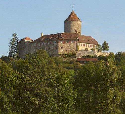
Reichenberg Castle is a Staufer-era castle complex above Oppenweiler in the Rems-Murr district in Baden-Württemberg.
The hilltop castle was built in 1230/1231 by Margrave Hermann V of Baden. It is said to have been closely related to Ebersberg Castle, built at the same time in what is now Auenwald, and the castle in Besigheim. The dimensions, facilities, and existing stonemason's marks of the three castles are consistent.
In the Middle Ages, administrative centers were usually located in castles. Reichenberg Castle was also a so-called ministerial castle. As early as 1230, the knights Wolfram and Berthold von Reichenberg are mentioned. Reichenberg was therefore an official seat and thus also the administrative center of the surrounding areas.
In the 19th century, the castle was the seat of the forestry office of the state of Württemberg; among others, Karl Schiller - a son of Friedrich Schiller - worked there as a district forester from 1822 to 1833.
In 1888, the castle was leased to the Samariterstiftung, which operated a social institution there for the care of disabled people. In 1929, the Samariterstiftung acquired Grafeneck Castle near Gomadingen and relocated the home there. Ten years later, from 1940, Grafeneck Castle became the central killing facility for Württemberg, Bavaria, and Baden as part of the Nazi euthanasia murders.
In 1930, the castle was leased to the Evangelische Gesellschaft Stuttgart, which operated a reception center for Stuttgart prostitutes there until the 1950s (prostitution had risen sharply in Stuttgart due to the general hardship after World War I). Subsequently, the home, under the direction of the Evangelische Gesellschaft Stuttgart, became a home for disabled people again.
Since 2007, the home has been operated by Paulinenpflege Winnenden e.V. The current owner of the castle is the state of Baden-Württemberg. Castle tours are possible for groups by prior arrangement. Reichenberg Castle represents the best-preserved Romanesque castle in the Rems-Murr district.
Complex+
The construction of the castle was a matter of representation and prestige. Nevertheless, the castle today gives the impression of a defensive structure with the keep having four-meter-thick walls and the mighty shield wall with a half-timbered battlement.
The Second Tower
Older sources indicate that there was apparently a second tower. It must have existed from the time the castle was built. When it was demolished is not known, but it is said to have stood in the second half of the 18th century. It can still be seen in numerous old pictures (e.g., in Kieser Forstlagerbuch 1685 HStAS H 107/14, No. 6).
The Palace
Between 1556 and 1562, the castle complex was extended by the south-west wing. It is referred to as the palace. This extension is partly cellared and was carved out of the natural rock in some places. It is said to have served to provide the forester with a permanent residence and administrative seat.
Defense Systems
The moat, which was originally supposed to have encircled the entire castle, is now only vaguely recognizable. It is assumed that the building material for the castle was obtained from the excavation of the moat. Previously, the moat was crossed via a drawbridge in a small tower located in front of the castle. In place of this small tower, there is now only a simple bridge that allows access to the castle.
The northeastern and northwestern curtain wall, also called the shield wall, which carries a half-timbered walkway covered with a gabled roof, has not existed in this form since the construction of the castle. Previously, there was a normal battlement in its place, of which a small section is still preserved on the southwest side.
Take Mobile History with you
You are reading this text for free. Premium adds what matters on the road: descriptions read aloud, sites found through your camera, whole regions taken offline.
- Every description, including the ~17,700 Premium sites
- Audio guide: have descriptions read to you on location
- AR finder: see sites through your camera, with distance and bearing
- Unlimited saved sites
14 days free, then from €2.99 a month. Cancel anytime.
Source: Wikipedia · Licence: CC BY-SA 4.0
This description draws on the facts documented in the linked Wikipedia article; Wikipedia content is licensed under CC BY-SA 4.0. Wording and editing: Mobile History.
Location: 48.9915, 9.4603