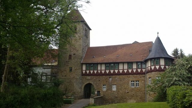
Priest's office
Wohldenberg Castle
Wohldenberg Castle is a castle ruin, located about one kilometer southwest of the village of Sillium. Sillium is a district of the municipality of Holle in the Hildesheim district (eastern Lower Saxony, Germany), whose local coat of arms is adorned by the castle complex.
Wohldenberg Castle is a hilltop castle in the northwestern foothills of the Hainberg and stands on the 218 m above sea level high Wohldenberg, which represents an elongated ridge east and above the Nette valley.
The construction of the castle on a ridge was based on strategic reasons. Due to the steep slopes surrounding it, it was difficult to capture. Here lay the northern entrance to the Ambergau and below the castle, the trade route "Frankfurter Straße" crossed with the Hildesheim-Goslar route.
Architectural Description+
The castle area was divided into the outer and main bailey, each with an inner courtyard; once there were even three inner courtyards. Access to the outer bailey is still via a gatehouse with a gate and corner tower. A bridge-like driveway spans the former moat. In the upper area of the former main bailey, which is no longer recognizable as such today, is the 32 m high keep. Other existing buildings and structural remains include parts of the up to 2 m thick surrounding wall and the Baroque-style Catholic Church of St. Hubertus from 1731, which emerged from the former castle chapel.
Middle Ages
Most likely between 1153 and 1160, Wohldenberg Castle was built by the Counts of Wöltingerode. This process was apparently related to the territorial advance of the family into the Ambergau. Count Ludolf I made Wohldenberg Castle his residence after 1174, after he had transformed his ancestral seat in Wöltingerode into a Cistercian monastery, Wöltingerode Monastery. As early as 1172, Ludolf II called himself Count of Waldeberch, and subsequent Counts of Wöltingerode increasingly adopted the name Wohldenberg.
In the dispute between Emperor Frederick I, known as Barbarossa, and Henry the Lion, the Wohldenberg counts sided with the emperor. For this reason, Wohldenberg Castle was destroyed by Henry the Lion in 1180. The castle was then rebuilt, and subsequently, the influence of the Wohldenberg counts grew. Hermann von Wohldenberg thus received Poppenburg as a fief, after Konrad II von Riesenberg, Bishop of Hildesheim from 1221 - 1246, had previously expanded it as a fortification.
In 1275, the Counts of Wohldenberg sold their county with the castle to Bishop Otto I of Hildesheim. The County of Holle henceforth formed the Amt Wohldenberg within the Prince-Bishopric of Hildesheim, as the Lower Go, along with other Ambergau villages.
In the following years, the Wohldenberg was repeatedly pledged and enfeoffed for short periods. Most of the time, however, it was in the possession of the Diocese of Hildesheim, as it is again today. Among other things, in 1174 it was in the possession of the Counts of Wöltingerode, who moved their residence here. Their former residence, Wöltingerode Castle near Goslar, was used at that time as a Cistercian nunnery, which, piquantly, set up a schnapps distillery there. Robber knights also resided at Wohldenberg at times. At the beginning of the 14th century, the castle finally remained in the possession of the von Bortfeld family for a long time. Other castle owners of this period were:
- Aschwin von Saldern,
- Knights of Wallmoden (1412)
- the Lords of Bortfeld.
Modern Era
After the Hildesheim Diocesan Feud (1519 to 1523), Wohldenberg Castle, as well as the Amt Wohldenberg, fell to the Principality of Brunswick-Wolfenbüttel. The castle owner Aschwin von Bortfeld was expelled from the castle by the new rulers without compensation. In 1518, he founded the plague column, also known as the "stone Jacob" wayside shrine, at the foot of the mountain, which still exists today. In 1704, Drost Bocholtz had it renovated.
During the Thirty Years' War, Wohldenberg Castle was finally destroyed by the Imperial forces near Bockenem in 1641. After that, the castle continued to decay and by 1800, except for minor wall remains, it was completely demolished. Previously, the inhabitants of Sillium had removed bricks for the construction of the large sheepfold in the village, and a villager from Astenbeck had bought the castle masonry for demolition. From 1858, the government in Hanover initiated restoration measures. During this process, the keep was provided with a viewing platform with a battlement. Since then, the castle ruin has been a popular excursion destination.
The new administrative building, about 200 m below the castle, was built in 1852, when the Amt Wohldenberg still had three large bailiwicks. After the dissolution of the Amt, the writer Oskar Meding lived there until 1896 and wrote his numerous historical novels in the historically rich surroundings. After his death, the house briefly served as a hotel.
20th Century
During the Second World War, the keep served as an anti-aircraft tower. Today, from the tower, one can enjoy a charming view over the municipality of Holle all the way to the Harz mountains. The gatehouse of the castle now houses the rectory of the Catholic parish of St. Hubertus. Below the castle is a residential house, which was formerly an inn from 1561, where there was a lively hustle and bustle in the period before the Second World War.
The Caritas Association of the Diocese of Hildesheim acquired the new administrative building below the castle in 1920. Since 1946, "Haus Wohldenberg" has served as a youth education center for the Catholic Church.
Take Mobile History with you
You are reading this text for free. Premium adds what matters on the road: descriptions read aloud, sites found through your camera, whole regions taken offline.
- Every description, including the ~17,700 Premium sites
- Audio guide: have descriptions read to you on location
- AR finder: see sites through your camera, with distance and bearing
- Unlimited saved sites
14 days free, then from €2.99 a month. Cancel anytime.
Source: Wikipedia · Licence: CC BY-SA 4.0 · Image: Jörg Heldt
This description draws on the facts documented in the linked Wikipedia article; Wikipedia content is licensed under CC BY-SA 4.0. Wording and editing: Mobile History.
Location: 52.0589, 10.1532