Golf Club
Zievel Castle

Zievel Castle is a medieval castle near the Mechernich district of Lessenich. It is located on the southern edge of the forest area on the Billiger Berg, near the Bundesautobahn 1, close to the Veybach valley. It can be reached via the Wißkirchen exit, Bundesstraße 266 and L 11.
Over the almost 1000-year history of the castle, the complex has had many different owners and proprietors.
In 1107, the castle was first mentioned in a document. In that year, it was in the possession of the Counts of Limburg. In the same century, a Gerhardus de Zivele is mentioned in a document in 1169.
In the 13th century, the castle was owned by the Lords of Zievel, who descended from the noble family of Daun, but in the 14th century, it passed to the Schmeich von Lissingen family, as from 1337 it was in the possession of the knight Johann Schmeich von Lissingen.
Karl von Metternich acquired the castle in the 15th century, so that in the 17th century it belonged to the von Metternich-Müllenark family by inheritance. At the end of the 18th century, however, it was already owned by the "von Roth". Since 1822, the castle, together with its associated lands, has been the property of the Krewel family, who had been its tenants since 1766. In 1828, they had the old manor house of the complex demolished.
Description+
Zievel Castle is privately owned and used as a residential and business premises. The outdoor facilities are only partially freely accessible; an 18-hole golf course was laid out in the park landscape around the manor house, keep, and outbuildings by the club founded in 1994/95. Old trees and reed-fringed ponds, which once characterized the English landscape garden, surround the partly hilly fairways.
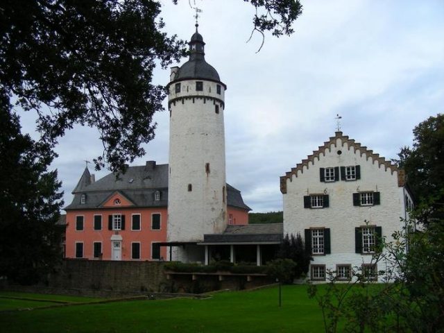
The rectangular complex was originally a moated castle, but its moats are not preserved. The round keep on the west side, heavily altered by a baroque dome and white paint, dates in its core from an older predecessor. A gate tower is located at the southwest and northwest corners. A two-story building with a stepped gable next to the keep is dated 1661, thus originating from the Metternich expansion phase. The new manor house with pink paint, which replaces the building demolished in 1828, dates from 1825 to 1828.
Take Mobile History with you
You are reading this text for free. Premium adds what matters on the road: descriptions read aloud, sites found through your camera, whole regions taken offline.
- Every description, including the ~17,700 Premium sites
- Audio guide: have descriptions read to you on location
- AR finder: see sites through your camera, with distance and bearing
- Unlimited saved sites
14 days free, then from €2.99 a month. Cancel anytime.
Source: Wikipedia · Licence: CC BY-SA 4.0 · Image: http://www.wehrbauten.de/thread.php?threadid=568
This description draws on the facts documented in the linked Wikipedia article; Wikipedia content is licensed under CC BY-SA 4.0. Wording and editing: Mobile History.
Location: 50.6180, 6.7239