CastleZülpich

Zülpich Castle

Zülpich Castle

To be privately owned

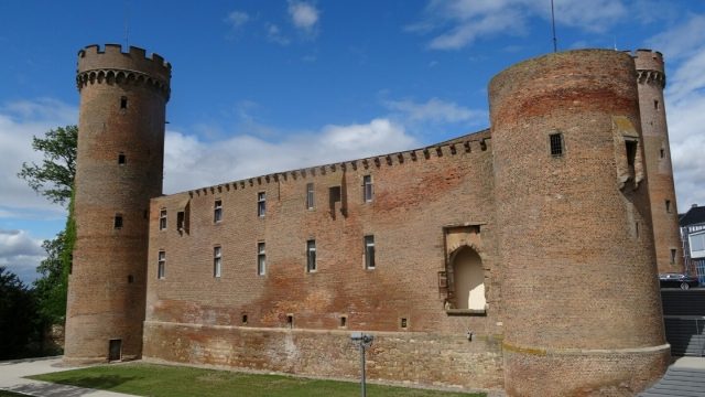
The Electoral Cologne State Castle of Zülpich is the landmark of the North Rhine-Westphalian city of Zülpich, whose origins can be traced back to a Roman "castrum". The current complex was built at the end of the 14th century as a symbol of sovereignty and an outpost of the Archbishops of Cologne against the then County of Jülich.

Burned down by French troops at the end of the 17th century, the ruins of the lowland castle came into private ownership in 1741. The Zülpich manufacturing family Sieger operated a schnapps distillery in the castle from 1870, which produced until the 1980s. Heavily damaged in World War II, it was partially rebuilt in the 1950s and today serves, among other things, as a tourist information center and club house for the Zülpich Historical Society.

Beginnings

At the site of the present castle complex, a "castrum" already existed in Roman times, which served the Merovingians as a royal palace. The Carolingians also continued to use this fortified complex and made Zülpich, with its Frankish royal court, the main town of the Zülpichgau. During the Norman invasion in 881, the complex shared the fate of the entire settlement: it was destroyed. Subsequently, the Palatine Counts of Aachen took power in Zülpich and built a castle in the 10th century.

In the struggle between Cologne and Jülich

In 953, the later Emperor Otto the Great enfeoffed the Archbishop of Cologne, in his capacity as a Prince of the Empire, with Zülpich. Excluded from this was the so-called Palenz (also Pellenz), a Frankish manor with its own church, which is known today as the former Marienkirche. The Palatine Counts granted these Palenz estates, along with the patronage over the Marienkirche and the Vogtship with the high court, as a sub-fief to the Counts of Jülich at the end of the 12th century, who were disputing with the Archbishopric of Cologne over dominion in the Erft region. Electoral Cologne therefore had the city and its castle refortified from 1255 in the struggle for power. As early as 1254, the "fortified castle" had been mentioned as a Cologne fief in an arbitration award between Archbishop Konrad von Hochstaden and Count Wilhelm IV of Jülich. It was further mentioned in the Peace of Pingsheim from 1279, in which Electoral Cologne was expressly granted the right to expand and fortify the castle. Archbishop Siegfried von Westerburg subsequently made use of this right.

After the defeat in the Battle of Worringen in 1288, Cologne had to pledge the castle and city to the Jülich Count Gerhard V in 1299. He then had the Cologne fortifications demolished and a new one built around 1350. However, after the pledge was redeemed in 1369, Archbishop Friedrich III von Saarwerden had the "Jülich Castle" torn down again and the present complex built in its place.

Modern Era

With the end of the disputes between Jülich and Cologne, the castle – like the entire city – lost its strategic importance. After severe destruction in the Thirty Years' War, it was also set on fire in 1689 during the War of the Palatine Succession by soldiers of the French King Louis XIV. Although repairs were repeatedly carried out on the complex during the 17th and 18th centuries, for example in 1664 under Elector Maximilian Heinrich of Bavaria, it increasingly fell into disrepair.

Clemens August of Bavaria gifted the useless ruin in 1741 to his Zülpich cellarer and mayor, Joseph Eberhard Wachendorff. He converted the former palas on the northwest side and the north tower for residential purposes. This resulted in a baroque, two-story building, topped by a mansard roof, and some outbuildings.

Through the marriage of the heiress Margaretha Katharina Wachendorff to Heinrich Xaver Sieger, the complex came into her husband's possession in 1847. He had the outbuildings erected by his father-in-law demolished in 1869 and, instead, built a factory building on the northeastern exterior of the castle in 1870, as the new owner established a schnapps distillery in the complex, which operated there until the 1980s.

From the 20th Century onwards

On Christmas Eve 1944, the complex was severely damaged by Allied bomb hits. About half of the building fabric was destroyed as a result. The war damage was repaired after 1950, and the castle was rebuilt in a simplified form, partly with existing building materials. This included the restoration of the outer walls, but not of the baroque residential building. In its place, a simple factory building was erected in the inner courtyard of the complex.

The Sieger family sold the castle and distillery to Maywerke in 1979, which shut down operations after some time. For 25 years, the complex stood empty and unused, leading to renewed decay. After it was sold to private investors in June 2003, they had it restored in stages from 2007 to give the buildings a new purpose. Today, commercial and service businesses are located there. In addition, the Zülpich Historical Society, together with the city, has been operating the Zülpich History Workshop and an information point for tourists in part of the castle since 2009.

In February 2010, as part of the redesign of the moat for the State Garden Show 2014, excavations took place at the castle, during which remnants of support pillars for a bridge were discovered.

Description+

Zülpich Castle is a simple brick complex on an approximately rectangular plan with high towers at the corners. It belongs to the classic castellan castles and thus follows the late medieval ideal type. The sober-looking defensive complex almost completely dispenses with architectural embellishments, thus emphasizing its fortress character, which it acquired due to its location at the southwest corner of medieval Zülpich and its integration into the then city fortifications.

The enclosed four-wing complex was originally surrounded by a moat up to twelve meters wide. At its south, west, and east corners stand round towers, all of which were once four stories high. The southern one, however, was shortened by two stories in the 19th century due to dilapidation. In the north stands a square tower, measuring 10x10 meters, placed diagonally, with corner quoins, which is the only remnant of an older complex. Its form suggests that it probably only acquired its present appearance in the 17th century. The two round towers still at their full height are topped by corbelled, open defensive platforms with brick battlements. Trachyte was used as material for the corbels, while the pointed arch frieze above consists of tuff. All round corner towers once had habitable rooms with fireplaces and latrines. Spiral staircases are located within the up to three-meter-thick walls. The western tower, facing the city, also served as a dungeon.

The four wings formerly consisted of two-story residential buildings with high vaulted cellars. Today, only their strong outer walls remain, which also functioned as defensive walls with projecting parapet walks. The remaining building fabric of the present wings dates from a later period, as the original roofs and interior walls have not existed since the 17th century. The outer facade of the southwest wall is divided into regular axes by narrow, high, Gothic transom windows with light ashlar surrounds, interrupted only by two latrine oriels.

The best-preserved outer front is found on the southeast side with the main portal made of carefully worked sandstone ashlar, to which a drawbridge formerly led. Evidence of this includes a deep blind niche framing the pointed arch of the gate, which formerly accommodated the drawbridge, as well as the still existing roller holes for the chains. Above the portal are two diagonally placed coats of arms, whose details were presumably destroyed by French soldiers in 1794. They formerly showed the coat of arms of Friedrich von Saarwerden and probably that of the Archbishopric of Cologne.

Furthermore, there was another drawbridge on the southwest side, which allowed access to the castle without the user having to pass through the city. Building material from the "Jülich Castle" erected around 1350 at the same location was used for the support pillars of this bridge.

Take Mobile History with you

You are reading this text for free. Premium adds what matters on the road: descriptions read aloud, sites found through your camera, whole regions taken offline.

  • Every description, including the ~17,700 Premium sites
  • Audio guide: have descriptions read to you on location
  • AR finder: see sites through your camera, with distance and bearing
  • Unlimited saved sites

14 days free, then from €2.99 a month. Cancel anytime.

Source: Wikipedia · Licence: CC BY-SA 4.0 · Image: Jörg Heldt

This description draws on the facts documented in the linked Wikipedia article; Wikipedia content is licensed under CC BY-SA 4.0. Wording and editing: Mobile History.

Location: 50.6901, 6.6468