CastleGräfenberg-Haidhof

Heidenstein Castle
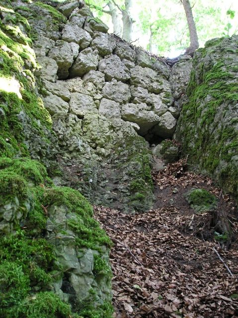
Heidenstein Castle

The remains of the castle can be visited

The Burgstall Schlossberg, also known as Burgstall auf der Flöss or Heidenstein, is a vanished, presumably High Medieval noble castle above the village of Haidhof, a district of Gräfenberg in the Upper Franconian district of Forchheim in Bavaria.

The Burgstall of the former spur castle is freely accessible at all times and serves as a viewpoint.

The Burgstall of the spur castle is located in the Franconian Switzerland-Veldenstein Forest Nature Park at 560.1 m above sea level on a rocky, southeast-facing mountain spur of the Haidhofer Schloßberg (569 m above sea level), called Flöss, which lies about three kilometers west-southwest of Egloffstein.

Nearby are also Egloffstein Castle, the castle ruin Thuisbrunn in the village of the same name, a presumed Burgstall east of Thuisbrunn, and the Burgstall Burgstein on the Burgstein of the same name near the village of Ortspitz.

There are no documentary records about the vanished castle itself, nor is its name known. The Nuremberg castle researcher Hellmut Kunstmann dates its construction to the second half of the 12th century, and it probably fell into disrepair in the early 13th century. It was located on a medieval ancient road that led from Eggolsheim via Weilersbach, Kirchehrenbach, Leutenbach, and Ortspitz past the castle, then continued to Haidhof, Thuisbrunn, and Dörnhof, and merged into the road in the Trubach valley.

An indirect mention of the castle exists in the "Gelegenhait der landschaft mitsampt den furten und helltten darinnen", a terrain reconnaissance of the Imperial City of Nuremberg before the Landshut War of Succession in 1504/05, where it states: "ein Halt", meaning a defensive position, "an der Flöß genannt".

The castle stood on the site of a prehistoric fortification, presumably a hilltop settlement of the Urnfield period, the late Hallstatt period, or the early La Tène period. A section of a rampart with an outer ditch can still be seen to the west of the vanished castle.

The archaeological monument, recorded by the Bavarian State Office for Monument Protection as a "Presumed hilltop settlement of the Urnfield period and the late Hallstatt or early La Tène period, as well as a medieval Burgstall", bears the monument number D-4-6333-0019.

Description+

The former castle stood on a rock ridge that was partly only two meters narrow but 130 meters long, first running 30 meters in a west-east direction and then turning southeast. The south side slopes steeply, while the entire north side drops about ten meters as a vertical rock face.

In front of the castle grounds, a two to three meter deep and seven meter wide pit can be seen, from which building material for the castle was probably extracted.

The slightly higher ground of the castle was separated from the mountain spur by a presumably unfinished neck ditch, into which steps lead. The ditch runs from north to south and ends after about two-thirds of the width of the mountain spur; the remaining third is probably still in its natural state. It is four meters deep and equally wide. A similar situation exists in the Ahorntal at the Burgstall on the Kandelberg near Körzendorf. There, too, the neck ditch was started, but from both sides. In the middle of the ridge, a passable remnant was left standing, probably serving for better transport of building material to the castle construction site. Between the ditch and the castle, a ledge can still be seen, which probably served as a Zwinger (outer bailey).

In the northern part of the castle's neck ditch near Haidhof, a rock tower was left standing (Image 2). This rock, sometimes referred to as a sacrificial stone, served as a bridge pier. Up to it, there was probably a solid bridge construction; after the pier, an obliquely upward leading drawbridge led to the castle entrance.

At the access to the castle, about 5.5 meters after the ditch, the outline of a square building with a side length of approximately 12 meters can be seen in the wooded area. According to Kunstmann, the wall thickness was about one meter. The southern half of the building was probably cellared, which is recognizable by the vertically worked rock. The castle path led over the bridge and then north past the presumably tower-like building into the outer bailey. The last larger preserved wall remnant is located in a rock crevice on the north side of the outer bailey (Image 1). The three-meter-high retaining wall still consists of five layers of hewn ashlar blocks, which are up to 50 centimeters wide.

On the remaining grounds of the outer bailey, apart from artificial rock workings, no further traces of buildings are visible. The outer bailey is separated from the main castle by a three to four meter deep and three meter wide second neck ditch. It is spanned by a wooden walkway, where a second former drawbridge is probably to be assumed. Immediately after the section ditch, rock workings indicate a gatehouse. A little further on, the slipped wall remains of a vanished building about five meters wide can be seen.

The last section of the castle at the tip of the mountain spur consists of a 5 by 12 meter plateau, on which no wall traces are visible anymore and which serves as a viewpoint.

Take Mobile History with you

You are reading this text for free. Premium adds what matters on the road: descriptions read aloud, sites found through your camera, whole regions taken offline.

  • Every description, including the ~17,700 Premium sites
  • Audio guide: have descriptions read to you on location
  • AR finder: see sites through your camera, with distance and bearing
  • Unlimited saved sites

14 days free, then from €2.99 a month. Cancel anytime.

Source: Wikipedia · Licence: CC BY-SA 4.0 · Image: http://de.wikipedia.org/wiki/Datei:Haidhof-Schlossberg-Mauerreste.jpeg

This description draws on the facts documented in the linked Wikipedia article; Wikipedia content is licensed under CC BY-SA 4.0. Wording and editing: Mobile History.

Location: 49.6928, 11.2191