CastleNeuwied - Altwied

Altwied Castle

Altwied Castle

The remains of the Castle can be visited

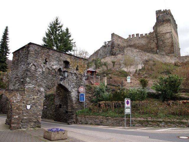
Altwied Castle is the ancestral castle of the Counts of Wied. The hilltop castle stood in what is now the Altwied district of Neuwied in the Neuwied district in northern Rhineland-Palatinate. The ruin is owned by the family of Wied and can be visited.

Altwied Castle is not to be confused with the almost identically named Electoral Cologne Castle Altenwied, which is located about 25 km further up the Wiedbach valley near Neustadt and originates from Thuringian possession. In contrast to this upper Wied Castle (Altenwied, Electoral Cologne), the lower Wied Castle (Altwied, County of Wied) was initially called "Niederwied", e.g. in 1301 "comicia de Niderwide", later occasionally "Grafenwied" and only after the founding of the city of Neuwied in 1653 "Altwied". In the 19th century and until 1930, the names "Niederaltwied" and "Oberaltwied" were used.

Location+

The ruin of the castle, which formed a defensive unit with the eponymous castle town, is located about 5 km north of the city center of Neuwied in the lower narrow valley of the Wied on a projecting rock bar, which is surrounded on three sides by the Wied, in the immediate vicinity of the Wiedtalstraße (L 255). With a height of 25 meters above the valley floor, it is overlooked by the ridges to the right and left of the Wied. The ruin itself is located at about 100 m above sea level.

The residential tower in the eastern part of the later main castle was built before 1129 by Metfried (Meffried) Count in Engersgau (so designated 1084, 1101 and 1105) as the center of his manorial lordship in the area of the lower Wied. In 1129, Metfried was first called "Meffridus de Widhe". The origin of the first Count of Wied and thus the progenitor of the Wied count's house is uncertain. The names of his relatives point to ancestors on the left bank of the Rhine in the southern Eifel. According to other sources (Gensicke), Metfried is said to be a descendant of the Count in Engersgau.

In 1179, the first construction phase was completed under Count Theoderich, a grandson of the founder. The castle chapel was first mentioned in a document in 1259; it was dedicated to St. George. In a letter of thanks to the then Countess, the castle town of Altwied was also mentioned for the first time in 1275, so it can be assumed that its construction began later. In the 13th and 14th centuries, the entire castle town was surrounded by a defensive wall with several towers. The defensive unit of the castle and the village that developed below the castle was accessible through three gates: Porz (= gate), Judentor (Jewish Gate) and Mühlentor (Mill Gate). During this time, the chapel in the village was also built, which at times also served as a burial place for the count's house.

Altwied is attested in 1404 as the seat of the "Hohen Veste uf den stoelen" (High Court on the Chairs), and the castle was also the seat of a special court for the castle peace and parish of Altwied. Since 1480, the castle has also been attested as an administrative seat. The castle town of Altwied, which was included in the castle ring with its freedom fortification, could not achieve any supra-local significance despite certain urban privileges due to its unfavorable traffic location. At the beginning of the 17th century, the castle and the defensive wall, whose oldest parts were by then around 500 years old, showed the first signs of dilapidation. In 1622, Hermann zu Wied, with money from his wife Magdalene, built a new house (the so-called "Frauenhaus" or "Women's House") on the steeply sloping north side as an extension, which probably remained habitable the longest and only fell into disrepair in 1800. This house was Magdalene's widow's residence from 1633 to 1657.

During its existence, the castle was never contested, conquered, or even destroyed.

Because the castles of Altwied and Braunsberg were remote and began to fall into disrepair, but also because these castles no longer met the requirements of the early modern era in military and economic terms, Count Friedrich felt compelled to create new residential sites directly on the Rhine. He first began in 1648 with the construction of the open castle Friedrichstein in what is now the Fahr district of Neuwied and a small fortress in Langendorf, which he called "Neuenwied". After he received the imperial privilege in 1653 to build a city settlement here, the residence was moved from Altwied to Neuwied, and administration and court to Heddesdorf (today a district of Neuwied).

The last resident from the count's house at Altwied Castle was Friedrich's eldest son, Count Georg Herman Reinhard, who lived there with his family until 1690.

The now abandoned castle was subsequently left to decay; around 1760 it is said to have served as a quarry for Monrepos Palace. It is documented that part of the stone deliveries for the reinforcement of Ehrenbreitstein Fortress in 1792 were taken from the Altenburg ruin.

The reigning Johann Friedrich Alexander Count zu Wied-Neuwied, of the hitherto comital family, was granted the hereditary title of Prince on May 29, 1784.

Around 1880, some rooms and one of the smaller towers were restored, and occasionally the princely house held festive events there with illumination of the castle ruins. The Wied princess Elisabeth, Queen of Romania, († 1916) often and gladly stayed at Altwied.

Since 1927, the then local heritage association Altwied has been working to maintain the ruin. In 1980, the Altwied local heritage association was founded, which has since been dedicated to the preservation and maintenance of the ruin.

Castle Complex+

In terms of its layout, Altwied Castle is a shield wall castle or a section castle. The castle is located on a narrow rock ridge that projects like a bar into the narrow Wied valley and is surrounded on three sides by the Wied. To the north and northeast, the castle site slopes steeply down to the Wied. In the southern lowlands, between the castle hill and the river, lies the castle town of the same name, which together form a defensive unit.

Around the main castle, built in the 12th and 13th centuries, several successively constructed rings of fortifications are stepped, apart from the steep north side, the outermost of which, probably dating from the 14th century, encloses the entire castle town, so that the castle and town formed a defensive unit. The defense could be withdrawn in stages over three intermediate positions. The broad and squat-looking keep, which has a distinctly residential tower-like character, is the oldest part of the castle. It has a square floor plan of about 16 m × 7 m, the preserved remains have a height of about 16 m. The wall thickness on the attack side is 2 m, on the castle side about 1 m. The masonry consists of greywacke and slate, with relieving arches of tuff stone. Of the four floors, the lowest has two barrel-vaulted rooms. From the keep, the castle complex extends to the west for about 200 m, of which the main castle occupies about half.

In the middle of the paved castle courtyard is the well, which has now been uncovered again. In the northwest rises the originally three-story so-called "Frauenhaus" (Women's House), built in the 13th century, which is integrated into the ring wall and was extended around the 17th century. Over a floor plan of 20 m × 13.5 m, walls and gables still rise to a height of 19 m. In the southern part there are also various building remains, including an octagonal tower with a round-arched entrance. The castle chapel was probably located near this tower.

The path through the outer bailey to the main castle leads through a total of six gates. Numerous wall, tower, and building remains are also preserved from the outer bailey.

Fortification of the Castle Town+

The northern ring wall of the outer bailey continues into the freedom fortification of the castle town. It follows the curve of the Wied and then runs towards the upper castle. With a total length of 500 m, the wall completely enclosed the valley settlement. The wall height was 4 to 5 m, in the east the wall reached 8 m and was provided with a battlement, merlons, and a blind arcade. The wall was reinforced by four square towers, three round towers, and three gate towers. It is presumed that there was a dry moat in front of the main gate.

The Mill Gate in the north has disappeared today, and remains of the Jewish Gate in the south are preserved. Significant parts of the main gate (the "Porz") in the east, which formed the access to the town and castle and was called the "Neuwieder Tor" (Neuwied Gate) since about 1700, are preserved. A part of the eastern wall with two towers is also still preserved.

Take Mobile History with you

You are reading this text for free. Premium adds what matters on the road: descriptions read aloud, sites found through your camera, whole regions taken offline.

  • Every description, including the ~17,700 Premium sites
  • Audio guide: have descriptions read to you on location
  • AR finder: see sites through your camera, with distance and bearing
  • Unlimited saved sites

14 days free, then from €2.99 a month. Cancel anytime.

Source: Wikipedia · Licence: CC BY-SA 4.0 · Image: http://www.wehrbauten.de/thread.php?threadid=990

This description draws on the facts documented in the linked Wikipedia article; Wikipedia content is licensed under CC BY-SA 4.0. Wording and editing: Mobile History.

Location: 50.4835, 7.4672