CastleDürnstein in der Steiermark

Dürnstein Castle
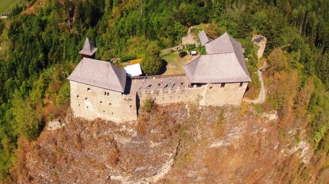
Dürnstein Castle

The remains of the Castle can be visited


Dürnstein Castle is a high medieval castle ruin near Dürnstein in Styria in the district of Murau in Styria (Austria).

Dürnstein was built on former Eppensteinian land on the constantly changing state border between Styria and Carinthia in a strategically good position. A mountain ridge extending southwest from the Alpl-Kogel narrows sharply at the border to Carinthia and drops steeply to vertically to the north, west, and south into the Olsa valley, which narrows to the north. One descends up to a hundred meters above the valley floor and reaches on a rocky spur the once important border fortress of Dürnstein, built in a perfectly protected location.

Below the ruin ran the formerly so-called "Italian main road", where the imperial and royal border toll between Styria and Carinthia was also established at this point.

In 1144, the castle was first mentioned in a document as castrum Dierenstein. It was the seat of the Dürnstein family, which died out in 1192. After the extinction of the Dürnsteiners, the castle came into the possession of the Wildoners; their branch residing in Dürnstein named themselves after the castle. Subsequently, the castle was acquired by the regional princes in 1299 and remained in their possession until 1608. Around 1500, the castle received a water pipeline. The castle fell into disrepair from the end of the 16th century and was abandoned in 1610. In 1809, Austrian troops used the ruins as cover against the advancing French.

Layout+

Coming from the north, the access to the castle is preceded by a round tower with a pointed bulge, the lower part of which consists of rubble masonry reminiscent of ashlar masonry, which probably dates from the 13th century; thus, the tower is likely one of the oldest surviving parts of the castle. The wall of the ascent path to the south forms a zwinger to the west, whose layered rubble masonry is largely attributed to the 14th century, but there are also sections of ashlar masonry or opus spicatum, which are dated to the 12th-13th century. Following the path further south, after a bend in the path to the west, one reaches a reconstructed castle gate, which borders the east wing, standing in a north-south direction, to the north. While the layered rubble masonry of the east wing refers to the construction period, the upper floor appears almost recent. Through the reconstructed castle gate, one enters a gate hall preserved in its original state with a cross-vaulted ceiling. Directly on the steep slope dropping vertically to the southwest is the west wing, which dates from the time of the tower; a series of closely spaced, 1.7 m high embrasures are located on the somewhat younger west wall. The spacious castle courtyard between the east and west wings is bordered to the north by a curtain wall with elongated embrasures, which runs along the edge of the break-off. A later added connecting wing between the east and west wings closes the castle courtyard to the south.

Take Mobile History with you

You are reading this text for free. Premium adds what matters on the road: descriptions read aloud, sites found through your camera, whole regions taken offline.

  • Every description, including the ~17,700 Premium sites
  • Audio guide: have descriptions read to you on location
  • AR finder: see sites through your camera, with distance and bearing
  • Unlimited saved sites

14 days free, then from €2.99 a month. Cancel anytime.

Source: Wikipedia · Licence: CC BY-SA 4.0 · Image: http://www.wehrbauten.at

This description draws on the facts documented in the linked Wikipedia article; Wikipedia content is licensed under CC BY-SA 4.0. Wording and editing: Mobile History.

Location: 46.9900, 14.3919