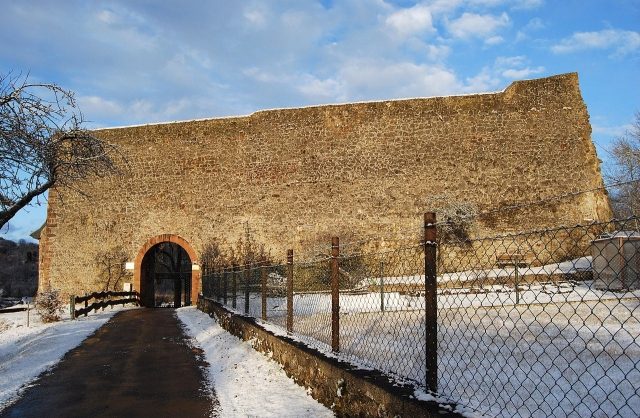
The remains of the Castle can be visited
Gerolstein Castle

Gerolstein Castle, also known as Löwenburg or Gerhardstein Castle, is the ruin of a hilltop castle near the town of Gerolstein in the Vulkaneifel district in Rhineland-Palatinate. The hill castle is located above Gerolstein in the area "An der Burg", next to Gerolstraße, east of the center. The ruin lies on a rocky hill, concealed by a protruding rock, and rises above the Kyll valley, a left tributary of the Moselle and also the longest river in the Eifel.
The Löwenburg is first mentioned in a document in 1115, when Gerhard von Blankenheim moved his seat of power to the Gerhardstein Castle built by him (from which the place name Gerolstein probably derives). In the 13th century, Gerhard IV expanded the castle into a fortified castle with an outer and inner bailey. After the extinction of the Blankenheim family, Gerhardstein Castle passed to the Loen family in 1423. In 1486, it was supplemented by two chapels. In the 16th century, the shield wall with a thickness of two meters was erected.
In 1670, the castle was severely damaged by a lightning strike in the powder tower. On July 6, 1691, it was occupied by the French, but recaptured on August 5 of the same year. Gerolstein was destroyed in the process. In 1840, the castle was also referred to as Jungkernburg. The remaining wall remnants were partially removed in the 18th century and further destroyed in World War II. Today, only a few remnants remain, but they have been restored.
Layout+
The formerly large castle complex with an outer bailey in the north and a main castle was protected by a mighty 2-meter thick shield wall, 11 meters high and 35 meters long, as well as two chapels from 1486, a castle chapel within a half-tower and a courtyard chapel below the rock.
Take Mobile History with you
You are reading this text for free. Premium adds what matters on the road: descriptions read aloud, sites found through your camera, whole regions taken offline.
- Every description, including the ~17,700 Premium sites
- Audio guide: have descriptions read to you on location
- AR finder: see sites through your camera, with distance and bearing
- Unlimited saved sites
14 days free, then from €2.99 a month. Cancel anytime.
Source: Wikipedia · Licence: CC BY-SA 4.0 · Image: http://de.wikipedia.org/wiki/Datei:L%C3%B6wenburg_Gerolstein_2012_Schildmauer.jpg
This description draws on the facts documented in the linked Wikipedia article; Wikipedia content is licensed under CC BY-SA 4.0. Wording and editing: Mobile History.
Location: 50.2213, 6.6678