CastleSteinbach-Hallenberg

Hallenburg Castle
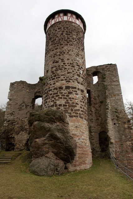
Hallenburg Castle

The remains of the Castle can be visited

The Hallenburg is the ruin of a medieval spur castle and a landmark of the town of Steinbach-Hallenberg. It is located on the southwestern slope of the Thuringian Forest in the district of Schmalkalden-Meiningen in Thuringia, Germany. The Hallenburg lies on a porphyry rock, about 80m high, steeply sloping on three sides, on the Arnsberg. In the valley in front of the present ruin lies the town of Steinbach-Hallenberg.

Construction

By whom and when the Hallenburg was built can no longer be determined with certainty today. The construction period of 909, which Johann Sebastian Güth states in his chronicle of the city of Meiningen, is disputed, as there is no evidence. However, the dynastic minor rule of the Lords of Hallenberg could go back to the beginning of the 12th century, as the border course of a Reinhardsbrunn monastery document from 1111 allows conclusions about a dominion around the Hallenburg. The Hallenburg is also said to have been among the castles destroyed by Emperor Otto IV in 1212, which suggests that the present ruin was erected on older foundations by the Lords of Hallenberg at the beginning of the 13th century.

First documentary mention

In 1228, during the disentailment of Rohr Monastery, Reginhald von Haldinberc, among others, is mentioned as a witness. With the acquisition of the Hallenberg lordship by the County of Henneberg in 1232, the dynastic minor rule ended. In 1232, Reinhard von Hallenberg is mentioned as a Henneberg vassal. From the middle of the 13th century, the Hallenburg was the residence, official and administrative seat, protective castle, and central prison of the medieval judicial district of Zent Benshausen. Throughout the entire Henneberg rule, the castle and the Hallenberg office were administered by castle and district officials. In 1268, the Hallenburg itself was first mentioned as "Castum Haldenberc" in a Latin deed of gift.

When the Henneberg comital house split into the lines Henneberg-Hartenberg, Henneberg-Aschach-Römhild, and Henneberg-Schleusingen in 1274, the castle fell to the Hartenberg line. The Hallenburg became the residence of the Counts of Henneberg-Hartenberg. For financial reasons, they pledged the Hallenburg to the Lords of Bibra in 1374. On March 13, 1391, these ceded the Hallenburg to the Henneberg-Aschach line, as the Hartenberg line had died out. In 1549, the castle and the Hallenberg office were violently taken by Count Wilhelm IV of Henneberg-Schleusingen due to a succession dispute (extinction of the Aschach-Römhild line).

Decline

When the Henneberg comital house died out in 1583, the castle became the focus of constant inheritance disputes, pledges, and divisions of inheritance. In 1584, the Hallenberg office passed to the Saxon ruling house due to a hereditary alliance. An inventory list and building accounts of the Hallenburg from 1584 are preserved. Until 1588, the Hallenburg was the seat of the castellan and district administrator. After that, only a farmer lived in the lower buildings of the castle. The district administration was merged with Kühndorf at the end of the 16th century, which meant the decline of the castle. In 1608, by sovereign command, the ruinous Hallenberg house with all its buildings was demolished. Since then, the castle has been a ruin.

In the turmoil of the Thirty Years' War, the ruin served the valley inhabitants as protection against the advancing hordes of war. In 1624, Steinbach-Hallenberg was attacked by imperial cavalry. Any remaining woodwork was probably burned.

Rediscovery and Preservation

Only in the 19th century were efforts made again to preserve the ruin. The reason was the admiration for medieval life and medieval art that began with Romanticism. In 1850, a budget of 65 thalers was approved for the maintenance of the ruin. In 1866, the Kurhessian state forests, including the Hallenburg, were gifted to Duke Ernst of Saxe-Coburg and Gotha.

Rockfall

When the steeply protruding rock pulpit hanging on the west side collapsed on August 20, 1919, the overall appearance of the castle was destroyed. However, the disaster had been announced long before. Suspicious cracks in the rock pulpit were met with a warning sign and the closure of the area. The falling porphyry rock carried a workshop in the valley with it and completely destroyed it. Miraculously, no one was injured.

In 1945, the ruin was included in the protected monuments of the district. Significant funds were made available for its preservation. Since 1984, a roof hood, based on an old model, once again crowns the tower.

Layout+

The complete layout of the Hallenburg can no longer be fully determined today. The castle presumably consisted of an outer bailey and a main castle, about twelve meters higher, with a keep and a stately main building. On the outer bailey, which was protected by enclosing walls about two meters thick, stood the farm buildings, a barn-like building, and numerous stables. A footpath led from the outer bailey to the main castle. There was the so-called "Oberhaus" (upper house). For water supply, an artificial watercourse was laid from the well meadows above the castle by means of pipes. There was no private well.

Rooms

Building accounts and an inventory list from 1584 are preserved. These allow for a reconstruction of the rooms.

On the side facing the Arnsberg was the gatehouse, which formed the entrance to the outer bailey. It consisted of a small tower in which there was a small gate room with an oven. From here, traffic inside and outside the castle could be observed. To close the gate or bridge the moat, the drawbridge was completely rebuilt during construction work in 1584. Within the walls of the outer bailey were various stables (4 horse stables, 2 pigsties) and a "Stadel" (barn). The "Stadel" had in its "Barn", the adjoining room to the threshing floor, "Rauffen" (racks) on both sides for 20 head of cattle and served mainly as a storage place for fodder and for storing agricultural equipment. The farm complex included about 23 horses, 20 cows and other cattle, pigs, and small livestock.

The part of the castle preserved as a ruin today represents the so-called "Oberhaus" (upper house). This main building was surrounded by walls on three sides. Through the upper gate, one first entered the inner courtyard. Access to the "Oberhaus" was in the attached stair tower on the right side of the castle building. A spiral staircase led to three floors with various stately rooms and chambers.

On the ground floor was the kitchen. A door led to two chambers located one behind the other on the north side of the building. A second door led from the kitchen first into a smaller chamber, which was separated by an iron-clad door from a "Gewelb hinter der Küchen" (vault behind the kitchen).

On the first floor was the "große Stube" (large living room) which served as the living and common room for the lord. On the fireplace side (the side facing the keep) stood a tiled stove. Next to the "große Stuben" was the "Jungkern Cammer" (young lord's chamber) and a smaller room with a tiled stove. Another, unspecified chamber with three low windows adjoined it.

On the second floor were the lord's private chambers. On the fireplace side was the "Frauen Zimmers stuben" (ladies' room) with a tiled stove inside. Adjoining it were the "Herrn Cammer" (lord's chamber), "Frauenzimmers Cammer" (lady's chamber), and the "Hofmeisters Cammer" (steward's chamber). These served as sleeping quarters. Next to the "Hofmeisters Cammer" was a "Speiß Cammer" (pantry).

The roof of the three-story house was covered with tiles. Below it was a large attic, which presumably served as a living and sleeping area for the staff.

Farm Facilities

The farm facilities of the castle included the castle estates, fields, meadows, and the castle garden located in front of the forest. In 1584, the castle district also included the "Wirtshaus am Bergk" (inn on the mountain) with the "Breuhauß" (brewery) located on the castle hill. The "Glockenhaus" (bell house), which is still preserved today, also belonged to the Hallenburg. Due to the active hunting, the "Jegerhauß" (hunter's house) on the Jägerwiese (hunter's meadow) opposite Dillersgasse also belonged to the castle district.

Depictions

No authentic illustrations of the original castle are preserved. Only a map by Joist Moers ("Wahrhafter Abriss und eigentliche Beschreibung des Amtes Schmalkalden") from 1589 can claim authenticity, as it was created before the demolition of the Hallenburg. However, on this partially colored pen drawing on parchment, the Hallenburg is only vaguely recognizable and without precise details.

Take Mobile History with you

You are reading this text for free. Premium adds what matters on the road: descriptions read aloud, sites found through your camera, whole regions taken offline.

  • Every description, including the ~17,700 Premium sites
  • Audio guide: have descriptions read to you on location
  • AR finder: see sites through your camera, with distance and bearing
  • Unlimited saved sites

14 days free, then from €2.99 a month. Cancel anytime.

Source: Wikipedia · Licence: CC BY-SA 4.0 · Image: http://commons.wikimedia.org/wiki/File:Hallenburg_bei_Steinbach-Hallenberg_2008_am_Arnsberg_frontal.jpg

This description draws on the facts documented in the linked Wikipedia article; Wikipedia content is licensed under CC BY-SA 4.0. Wording and editing: Mobile History.

Location: 50.7065, 10.5728