CastleKaiserslautern - Hohenecken

Hohenecken Castle
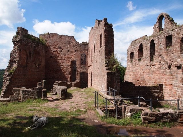
Hohenecken Castle

The remains of the Castle can be visited

Hohenecken Castle (Middle High German: buorch hônecke) is the ruin of a spur castle at 363 m above sea level from the Staufer period, located on the Schlossberg above the Kaiserslautern district of Hohenecken in Rhineland-Palatinate.

The exact founding date of the castle is not known. While older literature often assumes construction directly after the rebuilding of Barbarossa Castle in Kaiserslautern (1156), newer findings suggest a construction start 50 years later. Especially the five-sided keep and the massive shield wall point to a construction period around 1200.

In the first half of the 13th century, the castle was granted as a fief to a ministerial family from Kaiserslautern. These were the descendants of the knight Reinhard von Lautern, who in 1214 had been endowed with the patronage right to Ramstein by King and later Emperor Frederick II. The castle administrators henceforth called themselves von Hohenecken. The castle included a dominion that extended over several settlements: the valley community of Hohenecken, which arose at the foot of the castle hill, as well as Erfenbach, Espensteig, Siegelbach, and Stockweiler, today Stockborn. All of them now belong to the city of Kaiserslautern. The castle and dominion were considered imperial fiefs even centuries later.

With the beginning of the modern era, the decline of Hohenecken Castle began. In the Peasants' War (1525), it was captured by rebellious peasants. In 1668, a prolonged siege by Elector Karl Ludwig of the Palatinate took place, which ended with the partial destruction of the castle. During the Palatinate War of Succession, it was finally blown up by French troops in 1689.

Layout+

The ruin, including the Zwinger, moat, upper and lower castle, measures approximately 50 m by 90 m. It has a mighty shield wall (25 m wide, 11 m high) and a pentagonal keep. Experts consider the castle to be one of the most remarkable castles of the Staufer period. Today it is a popular excursion destination and offers a wide view.

Take Mobile History with you

You are reading this text for free. Premium adds what matters on the road: descriptions read aloud, sites found through your camera, whole regions taken offline.

  • Every description, including the ~17,700 Premium sites
  • Audio guide: have descriptions read to you on location
  • AR finder: see sites through your camera, with distance and bearing
  • Unlimited saved sites

14 days free, then from €2.99 a month. Cancel anytime.

Source: Wikipedia · Licence: CC BY-SA 4.0 · Image: http://www.wehrbauten.de/thread.php?threadid=1502

This description draws on the facts documented in the linked Wikipedia article; Wikipedia content is licensed under CC BY-SA 4.0. Wording and editing: Mobile History.

Location: 49.4147, 7.7014