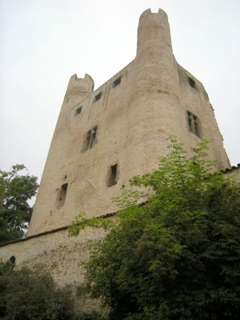
The remains of the Castle can be visited
Hoher Schwarm Castle

The Hoher Schwarm is a castle ruin in the Thuringian city of Saalfeld above the Saale river. An imposing facade on the eastern edge of the old town still remains of the castle today.
The castle was built as a Gothic residential tower castle, whose layout is still clearly recognizable in the present ruin, by the Counts of Schwarzburg on the ground and walls of an older fortification, which was destroyed in 1199 by Landgrave Hermann I, then rebuilt and again razed in 1290 on the order of King Rudolf I.
Since 1208, the former imperial city of Saalfeld belonged to the County of Schwarzburg. The Counts of Schwarzburg rebuilt the destroyed castle at least partially, but probably at the same time also built a more comfortable residential castle, the Kitzerstein ("Könitzerstein"), east of the castle and partly on the city wall. Construction began around 1300. In 1389, the castle was still inhabited and sold to the Wettins along with the lordship of Saalfeld. At that time, it was referred to as Sorbenburg.
Subsequently, the castle continued to serve as an official residence; however, it lost its military significance during the 15th century. When the official residence was moved from the castle to an inner-city building, the castle visibly decayed and was already in a ruinous state by the mid-16th century. In 1551, partial demolition began to obtain building materials. The body of a walled-in girl is said to have been found in the ruins. In 1593, the name Hoher Schwarm appeared for the first time, presumably a shortening of the term "Schworben-/Sorbenburg".
Between 1995 and 1997, the ruin was secured and renovated.
Construction+
The Hoher Schwarm was a tower castle on a square base with a side length of 17 meters. The castle had five stories and presumably four round towers at each corner of the base. Of these, only the two facing the Saale are preserved today. The cellar vaults are walled up. A draw well was found inside the quadrangle.
Today, the Hoher Schwarm houses an open-air stage.
Take Mobile History with you
You are reading this text for free. Premium adds what matters on the road: descriptions read aloud, sites found through your camera, whole regions taken offline.
- Every description, including the ~17,700 Premium sites
- Audio guide: have descriptions read to you on location
- AR finder: see sites through your camera, with distance and bearing
- Unlimited saved sites
14 days free, then from €2.99 a month. Cancel anytime.
Source: Wikipedia · Licence: CC BY-SA 4.0 · Image: http://schloesserrundschau.de/thueringen/schloesser/saalfeldrudol003.html
This description draws on the facts documented in the linked Wikipedia article; Wikipedia content is licensed under CC BY-SA 4.0. Wording and editing: Mobile History.
Location: 50.6473, 11.3664