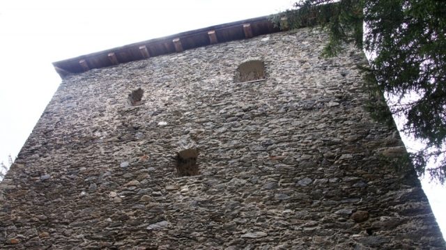
The remains of the Castle can be visited
Klausegg Castle

The ruin of Klausegg Castle is a former border fortification against Styria in Seetal in Lungau. It was built in the Middle Ages by the Archbishops of Salzburg together with a barrier wall dividing the valley. Remains of the castle and the defensive system are still preserved today.
The Klausegg ruin is located not far from the border of the federal states of Salzburg and Styria in Seetal/Lungau on the steep northern slope of the Gstoder at an altitude of approx. 1280 m above sea level, about 70 meters above the valley floor of the Seetal, which extends from Tamsweg about 12 km to the east to the border with Styria, then continues to Seebach, where it flows into the Rantental. The border fortification also represents the easternmost point of today's federal state of Salzburg.
Description of the Buildings+
The complex consists of the castle ruin, fortification wall, and Klausentor (Klaus Gate) including the Passhaus (Pass House) and Klauswirt (Klaus Inn). The wall, which extended from the northern slope of the valley over the Klause for approx. 400 m to the castle on the opposite side of the valley, formed a complete barrier wall that could only be overcome through the Klausentor on the commercial road.
The castle ruin today appears as a box-like three-story building with dimensions of approx. 27 × 12.50 m, with the intermediate ceilings having long since collapsed. The stone building has a height of 16 m and is divided into three parts. It is secured on several sides by a moat.
The ground floor is accessible through the main entrance on the mountain side. Originally, the entrance was on the valley side, but it was later walled up. The walls show a uniform thickness of 2.60 m. The floor plan corresponds to the classic central corridor house. To the left and right of the entrance room are approximately square rooms of approx. 7 × 7.5 m in size. The tripartite division continues on the first floor; on the second floor, which served as a living floor, a dividing wall was omitted, creating a stately living room of 15 × 8 m, which had five valley-side and two east-side bay windows.
The origins of the castle are obscure; its creation can be assumed to be in the period between 1000 and 1200. The construction of the castle itself probably took place in the 13th century. The Archbishops of Salzburg systematically expanded border security to the east according to the "Klause system"; the border with Styria was fortified in Seetal, as well as in Ramingstein and at the Mandling Pass, with a valley barrier. The over 4 m high wall with battlements blocked the entire valley for approx. 400 m at the Klause and connected the castle ("Gschloß") with the Klausentor, where passage was controlled and tolls had to be paid. Next to the gate, the "Passhaus" was built, which served as a toll and guard house. On the Salzburg side of the gate, travelers could refresh themselves in a tavern, which still exists today as the Gasthaus zur Klause. The historic building is the home of Salzburg Archbishop Eduard Macheiner (1907–1972).
The widespread belief that the castle once belonged to the Lords of Pettau and was transferred to Archbishop Eberhard II of Salzburg in 1246 along with the market town of Tamsweg could not be proven. The Klausegg custodianship was entrusted with military tasks. To carry out these tasks, the custodian had a castle guard at his disposal. During the first heyday of Lungau mining, a mountain guard office was also established at Klausegg, which later moved to Moosham. The custodians of Klausegg partly came from the most prominent Lungau noble families; in particular, Mooshaimer and Thannhauser served as custodians of Klausegg. In 1354, for example, Wulfing der Mooshaimer held this office. Especially during the Hungarian Wars at the end of the 15th century, there were repeated military clashes at the fortification, as evidenced by numerous finds. In the 17th century, there were repeated efforts to dissolve the Klausegg custodianship. In 1642, the Salzburg Court Chamber ordered the demolition of the border tower. However, as late as 1680, Martin Jocher was entrusted with the castle guard. The end of the custodianship can be set at the end of the 17th century; the princely custodianship of Klausegg was merged with the main custodianship of Moosham.
In 1712, an imperial office and toll house was built on Styrian territory not far from the Klausentor.
With the abandonment of the custodianship, the castle and the entire defensive system were left to decay. Nature tried to reclaim the terrain it had been wrested from. Parts of the former border wall were demolished and the stones used for other buildings. The decay of the complex progressed rapidly, so that by 1786, Joseph Benedikt Hueber already described the following scene: "On the left hand, on a pleasant hill, the monument of the extinct Klausegg custodianship can still be seen. The walls of this ruined castle are overgrown with fir trees and shrubs at the top, which have a truly ancient appearance."
In 1999, the ruin and the border wall were restored. The parts of the wall worth preserving were sealed and provided with a protective roof. On the initiative of the Seetal elementary school, a legend hiking trail was created, leading from the Gasthaus zur Klause to the ruin.
Legends+
Various legends surround the overgrown fortification; it is said to be haunted. The souls of violent robber knights from the "Klausegger" family are said to haunt the ruins at night and await their redemption. A nearly vertically sloping tunnel located about 100 m west of the ruin is said to be the exit of an underground escape route from the castle. According to legend, a flickering light can be seen there on some nights, commemorating a castle guard who met a violent death there.
Take Mobile History with you
You are reading this text for free. Premium adds what matters on the road: descriptions read aloud, sites found through your camera, whole regions taken offline.
- Every description, including the ~17,700 Premium sites
- Audio guide: have descriptions read to you on location
- AR finder: see sites through your camera, with distance and bearing
- Unlimited saved sites
14 days free, then from €2.99 a month. Cancel anytime.
Source: Wikipedia · Licence: CC BY-SA 4.0 · Image: http://www.wehrbauten.at
This description draws on the facts documented in the linked Wikipedia article; Wikipedia content is licensed under CC BY-SA 4.0. Wording and editing: Mobile History.
Location: 47.1552, 13.9622