CastleNeumarkt im Mühlkreis

Kronest Castle
Kronest Castle

The remains of the Castle can be visited

The castle ruin Kronest (also: Bibrachstein) is located approximately two kilometers north of Neumarkt in the Mühlviertel region of Upper Austria. Kronest Castle was first mentioned in a document around 1334, and by 1609 it was no longer inhabited.

The first documented mention dates back to 1334, when Friedrich Schrautolf, the regional judge of Machland zu Freistadt, received permission from the sovereign to build a castle at this location. Since the land belonged to St. Florian Abbey, he had to pay ten pfennigs in tax to the abbey annually. Additionally, he had to hand over a farmstead as compensation. In 1377, Hans der Lasberger bought the castle (Chranest) and also paid the tax to the abbey. The designation at that time was Schrautolf's Tower, which indicates a former residential tower (turris Schrautolfi). During the Hussite Wars, the castle was damaged, and the defensive tower burned down around 1428. The current name Kronest, meaning "crow's nest," emerged around this time.

Around 1455, a Caspar von Alharting was named as owner. In 1508, the castle was a sovereign fief. In 1527, Veit von Zelking sold half of the castle to the Piberhof and united the castle with the dominion of Weinberg. In the same year, the castle was sold to the Thürheimer family, who acquired Weinberg Castle after the Counter-Reformation. The Thürheimers referred to the castle as Bibrachstein, named after "Bibrachzell" Castle (today "Biberachzell," a district of Weißenhorn in the Neu-Ulm district of Bavarian Swabia), one of their ancestral castles. The latter designation did not prevail.

During the Hussite Wars, Kronest is likely to have been destroyed and burned down. The reddish discoloration on the inside indicates that the fortified residence was destroyed by an explosive fire. The last documented mention dates from 1602, when Kronest is described as a desolate "Stöckl" (small building). Since then, the castle has steadily decayed and is now only a ruin.

Kronest Today+

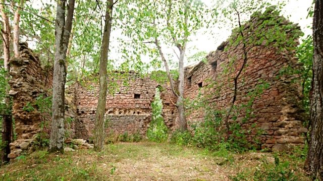
The building is situated on a low rocky outcrop near the village of Kronast. The ruin is not visible from the road in Kronast, as the castle hill is now completely overgrown with trees and shrubs. If one walks from the tennis court towards the small hill to the south, one will come across the masonry.

Today, three outer walls of the castle are still visible; the east wall, the former entrance, has completely disappeared. The castle was more of a residential complex than a defensive structure. Only the entrance was five meters high to provide protection. The castle could not withstand a siege, hence its partial destruction during the Hussite Wars. The castle had a square footprint of 144 square meters with walls 12 meters long each. The wall thickness on the ground floor was one meter, and on the first floor, about 80 centimeters. Local farmers used stones for their houses, thus contributing to the demolition of the castle.

The still visible beam holes indicate the former two floors including the attic. In the past, a passage was said to have led from the castle's cellar into the forest to an underground well; in addition to providing water, this passage served as an escape route.

Take Mobile History with you

You are reading this text for free. Premium adds what matters on the road: descriptions read aloud, sites found through your camera, whole regions taken offline.

  • Every description, including the ~17,700 Premium sites
  • Audio guide: have descriptions read to you on location
  • AR finder: see sites through your camera, with distance and bearing
  • Unlimited saved sites

14 days free, then from €2.99 a month. Cancel anytime.

Source: Wikipedia · Licence: CC BY-SA 4.0 · Image: http://www.wehrbauten.at

This description draws on the facts documented in the linked Wikipedia article; Wikipedia content is licensed under CC BY-SA 4.0. Wording and editing: Mobile History.

Location: 48.4531, 14.4761