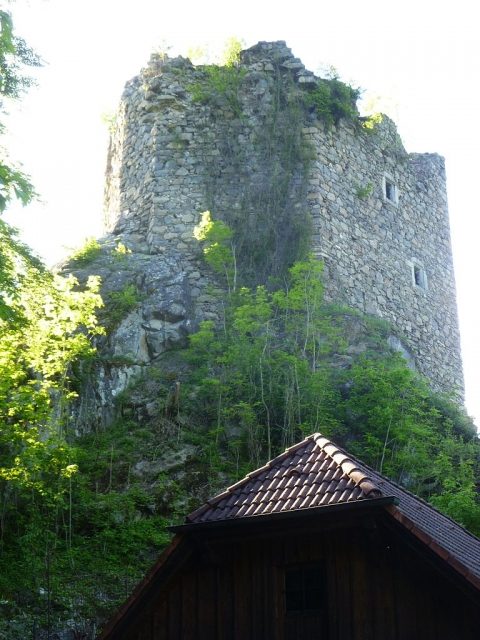
CastleGramastetten

Lichtenhag Castle

Lichtenhag Castle

To be privately owned

Lichtenhag Castle Ruin, historically also Liechtenhaag Castle, is located in the municipality of Gramastetten in the Mühlviertel region of Upper Austria. Its first documented mention was in 1167. After the castle was merged with other lordships under the Starhembergs, it began to fall into disrepair. The ruin is now privately owned.

Location+

The former hilltop castle is situated halfway up a mountain ridge that slopes steeply into the valley of the Große Rodl, at an elevation of 470 m above sea level. The complex belongs to the village of Lichtenhag, which shares its name, in the market town of Gramastetten, from whose town center the former castle is located approximately one kilometer to the west as the crow flies.

Description+

The small former castle has an irregularly triangular floor plan. The total area enclosed by the ring wall is 1,100 square meters. The complex consisted of servants' quarters and a mighty, pentagonal, and once five-story residential and defensive tower with Gothic gate and window frames. These buildings are now ruins. A residential house belonging to the complex in front of the ruin is still inhabited.

The first documented mention of the complex dates from July 14, 1167. The owners at that time were Leuthart and Chunrad de Hage. The Hager family later bore the surname Aspan von Lichtenhag and remained in possession of the Lichtenhag lordship until 1615. On March 8, 1615, the castle was sold to Wolf von Gera. In 1615, the castle was described as follows: Liechtenhag, which was somewhat poor in terms of roofing, [...] has a large spacious room and a small one on the upper floor; on the lower floor also a spacious room and chamber along with a kitchen and cellar, outside the castle stables for 10 horses, rooms and chambers near the gate. At that time, the Lichtenhag lordship also included forest, hunting rights, Fischbach, a manor farm, some plots of land, and 47 subjects. However, by the middle of the 17th century, the castle was only inhabited by residents. In 1654, Lichtenhag Castle, along with Eschelberg and Waxenberg castles, was purchased by Konrad Balthasar Starhemberg. The lordships were merged and administered from Eschelberg. The Lichtenhag castle buildings were left to decay; by around 1674, the residential tower was already a ruin (cf. engraving by G. M. Vischer).

Since 1954/55, monument preservation measures have been implemented to protect the residential tower from further decay. In 1964, the castle ruin was purchased by Kurt Wöss, and the annex was converted into a weekend residence. Since 1978, the castle ruin has been owned by the Doblhofer family. The ruin is not generally accessible.

Lichtenhag Castle Ruin, historically also Liechtenhaag Castle, is located in the municipality of Gramastetten in the Mühlviertel region of Upper Austria. Its first documented mention was in 1167. After the castle was merged with other lordships under the Starhembergs, it began to fall into disrepair. The ruin is now privately owned.

Location+

The former hilltop castle is situated halfway up a mountain ridge that slopes steeply into the valley of the Große Rodl, at an elevation of 470 m above sea level. The complex belongs to the village of Lichtenhag, which shares its name, in the market town of Gramastetten, from whose town center the former castle is located approximately one kilometer to the west as the crow flies.

Description+

The small former castle has an irregularly triangular floor plan. The total area enclosed by the ring wall is 1,100 square meters. The complex consisted of servants' quarters and a mighty, pentagonal, and once five-story residential and defensive tower with Gothic gate and window frames. These buildings are now ruins. A residential house belonging to the complex in front of the ruin is still inhabited.

The first documented mention of the complex dates from July 14, 1167. The owners at that time were Leuthart and Chunrad de Hage. The Hager family later bore the surname Aspan von Lichtenhag and remained in possession of the Lichtenhag lordship until 1615. On March 8, 1615, the castle was sold to Wolf von Gera. In 1615, the castle was described as follows: Liechtenhag, which was somewhat poor in terms of roofing, [...] has a large spacious room and a small one on the upper floor; on the lower floor also a spacious room and chamber along with a kitchen and cellar, outside the castle stables for 10 horses, rooms and chambers near the gate. At that time, the Lichtenhag lordship also included forest, hunting rights, Fischbach, a manor farm, some plots of land, and 47 subjects. However, by the middle of the 17th century, the castle was only inhabited by residents. In 1654, Lichtenhag Castle, along with Eschelberg and Waxenberg castles, was purchased by Konrad Balthasar Starhemberg. The lordships were merged and administered from Eschelberg. The Lichtenhag castle buildings were left to decay; by around 1674, the residential tower was already a ruin (cf. engraving by G. M. Vischer).

Since 1954/55, monument preservation measures have been implemented to protect the residential tower from further decay. In 1964, the castle ruin was purchased by Kurt Wöss, and the annex was converted into a weekend residence. Since 1978, the castle ruin has been owned by the Doblhofer family. The ruin is not generally accessible.

Take Mobile History with you

You are reading this text for free. Premium adds what matters on the road: descriptions read aloud, sites found through your camera, whole regions taken offline.

  • Every description, including the ~17,700 Premium sites
  • Audio guide: have descriptions read to you on location
  • AR finder: see sites through your camera, with distance and bearing
  • Unlimited saved sites

14 days free, then from €2.99 a month. Cancel anytime.

Source: Wikipedia · Licence: CC BY-SA 4.0 · Image: http://commons.wikimedia.org/wiki/File:Lichtenhag-1.jpg

This description draws on the facts documented in the linked Wikipedia article; Wikipedia content is licensed under CC BY-SA 4.0. Wording and editing: Mobile History.

Location: 48.3794, 14.1756