CastlePforzheim - Würm

Liebeneck Castel
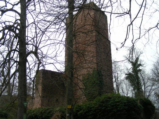
Liebeneck Castel

The remains of the Castle can be visited

The Liebeneck Castle Ruin is the ruin of a high medieval spur castle in the southwestern part of the Heckengäu, a forest area southeast of the Würm district of Pforzheim in Baden-Württemberg.

The castle ruin is located on a hill above the Würm with a view over the Würmtal. It lies in a protected forest at 415m above sea level. The Liebeneck ruin cannot be reached by car; only forest paths (e.g., the Ostweg) lead there.

The original castle complex was probably built in the 12th century. The first documented mention occurred in 1236 on the occasion of the transfer of the castle and the village of Würm from the Lords of Weißenstein zu Kräheneck to Margrave Rudolf of Baden. The castle was intended to protect the raft toll station established on the river. Later, the castle became a hereditary fief of the Lords of Weißenstein and then came into the possession of the Lords Leutrum von Ertingen.

In 1692, during the War of the Palatine Succession (Orleans'schen Krieg), the castle burned down. In 1828, it was transferred to the Baden state. The complex was subsequently systematically destroyed so that "riff-raff would not find shelter there" (see information board). Between 1968 and 1977, the 30m high keep was renovated.

Complex+

Of the original complex, the keep and some walls enclosing the castle courtyard still stand. The double pentagonal wall ring with its outworks and Zwinger (outer baileys) characterize this archaeological monument. The ruin has been secured by the building authority. Detailed information can be found on an orientation board directly at the ruin.

Take Mobile History with you

You are reading this text for free. Premium adds what matters on the road: descriptions read aloud, sites found through your camera, whole regions taken offline.

  • Every description, including the ~17,700 Premium sites
  • Audio guide: have descriptions read to you on location
  • AR finder: see sites through your camera, with distance and bearing
  • Unlimited saved sites

14 days free, then from €2.99 a month. Cancel anytime.

Source: Wikipedia · Licence: CC BY-SA 4.0 · Image: http://www.wehrbauten.de/thread.php?threadid=1587

This description draws on the facts documented in the linked Wikipedia article; Wikipedia content is licensed under CC BY-SA 4.0. Wording and editing: Mobile History.

Location: 48.8379, 8.7518