CastleBad Honnef

Löwenburg Castle

Löwenburg Castle

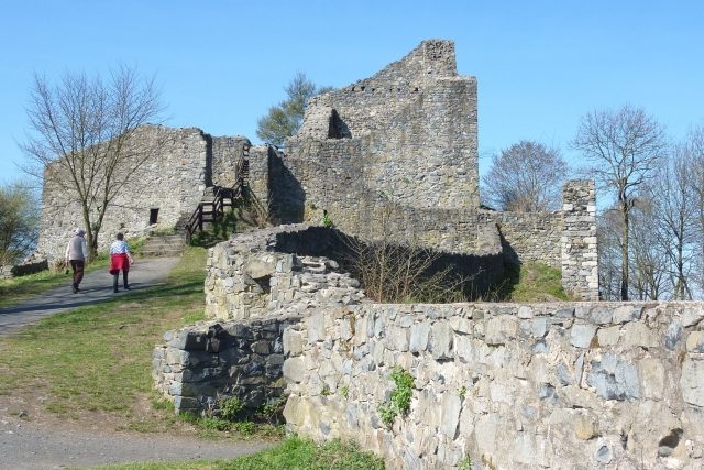
The remains of the Castle can be visited

The Löwenburg is the ruin of a medieval hilltop castle on the 455 m high mountain of the same name in the Siebengebirge. It belongs to the urban area of Bad Honnef in the Rhein-Sieg-Kreis, North Rhine-Westphalia. Due to the exposed location of the ruin with views over the Rhine Valley near Bonn and the front Westerwald, it is one of the most popular hiking destinations in the Siebengebirge.

The Löwenburg was built in the second half of the 12th century by Heinrich II, Count of Sayn, who had advanced from the Westerwald, as a border fortress against the Electoral Cologne castles of Drachenfels and Wolkenburg. It was first mentioned in a document on August 29, 1247, as castrum Lewinberg during the division of the Sayn inheritance by Countess Mechthild von Sayn, who reserved the right to reside in the castle. The main castle, outer bailey, and the northern outer ring were built in the 13th century. Through inheritance, the castle passed in 1269 to Mechthild's nephews, a line of the Counts of Sponheim-Heinsberg, who from then on called themselves Lords of Löwenburg. The main town of their dominion became Honnef.

As a result of numerous changes of ownership, the castle fell to the Duchy of Jülich-Berg in 1484 and formed the Löwenburg office, which was administered from the castle until the middle of the 16th century.

The military campaigns at the end of the 16th century, from which the Löwenburg office particularly suffered, led to its ruin. From then on, the elongated hilltop castle complex of the 13th century with its keep, bailey, and outer bailey increasingly decayed. Preserved are the cistern in the castle courtyard and two side walls of the former keep of the main castle with base dimensions of ten by ten meters. The keep itself was partially removed in 1832 – and completely in 1881 – due to dilapidation, after an initiative to preserve and renovate the ruin had previously failed.

In 1861, a predecessor of today's State Forestry Office Siegburg, the Royal Prussian Chief Forestry Office Siebengebirge, took over the administration of the ruin site. In 1862, individual restoration works were carried out, and in the years 1897–1901, the largest part of the existing structure was secured. In July 1906, an observation tower was built at the highest point of the castle. At the beginning of the Second World War, in 1939, an observation post for anti-aircraft defense was erected on the upper castle. During the fighting for the Rhine crossing of the American troops, the Löwenburg came under heavy fire, which presumably also destroyed the observation tower built in 1906.

With the dissolution of the state of Prussia, the Löwenburg became state forest property of North Rhine-Westphalia in 1947. In 1951, the castle ruin was largely dilapidated and overgrown, and the ascent to the summit via most footpaths was severely hampered. To increase the significantly reduced tourist value of the Löwenburg again, the Siebengebirge Beautification Association planned in 1951 to open the road from Schmelztalstraße via Einsiedeltal to the castle ruin for motor vehicle traffic. Today there is a driveway from Margarethenhöhe.

From 1979 to 1985, the State Forest Administration, with the participation of the State Building Office Bonn, carried out extensive securing and restoration work. The remaining foundations of the castle complex were uncovered and secured. Several panels show the original appearance of the castle. The Rheinisches Landesmuseum accompanied the excavations.

Take Mobile History with you

You are reading this text for free. Premium adds what matters on the road: descriptions read aloud, sites found through your camera, whole regions taken offline.

  • Every description, including the ~17,700 Premium sites
  • Audio guide: have descriptions read to you on location
  • AR finder: see sites through your camera, with distance and bearing
  • Unlimited saved sites

14 days free, then from €2.99 a month. Cancel anytime.

Source: Wikipedia · Licence: CC BY-SA 4.0 · Image: Joachim Schneeleopard

This description draws on the facts documented in the linked Wikipedia article; Wikipedia content is licensed under CC BY-SA 4.0. Wording and editing: Mobile History.

Location: 50.6641, 7.2504