CastleEssen - Bredeney

Neu-Isenburg Castle
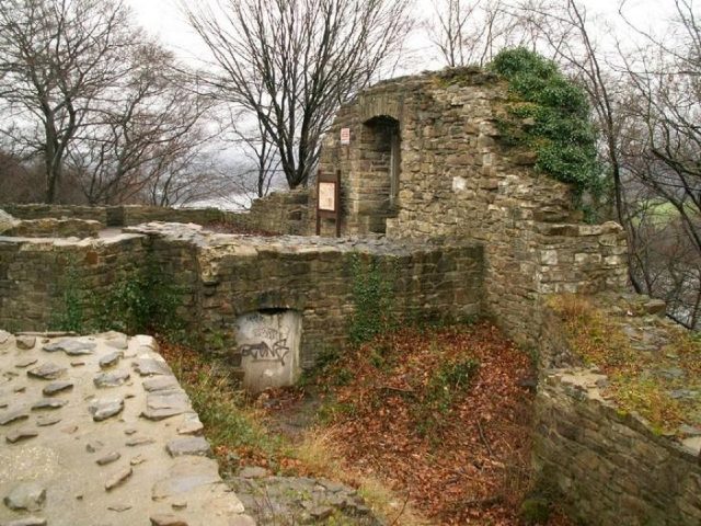
Neu-Isenburg Castle

The remains of the Castle can be visited

The Neue Isenburg is a castle ruin in the Bredeney district of Essen. It is named after the Hattingen Isenburg, which was destroyed in 1226.

The complex was built around 1240 by Count Dietrich von Altena-Isenberg on a approximately 150-meter high mountain spur of the Bremberg above the Ruhr. The rocky castle area is bordered to the east and west by deep stream valleys and on the south side by a steep slope leading down to Lake Baldeney. The castle was thus easy to defend and also had a strategically favorable location near the Cologne Road and the Hellweg.

However, only 48 years after its construction, the castle was destroyed again and subsequently fell into ruin. At the beginning of the 20th century, hardly any above-ground traces of it were visible. Only an excavation between 1927 and 1933 uncovered the visible structural remains again.

The Neue Isenburg is owned by the City of Essen and is protected as a building and archaeological monument. The ruin is freely accessible and can be visited free of charge.

Dietrich's father, Friedrich von Isenberg, was executed in November 1226 for the killing of the Archbishop of Cologne, Engelbert von Berg. His castles, including the Isenburg in Hattingen, were destroyed, and the Isenberg possessions were confiscated and divided between the Archdiocese of Cologne and the Counts of the Mark. This not only changed land ownership and feudal rights, but also transferred the lucrative vogteien (advocacies) over the wealthy imperial abbeys of Werden and Essen from the Isenbergs to Electoral Cologne.

However, Dietrich, as Friedrich's eldest son, demanded the return of all possessions, including the lost rights, from about 1230 onwards. This sparked the so-called Isenberg Feud between him and his uncle Heinrich IV of Limburg on one side, and Count Adolf I of the Mark together with the Archbishop of Cologne Konrad von Hochstaden on the other.

To assert his hereditary claim to the patronage over the abbeys of Essen and Werden, he had the "new" Isenburg built on Werden's land around 1240. Excavation finds, such as pottery shards, have shown that the rocky spur was already settled in earlier times.

In 1243, the feud ended, and Dietrich regained part of his father's possessions. However, since the Archbishop did not want to give up the lucrative vogteien, he had the "castrum Hisinbergh" besieged in 1244 and was able to conquer it. Konrad von Hochstaden then appointed Heinrich von Sayn as castellan, who represented Cologne's interests from the Isenburg. The complex was used as a bastion in the fight against the Counts of the Mark and as a prison. Prominent prisoners included Bishop Simon I of Lippe of Paderborn and Count Adolf I of Waldeck.

On February 22, 1248, Dietrich von Isenberg renounced his rights to the castle and the vogteien over Essen and Werden in favor of Cologne and retreated to his Limburg near Hagen. Subsequently, the Neue Isenburg served as an administrative seat and military base for the Archdiocese of Cologne.

After Siegfried von Westerburg's defeat in the Battle of Worringen, one of the victors, Count Eberhard I of the Mark, exploited Electoral Cologne's weakness to conquer several Cologne possessions, including the Neue Isenburg, which he had razed in 1288. It was not rebuilt thereafter.

The complex increasingly fell into ruin. Around 1900, only a few wall remnants were visible, most of it buried under earth and rubble. An excursion restaurant was set up in the core castle area.

Under the direction of Ernst Kahrs, then head of the Ruhrlandmuseum, the visible structural remains were uncovered and partially re-walled between 1927 and 1933. From 1975 to 1979, at the initiative of Leo Fonrobert, then director of the Essen Stadtwald-Gymnasium, smaller preservation works and excavations followed, partly as a project of the gymnasium, whose finds are now exhibited in the Ruhr Museum.

Description+

With dimensions of approximately 135 by 45 meters, the Neue Isenburg was one of the largest castle complexes in the region. It was built entirely from Ruhr sandstone, which was quarried directly from the castle rock. Its buildings were almost completely surrounded by a moat, in which two wells were located on the north side.

The complex is divided into an outer bailey and a core castle, separated by a four to five meter deep and ten meter wide moat. A modern wooden bridge now replaces the former drawbridge, which previously formed the only access to the main castle. A total of 15 rock-cut stairs connected the buildings and terraced castle sections. However, only three of them remain.

Outer Bailey

The outer bailey area measures approximately 45 by 75 meters and is surrounded by an approximately 180-meter long ring wall, up to two meters thick. Its gatehouse is located in the northeastern corner and is only partially preserved. In the northwestern corner, the 4.5-meter high remains of an eight-meter wide tower with a horseshoe-shaped floor plan still exist. It was one of a total of eight towers protecting the complex.

The half-timbered house standing in this area was only built in the 20th century.

Core Castle

The core castle has an oval floor plan with dimensions of approximately 45 by 37 meters. Its ring wall has a thickness of up to two meters. A zwinger (outer ward) is positioned in front of it towards the outer bailey as additional protection for the entrance.

Along the inside of the ring wall, several buildings were grouped around an inner courtyard, of which mostly only foundations remain. In the southwestern corner stand the remnants of the square main tower with a side length of 8.75 meters. The 1.8-meter thick walls must once have been at least 20 meters high.

To the east of the keep, there was formerly a narrow building, whose cellar is still preserved. The building served as a connection to the former three-story palas. A staircase led to its entrance, which was slightly above the level of the inner courtyard. The ground floor was occupied by two rooms, the larger of which had three still preserved window niches. Its ceiling was supported by a central column, of which stone remnants of this support bear witness.

Adjoining the palas to the east are the stumps of the walls of a narrow outbuilding, whose purpose has not yet been clarified; both use as an economic building and as a residential building are conceivable. A staircase leads to its cellar floor.

The third well of the castle complex is located on the northern side of the courtyard and has been reconstructed today.

Take Mobile History with you

You are reading this text for free. Premium adds what matters on the road: descriptions read aloud, sites found through your camera, whole regions taken offline.

  • Every description, including the ~17,700 Premium sites
  • Audio guide: have descriptions read to you on location
  • AR finder: see sites through your camera, with distance and bearing
  • Unlimited saved sites

14 days free, then from €2.99 a month. Cancel anytime.

Source: Wikipedia · Licence: CC BY-SA 4.0 · Image: http://www.wehrbauten.de/thread.php?threadid=575

This description draws on the facts documented in the linked Wikipedia article; Wikipedia content is licensed under CC BY-SA 4.0. Wording and editing: Mobile History.

Location: 51.4103, 7.0311