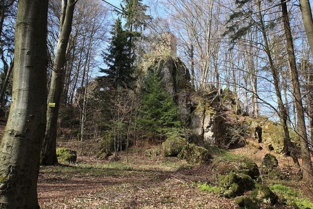
The remains of the Castle can be visited
Poppberg Castle
The castle ruin Poppberg is a well-preserved former high to late medieval noble castle near the village of Poppberg in the municipality of Birgland in the Upper Palatinate district of Amberg-Sulzbach in Bavaria. The castle ruin is freely accessible at all times.
The ruin of Poppberg Castle is located in the Franconian Jura on the rocky summit of the high Poppberg, about 600 meters west-northwest of the church of the village of Poppberg, which shares its name, in the municipality of Birgland and about 20 kilometers west of the city of Amberg.
In the immediate vicinity is the presumed Leherfels motte on the neighboring Leherberg. Three kilometers east-northeast is another motte on the Hagfelsen near the village of Burkartshof, which may have been a predecessor of Poppberg Castle.
Within sight lies the former Habsberg Castle, now a motte, on which the pilgrimage church of Mariä Himmelfahrt stands today.
The two-part hilltop castle was probably built in the 13th century by the Counts of Sulzbach and mentioned in the possession of Emperor Charles IV from 1353 to 1373. After the castle fell to Margrave Otto of Brandenburg, it came to the Bavarian Dukes Johann and Stephan in 1379, who sold it to Count Palatine Ruprecht III in 1395. In 1505, the castle was incorporated into the Duchy of Sulzbach and the land sold to farmers in 1550. After the castle fell into disrepair, the ruin came to the Bavarian state in 1791 and is now in private ownership.
Architectural Description+
The former Poppberg Castle stood on the highest point of the freestanding conical Poppberg, which slopes moderately steeply by about 60 meters on all sides. The castle was built on a rocky plateau at the summit. Around the castle ruin, the slopes of the Poppberg are heavily interspersed with rocks, making approach difficult despite the only moderate incline. The plateau has an area of about 75x45 meters and a roughly rectangular layout.
The castle complex consisted of a main castle and an outer bailey-like courtyard, enclosed by a common curtain wall adapted to the rocky step of the plateau edge. The castle path came from the west, passed the southwest corner of the castle complex, on which a wall tower stood, and led into the former castle gate approximately in the middle of the south side. The gate led into the area of the outer bailey located on the east side of the complex, of which only the unsecured and therefore threatened remains of the curtain wall are preserved. Uneven terrain could indicate former buildings that leaned against the curtain wall.
The area of the main castle, which was separated only by a simple wall, adjoined the outer bailey directly to the west.
In the northern part of the core castle stood the very well-preserved palas. The main building had a rectangular floor plan and was about 25 meters long and 12 meters wide. Like the rest of the castle complex, it consisted of roughly hewn rubble masonry. Only at the southeast corner of the building were more carefully worked bossed ashlar blocks used. They were broken out up to a height of about three meters and presumably used for the construction of buildings in the surrounding area. Whether bossed ashlar blocks were also used at the other corners is not known, as the outer walls are missing on the west and north sides. The main building probably had a tower-like form.
Three floors are still preserved, at least one more is to be assumed. The current access is half-buried and formerly led to a basement, followed by an unlit mezzanine. The actual living area was on the third floor of the palas and had three accesses. On the southern long side towards the castle area, there was probably the main entrance, which was accessible by a staircase. At the southwest and northeast corners, two further accesses led to the battlements of the curtain wall built onto the palas. Window openings are also present on this floor.
On the southwest side, a tower had been erected on a pointed rock, the highest point of the castle. This defensive tower is not to be considered a keep; its small dimensions argue against it. However, it was cleverly integrated into the castle complex; from it, a large part of the castle path and the gate could be overlooked and covered. The interior area of the castle could also be partially surveyed from there. The tower had a square floor plan and projected from the curtain wall on the south and west sides in its full width. Its south and east sides are still preserved, almost the entire outer masonry is missing on the west side, and the north side is completely missing. Its tip, at about four meters high, is now covered with bricks. An anti-aircraft position was located there during World War II.
Take Mobile History with you
You are reading this text for free. Premium adds what matters on the road: descriptions read aloud, sites found through your camera, whole regions taken offline.
- Every description, including the ~17,700 Premium sites
- Audio guide: have descriptions read to you on location
- AR finder: see sites through your camera, with distance and bearing
- Unlimited saved sites
14 days free, then from €2.99 a month. Cancel anytime.
Source: Wikipedia · Licence: CC BY-SA 4.0 · Image: http://de.wikipedia.org/wiki/Datei:Burgruine-Poppberg03.JPG
This description draws on the facts documented in the linked Wikipedia article; Wikipedia content is licensed under CC BY-SA 4.0. Wording and editing: Mobile History.
Location: 49.4134, 11.5839