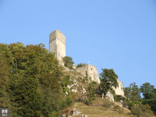
The remains of the Castle can be visited
Randeck Castle

Randeck Castle is now only a ruin, and is located on the northern valley edge of the Altmühl on a rocky outcrop above the market town of Essing in the Lower Bavarian district of Kelheim in Bavaria.
The hilltop castle is inextricably linked with the market town of Essing at its feet. The people of Essing had to perform feudal services for their lord of the castle.
The first fortification at this location probably originated as early as the 10th century under Duke Arnulf I of Bavaria to protect against Hungarian invasions. The current castle was built in the 11th and 12th centuries by the Randeckers. In 1298, it fell to the Abensberger Babonen, notorious as robber knights, and after their extinction in 1485, finally to the Duchy of Bavaria. Already in 1529, it fell to Lord Leonhard von Eck, in 1565 Otto Heinrich von Schwarzenberg bought the castle, then in 1594 Alexius Fugger. In 1596, Duke Wilhelm of Bavaria acquired the castle, but immediately exchanged it with Johann Wolf Freymann for his Mühlfelden Castle. During the Thirty Years' War, Randeck Castle was severely damaged by Swedish troops in 1634. In 1672, the Jesuit College of Ingolstadt bought the castle. After the dissolution of the order in 1773, it again fell to Bavaria – which had by then become an Electorate. In 1776, the Order of Malta acquired the complex.
In 1818, the castle fell to the Kingdom of Bavaria. In 1838, parts of the castle collapsed, including the keep. Already in 1842, Crown Prince Maximilian of Bavaria had the complex secured and partially rebuilt. In 1975, it was extensively renovated and has since been a tourist attraction. The ruin is now owned by the market town of Essing.
Description+
Of Randeck Castle, essentially only some outer walls, the castle dungeon, the windowless hunger tower, and the 36-meter-high keep, very accurately constructed from regular ashlar blocks, remain today. Originally, the complex is said to have had nine rooms, eight chambers, three kitchens, a castle chapel dedicated to Saint George, a cellar, and a draw well.
Take Mobile History with you
You are reading this text for free. Premium adds what matters on the road: descriptions read aloud, sites found through your camera, whole regions taken offline.
- Every description, including the ~17,700 Premium sites
- Audio guide: have descriptions read to you on location
- AR finder: see sites through your camera, with distance and bearing
- Unlimited saved sites
14 days free, then from €2.99 a month. Cancel anytime.
Source: Wikipedia · Licence: CC BY-SA 4.0 · Image: Mobile Geschichte
This description draws on the facts documented in the linked Wikipedia article; Wikipedia content is licensed under CC BY-SA 4.0. Wording and editing: Mobile History.
Location: 48.9380, 11.7896