CastleRastenberg

Raspenburg Castle

Raspenburg Castle

The remains of the castle can be visited

The Raspenburg is a castle ruin in the town of Rastenberg in the Sömmerda district in northeastern Thuringia.

The castle complex is located on the northeastern outskirts of Rastenberg on a northwest-facing mountain spur, which offered natural protection due to its steep drop. The castle gained strategic importance due to its location on an old road over the Finne.

The area around Rastenberg, Freyburg, and Naumburg came into the possession of Louis the Springer shortly after 1085 through his marriage to Adelheid († 1110), the widow of the murdered Count Palatine Frederick III of Goseck, who had his own castles built here shortly thereafter. This significantly solidified his newly acquired position in the Saale-Unstrut region.

The "Castrum Raspinberg" was a residence of Henry Raspe III (1155–1180) from the Ludowingian dynasty. The last Ludowingian, Henry Raspe IV (1204–1247), also owned the castle. The Raspenburg was designed for permanent defense in the Landgraviate of Thuringia. At the same time, it belonged to the network of station castles (Creuzburg, Dryburg, Tenneberg, Runneburg, Eckartsburg, and others) which served in many ways as accommodation, but primarily for the administration and defense of the Landgraviate. Here, noble families from neighboring towns were employed as burgmannen and ministerials. In the Thuringian-Hessian War of Succession, which broke out after the death of Henry Raspe IV, a collateral line of the Counts of Kevernburg, the Counts of Rabenswalde, initially took control in Rastenberg. From 1288, the Wettins, who had established themselves in West Thuringia as successors to the Ludowingians and Landgraves of Thuringia, also took over the Raspenburg. With the sale of the Landgraviate by Landgrave Albrecht to King Adolf of Nassau, his sons Frederick and Dietzmann had been bypassed, which led to bloody battles throughout the Wettin dominion, in which the king himself intervened in 1294 and drove out Albrecht's sons during a campaign. The castle then changed hands several times and degenerated into a robber baron's nest. In 1324, it was besieged by Frederick the Bitten with the help of the imperial cities of Mühlhausen and Erfurt and destroyed after the expulsion of the castle garrison. The castle ruin, with its associated land, was received by the Counts of Orlamünde as a Wettin fief and partially renovated. In 1378, the village of Rastenberg was elevated to a town by the Wettins; the castle was now part of the town's fortifications. Remains of the castle were still used as a defensive position until 1525. During the partitions of the country in 1485 and 1572, Rastenberg became part of the Weimar line. Militarily insignificant, the castle complex fell into disrepair. It became a supplier of stones for the town's buildings, especially after 3 town fires during the Thirty Years' War. In 1804, the castle hill came into the possession of the town.

More Recent Times+

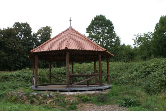
The Rastenberg town council had the castle plateau cleared and planted lime trees along the edge and fruit trees in the former castle courtyard area. The first attempts at excavation date back to 1856. Attempts at construction with historicizing architectural forms were rejected in 1933 by the Weimar district building authority. After decades of quiet, the castle tower was uncovered again in 1994. In cooperation with the Friedrich Schiller University Jena, the entire castle hill was geoelectrically surveyed and mapped in 1994 and 1995. This revealed the size of the castle. With the possibilities of the LEADER program and with the support of the local working group "Northern Sömmerda District," the project was resumed in 2004 and completed in 2005. The area was cleared of bushes, old fruit trees were removed, the tower hole was cleared of rubble, and an information pavilion was erected on the tower stump. Thus, the remaining tower is secured, and an information and resting point has been created. The area is now used for festivals and events.

Layout+

The original castle complex was extensively laid out and divided into a main castle and an outer bailey area, which were jointly secured against the mountain by a staggered rampart-ditch fortification. To the north, west, and east, the existing steep slope offers natural protection. Apart from the tower uncovered in the main castle, hardly any wall remains are visible.

Take Mobile History with you

You are reading this text for free. Premium adds what matters on the road: descriptions read aloud, sites found through your camera, whole regions taken offline.

  • Every description, including the ~17,700 Premium sites
  • Audio guide: have descriptions read to you on location
  • AR finder: see sites through your camera, with distance and bearing
  • Unlimited saved sites

14 days free, then from €2.99 a month. Cancel anytime.

Source: Wikipedia · Licence: CC BY-SA 4.0 · Image: Roland Neubert, Halle (Saale)

This description draws on the facts documented in the linked Wikipedia article; Wikipedia content is licensed under CC BY-SA 4.0. Wording and editing: Mobile History.

Location: 51.1783, 11.4217