CastleBetzenstein-Riegelstein

Riegelstein Castle
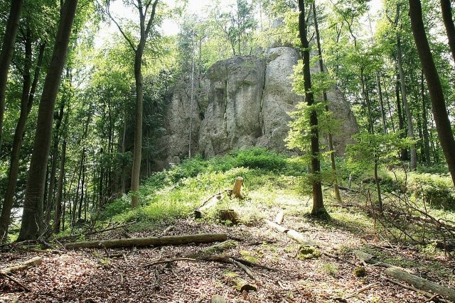
Riegelstein Castle

The remains of the castle can be visited

The castle ruin Riegelstein is a former high medieval noble castle north of the church village of Riegelstein in the municipality of Betzenstein in the Upper Franconian district of Bayreuth in Bavaria, Germany. Of the vanished ridge castle, only two moats and a few unsecured wall remains are still present, which are threatened by complete disappearance.

The castle ruin is located in the southeastern Franconian Switzerland, a part of the Franconian Alb, on the highest point of the Riegelstein Schlossberg at 589 m above sea level. The ruin is located about 360 meters north-northeast of the Evangelical-Lutheran branch church of St. George in Riegelstein, formerly Raupersdorf, and about 32 kilometers northeast of Nuremberg.

It can be reached from the village of Riegelstein by following the footpath that runs west alongside the Bundesautobahn 9. At the highest point of the path, shortly after the village, one must continue off-path up the mountain. At the top, one encounters a poor forest path that, going north, ends at the neck ditch of the castle. To reach the upper castle, one must climb onto the rock reef.

Nearby are other former medieval castles; on the immediately adjacent Schweinsberg lies an unknown castle site, while to the west and northwest are the former castles of Spies, Strahlenfels, and Wildenfels. On the 550-meter-high castle site located 1.4 kilometers north, lies the so-called Burgstall im Eibental, and another completely unknown castle site on the Hühnerstein three kilometers away to the northwest.

Johann Christoph Stierlein produced a scaled topographical map of the castle ruin and its immediate surroundings in 1792. Various wall courses and a well or cistern are clearly visible.

History of the Castle+

When the castle was built is not precisely known, but according to the Nuremberg castle researcher Hellmut Kunstmann, based on ceramic finds dated by him, it could have been around the year 1200. Who built the castle is also unknown. The Lords of Türriegel, belonging to the lower nobility, are probably not to be regarded as castle founders; they resided as minor servants of the Schenken von Reicheneck in smaller manor houses in the Hammerbach valley near Engelthal. According to Gustav Voit, however, Riegelstein Castle was only built around 1360 by the Türriegel family.

The first documentary mention of the Lords of Türriegel occurred with Heinricus Türrigl shortly before 1260; he was then a witness for Walter Schenk von Klingenburg. The Klingenburgers were at that time the lords of Reicheneck Castle. The Türriegel were mentioned several times later, residing in Eschenbach and Simmelsdorf.

Riegelstein Castle itself was first mentioned in a document around the year 1403, when it was the seat of the brothers Hans, Georg, Dietrich, and Heinz Türriegel. The ministerial family of Türriegel built or acquired the castle and made it their ancestral seat; from then on, they called themselves "von Riegelstein". Even the nearby Raupersdorf was now named after Riegelstein Castle.

On February 15, 1502, Hans and Konz Türriegel enfeoffed two-thirds of their hitherto free-owned castle to Margrave Friedrich II of the Principality of Bayreuth, and also granted the Margrave the right of opening, meaning he could use the castle in case of war. The last third was also enfeoffed to the Margrave by Heinz Türriegel on June 16, 1502. After the extinction of the Riegelstein family with the death of Georg Michael Türriegel von Riegelstein on March 24, 1619, the Margrave confiscated the castle and the remaining fiefs and enfeoffed the margravial chamberlain Henning von Wilmersdorf with them. Maria Elisabeth von Wilmersdorf, the chamberlain's widow, prevented the renewed confiscation of the castle by the Margraves after his death in 1637.

During the Thirty Years' War, the castle was occupied and completely demolished by Bavarian troops after 1642. The widow's new husband, Christoph Adam von Varell zu Burghaig, was enfeoffed with the uninhabitable ruin in 1648/49, but applied in 1712 for the sale of the castle, which had already been described in 1691 as a castle "... completely desolate and ruined...". The castle was already serving as a quarry at that time. In 1714, Riegelstein was sold to Christoph Ludwig Lochner von Hüttenbach, after sales negotiations with Christoph Gottlieb Volckamer von Kirchensittenbach had failed. The Barons von Harsdorf bought the manor in 1870; of the castle it was said in 1794: "...the entire castle Riegelstein, which is currently completely desolate and dilapidated, perhaps demolished, which still shows some rudera [ruin remains], lies in the middle of the forest, which is still called the Schlossberg at present..."

Today, the area of Riegelstein Castle is densely covered with forest, and the castle rock serves as a climbing rock. Only the neck ditch, a section ditch, and some foundation remains, as well as a small amount of standing masonry, have been preserved. The ruin of the hilltop castle in a ridge position is freely accessible.

The archaeological monument, recorded by the Bavarian State Office for Monument Preservation as a medieval castle site, bears the monument number D-4-6334-0009.

Description of the Castle Ruin+

The Riegelstein Schlossberg, a forested ridge interspersed with rocks, extends from southwest to northeast. It slopes moderately steeply on all sides. Approximately 100 meters before the northeastern end of the mountain stands a rock reef with an area of about 25x10 meters and a height of 5 to 15 meters, on which the upper castle was located. At the foot of the rock reef, in a southwesterly direction, lay the lower castle.

The ridge is divided at a point about 30 meters wide by a neck ditch. This ditch, as a flat-bottomed ditch, is 50 meters long, four meters wide, and eight meters deep, carved into the rock. It ends on both sides at the steep slope. At its eastern end, a spoil heap can be seen, a sign of the artificial origin of the ditch. The castle path came from the southwest from the village of Riegelstein and ends in a larger forecourt before the neck ditch.

At the castle-side edge of the neck ditch, a rock rib was left standing, after which, at a distance of approx. two meters from the neck ditch, there is a second ditch, which is 30 meters long, ten meters wide, and one meter deep. Its bottom lies seven meters higher than that of the neck ditch and extends in a semicircle around the lower castle. The second ditch also served as a Zwinger (outer bailey).

Access to the castle probably ran on a bridge over the neck ditch, then over the second ditch via a drawbridge to a gate tower of the lower castle. The rock rib that was left standing served as a support for the drawbridge.

The castle complex with upper and lower castle is almost circular. The floor plan is divided from north to south into two semicircular areas, with the lower castle representing the western area and the rock reef with the upper castle representing the eastern area. The plateau of the lower castle lies 4.5 meters above the bottom of the second ditch. Longer foundation remains of the approximately 2-meter-thick curtain wall, which ran in a semicircle around the lower castle, can still be seen. In the north and south, the wall met the rock reef, which enclosed the lower castle to the east. A gate tower, which protruded a few meters, flanking the curtain wall, was located in the south of the lower castle. Its foundations are still visible. Fragments of roof tiles and mortar remains can still be seen in the area of the gate tower. Also in the south, between the gate tower and the rock reef, was a building with an irregularly triangular floor plan, as foundation remains show. In the north of the lower castle was a round cistern with a diameter of one meter. Its current depth is 1.5 meters. In the far west of the lower castle and immediately south of the cistern, was a building about 15 by 8 meters in size, of which only a depression is still visible. Its western outer wall was simultaneously the curtain wall. The castle courtyard was probably located in the center of the lower castle.

The rock reef on which the upper castle stood rises ten meters vertically above the lower castle. It drops vertically by about 15 meters on the north, east, and south sides. How the ascent was previously arranged is uncertain, perhaps by wooden stairs in an indentation of the rock. Several buildings stood on the rock reef, which formed the northeastern end of the castle.

Due to the vertical drop of the rocks, the castle was completely protected from attack from this side. On the eastern edge of the plateau, several small wall remains can still be seen from below.

At the eastern foot of the rock reef is a small cave, which was closed off to the outside with a wall. The castle researcher Hellmut Kunstmann suspects that the cave, which lies 15 meters below the upper castle and was outside the castle complex, was connected to the upper castle by an escape passage.

Take Mobile History with you

You are reading this text for free. Premium adds what matters on the road: descriptions read aloud, sites found through your camera, whole regions taken offline.

  • Every description, including the ~17,700 Premium sites
  • Audio guide: have descriptions read to you on location
  • AR finder: see sites through your camera, with distance and bearing
  • Unlimited saved sites

14 days free, then from €2.99 a month. Cancel anytime.

Source: Wikipedia · Licence: CC BY-SA 4.0 · Image: http://de.wikipedia.org/wiki/Datei:Fels_der_Oberburg_Riegelstein.jpg

This description draws on the facts documented in the linked Wikipedia article; Wikipedia content is licensed under CC BY-SA 4.0. Wording and editing: Mobile History.

Location: 49.6364, 11.4236