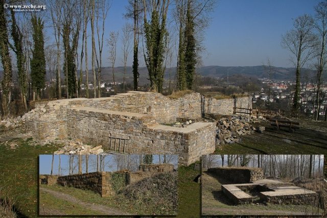
The remains of the Castle can be visited
Rüdenburg Castle

The Rüdenburg, also known as Alte Grafenburg or simply Alte Burg, is a castle ruin near Arnsberg in the Hochsauerlandkreis in North Rhine-Westphalia. The hilltop castle was almost certainly built between 1050 and 1062 by Count Bernhard II of Werl. The name of the old castle serves to distinguish it from the Grafenburg (approx. 2 km as the crow flies) on the later Arnsberg Castle Hill, separated by the Ruhr valley.
According to older excavation reports, a ringfort stood at this location during Saxon and Carolingian times. Recent excavations, however, deny a prehistoric or early historical origin.
The mountain fortress on the Römberg (303 m) served to secure the territories recently acquired by the Counts of Werl in the area of what would later become Arnsberg, and to control the long-distance route leading from the Rhine via Lüdenscheid/Balve to Arnsberg and further to the eastern Hellweg. Even under the rule of Frederick the Quarrelsome (1092–1124), the castle still belonged to the possessions of the Counts of Werl-Arnsberg.
However, Frederick lost the castle to some of his enemies through an ambush. It is uncertain whether this was related to the conflict between Emperor Henry IV and Lothar of Supplinburg, or whether it involved the Archbishop of Cologne. Likewise, the thesis that the castle was subsequently divided between the Counts of Arnsberg and a Cologne vassal from the Rüdenberg family is not fully substantiated. It can only be assumed that the weakening of the Counts of Arnsberg after the extinction of the older line led to the entire complex passing into the possession of the noble lords of Rüdenberg. It is certain, however, that in 1132 a Herimannus de Rüdenberg was in possession of the castle and, like his successors, served both the Archbishopric of Cologne and the Counts of Arnsberg. The good relations with the Arnsberg Counts were expressed in the marriage of Count Gottfried II to Agnes von Rüdenberg, a daughter of Hermann II von Rüdenberg († 1246).
With Konrad II von Rüdenberg († around 1261), the reputation and influence of the Rüdenberg family reached their peak. After Konrad's death, the inheritance was divided among his three sons, forming three lines of the Rüdenberg family, one of which remained in possession of the castle. This marked the beginning of the political and economic decline of this family. The last documented Rüdenberger was Hermann von Rüdenberg in a document from the Archbishop of Cologne from 1390. Already before that (around 1365), the Alte Burg itself, with its associated lands and rights, had been sold to Wedinghausen Abbey. In the 17th century, the remains of the castle were used as a quarry, among other things, for the construction of the Obereimer manor. Numerous demolitions were carried out during this process.
Around 1929, the remains of the castle were uncovered and archaeologically investigated. From 1988, the castle was restored for four years. The castle expert Joachim Zeune was commissioned by the Arnsberg Heimatbund to re-develop the castle and to correct previous reconstruction errors based on archaeological investigations.
Structures+
Before the actual construction of the castle, the uneven mountain plateau was apparently leveled. The castle had an area of 0.42 ha and is surrounded by a wall about 300 m long and 2.10 m thick. This curtain wall is the oldest part of the complex. Inside, the castle is divided into two sections by a transverse wall. The area behind the castle gate with a gate tower is called the outer bailey. There were economic buildings and a building that probably served as a chapel. The division of the complex into two parts by a wall, however, is part of a later construction phase.
Still in the first construction phase was the so-called keep in the west with a base area of 9.5 × 8.3 m. According to older information, it had about five floors and was approximately 25 m high. More recent research interprets the building as a large tower house. Around the same time, the already mentioned chapel with an almost square nave and a recessed rectangular choir was built.
Another tower (7.2x9 m) in the east on the outer wall at the border of the later outer and main bailey seems to have been about 20 m high. It dates from a second construction phase. In a third construction phase, which can be dated to around 1250 to 1350, the aforementioned transverse wall was erected. By this time, the tower in the east had already disappeared and its remains were built over. The wall now cut through the chapel and reduced the usable area of the building.
In the residential area, there is an older palas on the castle wall with Romanesque stylistic features and a newer building in the middle of the main bailey without contact with the castle wall. The main bailey also housed a forge and iron smelter, as well as a cistern.
Today, visible, partially restored remains of the complex are mainly found in the area of the outer bailey. These include the wall between the outer and main bailey and the lower parts of the keep. In the area of the main bailey, the lower parts of the newer residential building are visible. A large part of the castle wall, as well as the older palas and the second large tower, are no longer visible.
Legend of the Leather Bridge+
According to legend, the devil built a "leather bridge" from this castle to Arnsberg Castle to help the lord of the castle and his men escape during a siege, thus thanking him for his hospitality. A similar legend of the Leather Bridge also developed for other closely situated castles.
Take Mobile History with you
You are reading this text for free. Premium adds what matters on the road: descriptions read aloud, sites found through your camera, whole regions taken offline.
- Every description, including the ~17,700 Premium sites
- Audio guide: have descriptions read to you on location
- AR finder: see sites through your camera, with distance and bearing
- Unlimited saved sites
14 days free, then from €2.99 a month. Cancel anytime.
Source: Wikipedia · Licence: CC BY-SA 4.0 · Image: http://www.zeche.org/
This description draws on the facts documented in the linked Wikipedia article; Wikipedia content is licensed under CC BY-SA 4.0. Wording and editing: Mobile History.
Location: 51.3994, 8.0534