CastleMarth

Rusteberg (Old) Castle

Rusteberg (Old) Castle

The remains of the Castle can be visited

The castle ruin Rusteberg, also called Rustenberg, is a dilapidated summit castle on an isolated mountain peak between the municipalities of Marth and Rustenfelde in the district of Eichsfeld in Thuringia.

Rusteberg Castle is located on the conical Rusteberg (397.6 m above sea level), which rises steeply from the Leine valley, about 10 km west of the district town of Heiligenstadt. The shell limestone hilltop is an outlier within the Bunter sandstone landscape of western Eichsfeld. In the Middle Ages, an important military and trade route ran here via Arenshausen and Uder into the Eichsfeld.

The initially only weakly fortified hilltop castle on the Rusteberg was first mentioned in a document in 1123 and was already destroyed again around 1160 by Landgrave Ludwig II of Thuringia.

Under Archbishop Adalbert I, the Mainz territory in Eichsfeld was significantly expanded in the 12th century and secured by the construction of several castles. The outstanding importance of the Rusteberg is subsequently underlined by numerous certifications, which also prove the archbishops' stays, and the establishment of a burgrave's office. Militarily and administratively, the burgrave of Rusteberg was supported by ministerials, who were members of the Knorr family, later Knorring, until 1441, when the family emigrated to Lithuania, and bailiffs; in the 13th century, the houses of Everstein and Wittgenstein provided the burgraves. From the middle of the 14th century, the archbishops transferred numerous administrative tasks to the aspiring Heiligenstadt. The administrative office (bailiff's office) remained in the castle until 1540, led by the last vice-dom Siegfried von Bültzingslöwen. During the Peasants' War, the fortress, which had been expanded into a stronghold, was widely bypassed by the peasant hordes. In the Thirty Years' War, the castle was besieged by Hessian-Kassel troops and finally had to surrender, but returned to Electoral Mainz in the Peace of Westphalia. In 1749–1750, the administrative office built an administration building (Rusteberg Castle) at the foot of the castle hill. In this context, the demolition of the hitherto largely intact castle complex began, its stones serving as building material. The castle chapel served the population as a place of worship until very recently.

Description+

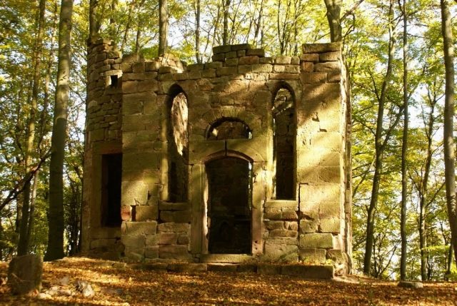
Of the former castle and late medieval fortress, remains of the outer fortifications, partially buried vaulted cellars, and the ruin of the castle chapel are still preserved, which was supplemented in the 19th century using rubble remains with a round tower added to the north and an entrance facade to the west. The former appearance and location of the main buildings are clearly visible on a view published by Matthias Merian. According to this, the castle complex consisted of the core castle at the summit, around which a crescent-shaped, strongly fortified outer bailey was laid. The main access, located to the south of the mountain, was additionally reinforced with a bastion-like outer gate. A ring wall-ditch fortification surrounded the castle complex, which was protected by further walls and towers. After the main buildings were removed, they are now only noticeable as unevenness in the ground. The former keep had a base area of 7.7 by 7.7 meters and a wall thickness of 1.7 meters.

Take Mobile History with you

You are reading this text for free. Premium adds what matters on the road: descriptions read aloud, sites found through your camera, whole regions taken offline.

  • Every description, including the ~17,700 Premium sites
  • Audio guide: have descriptions read to you on location
  • AR finder: see sites through your camera, with distance and bearing
  • Unlimited saved sites

14 days free, then from €2.99 a month. Cancel anytime.

Source: Wikipedia · Licence: CC BY-SA 4.0 · Image: Roland Neubert, Halle (Saale)

This description draws on the facts documented in the linked Wikipedia article; Wikipedia content is licensed under CC BY-SA 4.0. Wording and editing: Mobile History.

Location: 51.3862, 10.0034