CastleBopfingen - Aufhausen

Schenkenstein Castle
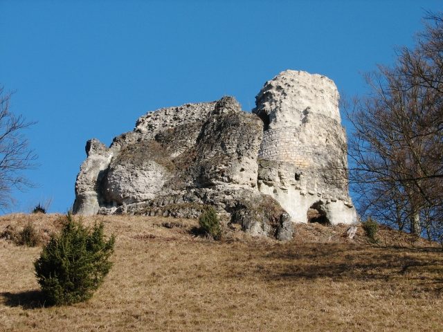
Schenkenstein Castle

The remains of the Castle can be visited

Schenkenstein Castle is the ruin of a high medieval spur castle above the Bopfingen district of Aufhausen in the Ostalbkreis in Baden-Württemberg.

The ruin is located on the so-called Schlossberg at 573 m above sea level. The Schenkenstein is located at the end of a rocky spur of the Schlossberg, about 100 meters long. Approximately 1150 meters southwest, the castle site of Schlössle is also located.

The Schenkenstein was the seat of a noble free family of Stein (de Lapide). A Konrad von Stein appears in various documents from 1138 to 1152. The Steins sold the fortress around 1230 to the Augsburg bishop Hartmann von Dillingen. However, by 1263, the lordship fell back to the sellers and subsequently came into the possession of the Counts of Oettingen.

The Oettingers placed the ministerialis family of the Schenken von Ehringen in the castle. This family subsequently named themselves after the new fief. Georg Schenk von Stein opened the castle to the Imperial City of Nördlingen in 1410 against payment of 200 fl. During the German Peasants' War (1525), the rebels stormed the Schenkenstein, which was subsequently uninhabitable and abandoned. The family of the Schenken von Stein died out in 1902 with Max von Stein in South Tyrol. In 1931, the castle ruin was given as a gift by Prince Eugen von Oettingen-Wallerstein to the municipality of Aufhausen.

Description+

Of the former castle complex, the keep and some wall remains have been preserved. Three section ditches in front of the castle are mostly filled today.

Behind the last ditch, the gate path leads past a rock rib to the former gate. Behind it – slightly elevated – lies the main castle, which is fronted by a terrace or a zwinger to the west. The polygonal core castle (approx. 30 by 38 meters) was enclosed by a ring wall, of which only remnants have been preserved. In the middle rises the round keep, and to the south, the palas was attached to the ring wall. Behind the core castle was the lower castle. The terrain is terraced, and rubble walls and wall remains still bear witness to the former buildings.

The outer wall of the palas is still about 4 meters high and preserved for a length of 7 meters. The adjoining rock block had to be worked horizontally to create space for the residential building. Only remnants of the rising masonry can still be seen at the edge of the rock. The facing of the keep has been partially rebuilt in recent decades. The original wall shell is still present in the north and east, the additions are clearly distinguishable from the old stock. In the upper third of the round tower, the infill masonry is exposed. The tower is still about 16 meters high, the round-arched high entrance is in the southwest. The interior is square (approx. 3 by 3 meters), the diameter is approximately 8 meters.

Below the ruin lies the Jewish cemetery, which was probably established in the 16th century. Today, 363 gravestones are still present. The last burial took place in 1940. Today, the Christian cemetery is attached downstream, and the entire short forest valley serves as a burial site.

Take Mobile History with you

You are reading this text for free. Premium adds what matters on the road: descriptions read aloud, sites found through your camera, whole regions taken offline.

  • Every description, including the ~17,700 Premium sites
  • Audio guide: have descriptions read to you on location
  • AR finder: see sites through your camera, with distance and bearing
  • Unlimited saved sites

14 days free, then from €2.99 a month. Cancel anytime.

Source: Wikipedia · Licence: CC BY-SA 4.0 · Image: Peter Schneider

This description draws on the facts documented in the linked Wikipedia article; Wikipedia content is licensed under CC BY-SA 4.0. Wording and editing: Mobile History.

Location: 48.8558, 10.3190