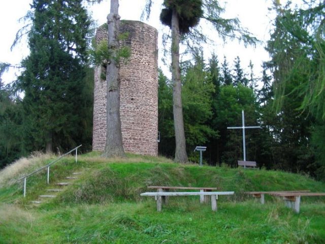
The remains of the Castle can be visited
Schwarzwald Castle

Schwarzwald Castle was a high medieval fortification on a narrow mountain ridge above the Schwarzwald district of Luisenthal in the Gotha district in the Thuringian Forest. It initially served to monitor an important military and trade route that led over the Thuringian Forest near Oberhof and was also used as an administrative center (Amt Schwarzwald) from the 14th century onwards.
The castle site of the spur castle is located in the center of the Schwarzwald district of the municipality of Luisenthal on a mountain spur (519 m above sea level), about 60 meters above the valley floor of the Ohra.
Description+
Schwarzwald Castle is a sectioned castle, protected by steep slopes to the north, west, and south, and still recognizable moats and ramparts. The complex extends over a length of about 250 meters and 20 to 40 meters in width on the crest of the narrow mountain spur, which projects from the Turmberg (659.2 m above sea level) in a westerly direction into the Ohratal. Access was via the hollow way still visible in the east and first led over a neck ditch cut into the rock (this is still clearly recognizable and runs in an arc, it was about 5 meters deep and wide), it was secured by the castle tower existing to the west (current remaining height about 20 meters). On the north side of this neck ditch, there is now an explanatory panel from the local history association; looking towards the village, one can still clearly see the course of a protective wall that made the castle complex inaccessible at this point. Only minor traces of the castle's buildings and fortifications remain. In the middle section of the castle, on the south side, a wall remnant about 1 meter high and still about 10 meters long can be seen along the hiking trail. Further ditches divide the western part of the castle, where the residential and commercial buildings as well as the administration were housed.
An old pass road led through the Luisenthal area towards Oberhof and Meiningen. The first documented mention dates back to 1290, when the castle was named "castrum Swarzenwalt" at the Reichstag in Erfurt. Until 1302, the castle with an associated farm in the valley belonged to the Counts of Kevernburg, was briefly acquired by the Counts of Orlamünde, then by the Counts of Schwarzburg. Around 1367, the city of Erfurt made strong efforts to purchase the castle, wanting to secure one of its most important trade routes to Franconia and save on customs and road tolls. This endeavor failed, and the castle fell to the Thuringian Landgraves. The Wettins established a Vogtship in the castle, thus founding the Amt Schwarzwald, which included the villages of Schwarzwald and Stutzhaus - today Luisenthal, Oberhof, Zella St. Blasi and Mehlis - today Zella-Mehlis, as well as hunting lodges, mines, mills, huts, and forest worker settlements. The Amt was not moved to Zella Sankt Blasii, the main town of the Amt, until 1642. After the Thirty Years' War, the castle ruin was abandoned and served as a quarry for the Schwarzwald settlement, which now expanded around the castle hill. With the construction of the railway line to Luisenthal around 1920, tourism began, making the ruin interesting again and accessible through the creation of walking paths and viewpoints.
Meaning of the Name+
The name Schwarzwald is to be interpreted as an early evidence of the predominant coniferous forest (spruce, fir) in this area in the Late Middle Ages.
Status+
The castle site is a protected archaeological monument. The relevant area is used for tourism and forestry.
Miscellaneous+
In the western part of the castle, a small monument was erected after 1870, commemorating the Franco-Prussian War.
Take Mobile History with you
You are reading this text for free. Premium adds what matters on the road: descriptions read aloud, sites found through your camera, whole regions taken offline.
- Every description, including the ~17,700 Premium sites
- Audio guide: have descriptions read to you on location
- AR finder: see sites through your camera, with distance and bearing
- Unlimited saved sites
14 days free, then from €2.99 a month. Cancel anytime.
Source: Wikipedia · Licence: CC BY-SA 4.0 · Image: http://www.wehrbauten.de/thread.php?threadid=589&sid=9b2b210ff3d27b7a80b9c70dbb4777c0
This description draws on the facts documented in the linked Wikipedia article; Wikipedia content is licensed under CC BY-SA 4.0. Wording and editing: Mobile History.
Location: 50.7686, 10.7315