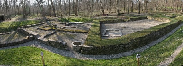
The remains of the Castle can be visited
Stein Castle

Stein Castle, also known as Zullestein, Kellerei Stein, Schlossberg, or Schlossbuckel, was a lowland castle with an associated settlement near the village of Nordheim, Bergstraße district in Hesse. A fortress has been verifiable here since Roman times; the medieval castle was completely destroyed at the end of the 17th century and fell into oblivion. It was not until 1957 that the preserved foundations were rediscovered during oil drilling operations.
Construction of a Fortress in Roman Times+
In the second half of the 3rd century, the Romans diverted the course of the Weschnitz by breaking through the dune hills near Lorsch and creating a canal to the west towards the Rhine. Afterwards, stone blocks weighing up to 30 tons could be transported by damming the Weschnitz from Felsberg in the Odenwald (granite) or from Auerbach (marble) to the Roman castella as far as Trier. The Basilica was built there between 328 and 337. The Romans secured quarrying and transit rights through a treaty with the Alamannic king Macrian.
In the 4th century, a late Roman multi-story fortress (burgus) or watchtower with a base area of 21.3x15 meters and a ship landing stage 42 meters long was built at the new Weschnitz estuary. The time of construction is presumed to be under Emperor Valentinian I (364–375). 100 years after the Romans withdrew from the Limes to the left bank of the Rhine, the ship landing burgus was built on the Germanic opposite bank, which was inhabited by Alamanni, for security. The place was called Zullestein, which is said to be derived from a Celtic river god.
A well-preserved landing burgus from the same period of origin has also been found in Ladenburg (Roman Lopodunum), about 30 kilometers further along the Neckar. A similar small fortress existed on the Schwarzbach near Trebur-Astheim.
The Settlement of Zullestein+
On May 26, 836, King Louis II, the German, gifted his estates in Biblis, Wattenheim, and the village of Zullestein to Count Werner (Werinher). In 846, Count Werner further gifted the three aforementioned places to Lorsch Abbey. Afterwards, it was developed as a port, trading post, and settlement, as later ceramic finds could prove.
In 995, the castle, with its new name Stein, received market rights from Otto III on the recommendation and request of Abbot Salmann of Lorsch Abbey. This transferred the rights of use to the monastery. The place was the seat and administration of the Kellerei (tax collection office).
The New Stein Castle+
In 1068, Stein came into the possession of the Bishops of Worms, who built a new castle. The inhabitants were thereafter obliged to pay tithes to St. Andrew's Collegiate Church. In May 1160, after a prolonged legal dispute between Lorsch Abbey and the Worms citizen Werner, a settlement was reached. Among many other witnesses were the Worms ministeriales Sigfrid and his brother Burkard von Steine. From 1232, a round keep was built, as depicted by Matthäus Merian the Elder before its destruction in the Thirty Years' War.
The Castle Becomes Palatine+
In 1363, Bishop Dietrich pledged half of the Kellerei vom Stein to Count Walram von Sponheim. In 1380, half of the Kellerei belonged to the Electoral Palatinate. In 1385, Ruprecht I of the Palatinate established himself with a condominial share (joint rule) in the Kellerei Stein. On January 8, 1387, the Steiner Pfandschaft (pledge) began, whereby the Kellerei with its three administrative districts Lampertheim, Hofheim, and Nordheim was pledged by half to the Electoral Palatinate.
During his reign from 1450 to 1476, Frederick I, the Victorious, set himself the goal of combating robber knighthood. This was necessary here because flag signals were exchanged between Stein Castle and Ibersheim on the left bank of the Rhine, from a tower at the castle, for communication, so that traders on the Rhine could then be ambushed.
On January 17, 1463, the governor and house commander of the Teutonic Order in Ibersheim sold his meadows on the right bank of the Rhine to ten Nordheim citizens.
In 1504, Landgrave Wilhelm II of Hesse conquered Stein Castle as a result of the Palatine-Bavarian feud, when Emperor Maximilian I imposed the imperial ban on Ruprecht, the son of Palatine Count Phillip the Upright, and commissioned Wilhelm II with the execution of the ban. Consequently, it remained with Hesse until 1517. Since 1507, Thönges Wolff von Todenwarth was the Hessian Keller (steward) at Stein Castle and from 1510 to 1518 the local bailiff. Between 1550 and 1650, the Starkenburg office additionally built a Landgraben (moat) as a Landwehr (defensive barrier) between Stein Castle and Bensheim.
Stein Castle in the Thirty Years' War+
On August 21, 1621, the Spanish conquered Stein Castle under their new commander Gonzalo Fernández de Córdoba, Spinola's successor. They came with 2000 cavalry, 4000 infantry, and four cannons. Faced with this overwhelming force, the garrison of Frederick V, the Winter King, under Colonel Hans Michael Elias von Obentraut, known as "German Michel," had to withdraw. There is a contemporary print of the fortress with the pontoon bridge and the two bridgeheads.
When the Swedes under Gustav II Adolf approached in 1631, the Spanish troops of the Imperial-Catholic League set Stein Castle on fire. Before that, Merian was able to make his drawing and in 1645 published a copper engraving of the Kellerei Stein in his Topographia Palatinatus Rheni.
The End of the Castle+
In 1657, Elector Carl Ludwig of the Palatinate and Archbishop Johann Philipp of Mainz decided to demolish the castle. By 1688 and 1689 at the latest, during the devastation of the Palatinate, the more than 400-year-old prominent round tower also disappeared. Due to stone robbery, parts of the above-ground buildings came to Nordheim and Ibersheim (stonemason's marks M or W).
On August 26, 1705, the Steiner Pfandschaft of January 8, 1387, ended through a treaty between Prince-Bishop Franz Ludwig von Pfalz-Neuburg and Elector Johann Wilhelm, according to which the Prince-Bishopric of Worms received the Kellerei Stein with Lampertheim from the Electoral Palatinate.
In 1785, various Nordheim citizens purchased properties belonging to Stein Castle from the episcopal Worms government. The Steiner estate was then divided into 30 lots or numbers and marked with stones.
Because the Hessian Grand Duke absolutely wanted the land around the former castle, the Nordheim citizens sold 10 Morgen and 195 Klafter for little money.
Rediscovery and Scientific Processing+
On September 25, 1957, the company Gewerkschaft Elwerath, Hanover (later BEB, then Wintershall, and today Exxon Mobil) began its sixth oil drilling in Wattenheim and thereby encountered the foundations of the hitherto lost Stein Castle. The site is located approximately 500 m from the current Rhine bank, south of the Weschnitz estuary. On March 12, 1958, the oil drilling in the Pechelbronn layers (lower Oligocene) ended at a depth of 2,415 m.
On July 8, 1970, excavations for the remains of the castle began by the state archaeologists, Darmstadt branch, under the direction of Dr. Werner Jorns at the "Schlossbuckel." These works continued until 1972 and were financially supported by the operators of the nearby Biblis nuclear power plant, RWE and Hochtief.
The scientific publication was made in 1974 by Friedrich Knöpp, archive director of the Darmstadt State Archives. After 1980, the care of the excavation site was handed over to the municipality of Biblis. In 1989, Dr. Werner Jorns published contributions on "Zullestein" in various writings. In 2001, a dissertation by Sven-Hinrich Siemers on the history of the castle followed. In 2001, the oldest Salbuch, also called Pompernal, of the former Kellerei Stein was discovered in the Worms city archive. In 2005, the municipality of Biblis joined the Bergstraße-Odenwald Geopark, which is responsible for the maintenance of the 30-year-old facility. The Nordheim Local History Association (VfH) demands maintenance measures at the excavation site, as otherwise decay threatens.
Take Mobile History with you
You are reading this text for free. Premium adds what matters on the road: descriptions read aloud, sites found through your camera, whole regions taken offline.
- Every description, including the ~17,700 Premium sites
- Audio guide: have descriptions read to you on location
- AR finder: see sites through your camera, with distance and bearing
- Unlimited saved sites
14 days free, then from €2.99 a month. Cancel anytime.
Source: Wikipedia · Licence: CC BY-SA 4.0 · Image: http://de.wikipedia.org/wiki/Datei:Burg_Stein_01.jpg
This description draws on the facts documented in the linked Wikipedia article; Wikipedia content is licensed under CC BY-SA 4.0. Wording and editing: Mobile History.
Location: 49.7037, 8.3923