CastleAuerbach-Steinamwasser

Steinamwasser Castle
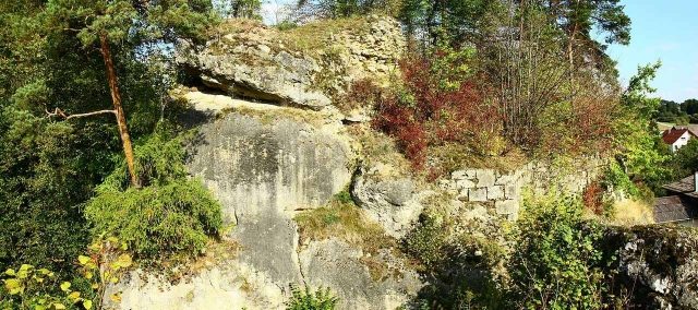
Steinamwasser Castle

The remains of the Castle can be visited

The castle ruin Steinamwasser, or Strebenstein as the castle was later called, is a former high medieval noble castle above the village of Steinamwasser, which is located southeast of the town of Pegnitz in the Upper Palatinate district of Amberg-Sulzbach in Bavaria, Germany.

Since the ruin of the hilltop castle is located on a rock tower that drops vertically on all sides and has no access, it cannot be entered.

The castle ruin is located in the Franconian Switzerland-Veldenstein Forest Nature Park immediately northeast of the village of Steinamwasser, about 6 kilometers

southeast of Pegnitz. The castle stood on the northern bank of the Ortlesbach on a freestanding, approximately 20-meter-high rock mass at the confluence of the Ortlesbach and Goldbrunnenbach.

Near Steinamwasser Castle were other former medieval castles: to the south, Festenberg Castle above Staubershammer and Gernotenstein Castle near the monastery in Michelfeld, to the northwest, Böheimstein Castle, all of which are now only visible as castle sites. Another suspected castle site is located about 725 meters north-northwest of the Steinamwasser ruin.

History of the Castle+

The village of Steinamwasser was already mentioned in a document in 1008, when the later Emperor Henry II donated the village to the Prince-Bishopric of Bamberg. In 1119, parts of the village came to the Michelfeld Monastery, founded on May 6, 1119.

To this day, there is no precise knowledge about the time of origin and the builder of Steinamwasser Castle. It was probably built during the 12th century, because in 1144, a "Syboto von Steinigewasser" appears in a document as a witness to Bishop Egilbert of Bamberg. However, Syboto was not a ministerialis of the Diocese of Bamberg; he was clearly distinguished from the episcopal-Bamberg ministeriales in the witness list of this document by an "also". Among these other witnesses are also a Syboto von Turndorf and his son of the same name and his presumed brother Luitpolt.

The Nuremberg castle researcher Hellmut Kunstmann suspects that Syboto von Steinigewasser, due to the same first name, was a member of the Sulzbach ministerial family von Thurndorf. The last known member of the family is a "Sigboto von Steinenwazzer", also attested as a witness in 1179. At an unknown time, Steinamwasser Castle then came into the possession of the Diocese of Bamberg.

The castle itself is mentioned for the first time on September 11, 1295, when Bishop Arnold von Solms pledged his fortress "Steinigewazzer" to Jutta, the widow of Landgrave Gebhard von Leuchtenberg, who died in 1293, and her son Ulrich.

Jutta was born von Schlüsselberg. The Leuchtenbergers passed the castle on to their vassals, the "Stören von Störenstein"; in 1348, it was still in the possession of Heinrich Stör.

Only at the beginning of the 15th century did the castle return to the Diocese of Bamberg after the pledge, but at that time it was already a ruin. It was probably destroyed during the war between the Bavarian Palatine Counts and King Wenceslaus, when the Vicedom of Amberg, which was then the seat of government of the Palatinate, Johann von Hirschberg, conquered Auerbach, the then capital of New Bohemia, Michelfeld Monastery, and probably also Steinamwasser, which was still in the possession of the Leuchtenbergers at that time, on September 23, 1400. The Leuchtenbergers were on the side of the Bohemian King Wenceslaus, while the Bishop of Bamberg was an ally of the Palatine Counts, which allowed the Bishop to regain possession of the castle after its conquest by Johann without having to redeem it from the Leuchtenbergers' pledge.

In 1405, the Bamberg Prince-Bishop Albrecht von Wertheim granted Hans Streber "daz Burgstal czu Strebenstein in Villa Steingenwasser". After him, the castle was now called Strebenstein, and he had to pledge to serve the bishop with the castle against everyone, except against Duke Johann of Bavaria. Hans was a citizen of the imperial city of Nuremberg; he rebuilt the castle within two years. However, he was subject to restrictions, because on March 13, 1407, Elisabeth Streberin and her son Hans had to pledge "that the house, which Duke Johann in Payern has allowed them to build in Steinygenwasser in the lordship of Aurbach", "that we shall not fortify the same house further with masonry, neither inside nor outside, in any way other than it is now fortified and built, but with woodwork we may well build it and cover it with tiles and wall one tile thick into the walls, as much as is necessary for the house". So they were only allowed to erect a thin-walled half-timbered building. They also had to grant the duke the right of opening against everyone, except against the Bamberg Abbey and the city of Nuremberg.

In 1412, Hans Nankenreuther was enfeoffed with half of Strebenstein Castle, and the second half was granted to Hans Streber zu Strebenstein in 1422.

The second destruction of the castle took place in 1430, when it was burned down during the Hussite Wars, which took place between 1419 and 1439. The reconstruction of the castle by Hans Streber as half-timbered buildings probably facilitated the conquest.

Until 1441, the castle was only granted as a castle site to various owners; from 1446, when half of the castle was granted to Friedrich von Künsberg, there is again talk of a Strebenstein Castle. The renewed reconstruction of the castle therefore falls in the years between 1441 and 1446.

A third and probably final destruction of Strebenstein Castle probably took place between 1459 and 1463 during the Princes' War, because in 1476, the feudal share of the Künsbergers is referred to as a quarter of the Strebenstein castle site.

The last enfeoffment to the von Künsberg took place in 1525; half of the lords of Nankenreuth was granted until July 19, 1624.

Prince-Bishop Franz von Hatzfeld granted half of the castle to Doctor Georg Einwag on October 10, 1636; he was again enfeoffed with half on April 11, 1643. In the following year, his minor son Hans Sebastian was then enfeoffed with the castle through his feudal lord Doctor Heinrich Mertloch.

It is not precisely known whether the castle was rebuilt after the Princes' War and finally destroyed in the Thirty Years' War. The enfeoffments until 1644 do not allow any conclusions, because even destroyed castles were granted if a reconstruction was to be expected.

After the Thirty Years' War, the diocese probably no longer had much interest in its remote property, also because the castle there no longer had much military value.

Today, the site of the former castle is overgrown with trees; only a few wall remains have been preserved. Since the castle was located on a rock tower, it is now very difficult to climb.

Description of the Castle Ruin+

The former hilltop castle stands on the edge of a valley, whose northern side here partially drops vertically, on an approximately 20-meter-high, 30-meter-long, and 10-meter-wide rock tower. This rock tower is separated from the plateau by an approximately 5 to 15-meter-deep and four-meter-wide natural gorge. The rock, which drops vertically on all sides, was surrounded by a curtain wall, of which only larger remains are still preserved in the south and east. The wall consists of smoothly worked and carefully laid ashlar stones. The plateau has an elongated oval shape and extends from east to west. On the east side of the plateau was the former access, opposite, on the west side, which was slightly elevated by about 2 meters, there was probably a tower or tower-like building.

The ascent to the castle, of whose building fabric not much remains, went from the valley of the Ortlesbach through the gorge in a westerly direction along the north side of the rock to the plateau, then turned in a hairpin bend to the east and then reached an approximately two-meter-high, freestanding rock mass, which drops into the gorge on its south side. In front of this rock mass is a slight depression, which was probably bridged by a wooden construction. Access to the castle was then from this rock via a drawbridge, which spanned the three-meter-wide gorge here.

Take Mobile History with you

You are reading this text for free. Premium adds what matters on the road: descriptions read aloud, sites found through your camera, whole regions taken offline.

  • Every description, including the ~17,700 Premium sites
  • Audio guide: have descriptions read to you on location
  • AR finder: see sites through your camera, with distance and bearing
  • Unlimited saved sites

14 days free, then from €2.99 a month. Cancel anytime.

Source: Wikipedia · Licence: CC BY-SA 4.0 · Image: http://de.wikipedia.org/wiki/Datei:Burgruine-Steinamwasser7.jpg

This description draws on the facts documented in the linked Wikipedia article; Wikipedia content is licensed under CC BY-SA 4.0. Wording and editing: Mobile History.

Location: 49.7276, 11.6060