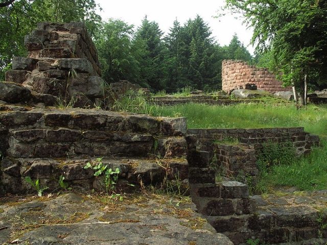
The remains of the Castle can be visited
Steinenschloss Castle

The castle ruin Steinenschloss, also known as Atzenstein, Biebermühler Schloss, or Steiner Schloss, is located in the municipality of Thaleischweiler-Fröschen in the Southwest Palatinate, above the confluence of the Schwarzbach and Rodalb rivers.
From the hilltop castle, situated approximately 295 meters above sea level and 48 meters above the valley floor, the adjacent valleys were clearly visible. Due to this strategically favorable location, the castle may have served as a southern border fortress.
Name+
The original name of the hilltop castle, built around the year 1100, can no longer be historically proven. In the 13th century, a settlement named Steinen, Steigen, or Stegen existed below the castle hill. In 1564, simultaneously with the mention of this settlement as a wasteland, the name "Steiner-Schloss" appeared in a document, from which the name "Steinenschloss" developed. The castle might possibly have been called "Atzenstein," as there was a farm of the same name in the vicinity. However, name researchers reject this thesis.
Description+
The castle complex has roughly the shape of an iron, with its tip pointing south; its length is 70 meters, and its width is about 46 meters. The enclosing wall, 1.80 to 2.50 meters wide, consists of hewn sandstone ashlar, partly supplemented by bossed ashlar. The upper bailey, located on a sandstone rock, is separated from the lower bailey by a rock ledge, where the cistern is also located.
A fore-bailey was located west of the castle complex outside the ring wall. It extended along the entire western side of the moat, and even further south by a few meters.
In the lower bailey, in addition to utility buildings and rooms presumably used as guard chambers, was also the castle entrance. It consisted of a 2.50 meter wide and 3.15 meter high gate, secured by a drawbridge and a moat.
The upper bailey is accessible through a passage carved into the rock. It housed the residential buildings, i.e., the palas, kitchen, latrine facilities, the armory, and a mighty round tower that dominates the entire castle complex. With an inner diameter of 8.50 meters and its 2.50 meter thick walls, it reaches an outer diameter of 13.5 meters. This tower probably served as a keep, but due to its large diameter, it could also have been a residential tower. To the north, the upper bailey is protected by a kinked shield wall, which was probably damaged in the 12th century. Its western half was rebuilt during the second half of that century, whereas the eastern part of the wall dates from the 11th century.
The exact founding date of the castle is unknown. Excavation finds indicate signs of settlement as early as the Younger Stone Age and the Hallstatt period.
According to the dating of the masonry of the existing wall remains, the castle was founded around the year 1100. The builders were probably the Counts of Leiningen. A Roman villa about one kilometer away possibly served as a source of building material for the late Salian castle complex.
The massive round tower was built approximately between 1125 and 1166, thus later than the castle. With its Salian-Staufer architectural elements, it is one of the largest of its time in the Rhineland-Palatinate region. Just a few years later, a fire destroyed the castle; it could be one of the three Saarbrücken castles that Emperor Frederick Barbarossa had razed in 1168, in addition to Saarbrücken Castle. In a document from 1237, the castle is considered already destroyed and was not rebuilt.
From the 13th to the 18th century, the castle ruin changed hands several times. Listed are the Counts of Leiningen-Dagsburg, Zweibrücken-Bitsch, Leiningen-Hardenburg, from 1564 described as a wasteland belonging to the Counts of Leiningen-Hardenburg-Dagsberg, and from 1570 Hanau-Lichtenberg.
In the 19th century, the ruin was used as a quarry and completely destroyed. The removed stones were used for house building in the surrounding communities and in 1875 for the construction of Pirmasens-Nord (Biebermühle) train station and the railway line. The ruin is currently state-owned and managed by the State Office for Monument Preservation, Mainz.
Excavations, Reconstruction, and Finds+
In 1896/97, Prof. Dr. Mehlis carried out initial excavations, but had to stop the work due to lack of funds.
Under the supervision of the Office for Pre- and Early History, Speyer, unearthing work was carried out after the Second World War in 1956/57 by Dr. L.A. Hoffmann, a physician. This awakened public interest in the castle, which at that time was merely a rubble heap overgrown with trees and forest plants.
In the spring of 1968, excavation work began, and in 1973, the "Burgverein Steinenschloss" (Castle Association Steinenschloss) was founded for this purpose. Today, the local history association of Thaleischweiler-Fröschen supervises the excavations and work on the complex. Meanwhile, the enclosing wall and the palas area, including the latrine facilities, have been renovated, the gate system of the lower bailey reconstructed, and the wall lines of some utility buildings made visible again. The tower, uncovered from 1985 onwards, has been rebuilt from 1989/90 to a height of 10 meters using stone blocks up to 1m long and 55 cm high.
The artifacts recovered from the construction and fire debris of the ruin range from ceramic discs and gaming pieces made of sandstone or deer antler to iron tools and weapon parts, as well as door handles and keys. Gilded bronze ornamental fittings also came to light; in addition, a double-headed eagle made of gilded bronze, probably also an ornamental fitting. Furthermore, a stone workpiece with a round-arched slit window was recovered. During the unearthing of the western outer area, a shell-like emblem was discovered.
Thanks to the extensive restoration and unearthing work already carried out, one can get an idea of the appearance of the former castle.
Take Mobile History with you
You are reading this text for free. Premium adds what matters on the road: descriptions read aloud, sites found through your camera, whole regions taken offline.
- Every description, including the ~17,700 Premium sites
- Audio guide: have descriptions read to you on location
- AR finder: see sites through your camera, with distance and bearing
- Unlimited saved sites
14 days free, then from €2.99 a month. Cancel anytime.
Source: Wikipedia · Licence: CC BY-SA 4.0 · Image: http://de.wikipedia.org/wiki/Datei:Steinenschloss_mauer.jpg
This description draws on the facts documented in the linked Wikipedia article; Wikipedia content is licensed under CC BY-SA 4.0. Wording and editing: Mobile History.
Location: 49.2656, 7.6054