CastleAngermünde-Stolpe

Stolpe Castle

Stolpe Castle

The remains of the Castle can be visited

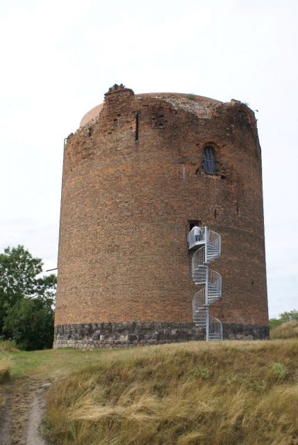
Stolpe Castle is located on a hill above Stolpe, a district of the town of Angermünde since 2003, approximately 15 kilometers southeast of the town center in the Uckermark district of Brandenburg. The preserved tower, with an outer diameter of 18 m, is probably the strongest keep in Germany. Although the tower is referred to as a keep (Bergfried), it is actually a donjon, as it was inhabited. Based on a legend, the tower is popularly known as "Grützpott" (Groat Pot).

Construction Description+

Of the medieval complex, only the residential tower/keep ("Grützpott") remains today, in addition to the ramparts. With a diameter of 18 meters, it is the largest keep in Brandenburg.

The Stolpe Tower was built as a Romanesque castle tower in brick construction. It was the highest part of a fortified castle complex with a ring wall and gatehouse. The lower part consists of glacial erratics and three layers of sandstone (four layers inside). This stone, referred to as "Höör sandstone," is not a glacial erratic. It originates from present-day southern Sweden, which was then under Danish rule. It demonstrates Danish influence extending into this area.

The tower was built as a defensible residential building. Probably only the area from about 10 m height was used as a living area (79 m²) with a ceiling height of about 4 m. The floor above served as a defensive platform. It was covered by a battlement, allowing defenders to command the entire castle complex with weapons and projectiles from this height.

Danes are assumed to be the master builders because the area around Stolpe belonged to the Duchy of Pomerania, which was under Danish suzerainty. Furthermore, no comparable structure of this quality is known from the neighboring Margraviate of Brandenburg in the 12th century. The brickwork is extremely homogeneous, laid in stretcher and header courses; the precisely manufactured bricks are striking, a craftsmanship that the Cistercian monks of this region did not master centuries later when building Chorin Abbey. The interior of the tower is octagonal.

The height of the tower with its concealed foundation is approximately 25 m. The foundations of the keep extend about 10 m into the ground. In the lower part of the tower, the wall thickness is over 6 m. At the time of its construction, the tower had only a single entrance at about 10 m height. This entrance has a Romanesque arch as its finish. The "ground floor" was once about 15 m high and had a band-rib vault as its upper closure. It served as a dungeon and/or storage room. The roof was conical or pyramidal, located within the battlements, and covered with tiles (monk and nun).

Originally, a Slavic rampart from the 7th/8th century was located here. Eight graves, including two significant Slavic princely graves, from the first half of the 12th century were discovered through the observation of a badger's sett and archaeologically investigated in autumn 2012. They bear witness, among other things, to military conflicts during this period. Between 1170 and 1190, the Dukes of Pomerania had a strongly fortified residential tower, the Stolpe Tower, which is still preserved today, built within the rampart.

Around 1250, the southern Uckermark came into the possession of the Ascanians. The castle became the seat of the Vogt of the Margraves of Brandenburg. The settlement that developed around the castle was granted town rights in 1286 by Margraves Otto IV and Konrad I. However, the town was not fortified. In 1301, the Vogtland was pledged to the Archbishopric of Magdeburg, but in 1324, by an arbitration award from King Christopher II of Denmark, it returned to Brandenburg.

In 1355, Margrave Louis II ceded the castle to Pomerania. It remained with Pomerania until 1446. The Dukes of Pomerania enfeoffed various noble families with the castle. In the war against Pomerania for the Uckermark, Elector Frederick II "Iron Tooth" of Brandenburg conquered Stolpe Castle in 1445. During this, the upper part of the castle burned down, and the ruins formed a meter-thick layer of rubble that protected the substance of the tower for well over 500 years. The castle had been a ruin since 1445 and was not rebuilt.

In January 1446, the owner of the castle, Hans von Buch, confirmed that Elector Frederick II had conquered the complex. The Elector left the castle to Hans von Buch as a Brandenburg fief. With the construction of a palace in the village in 1553, the complex lost its importance and fell into disrepair over time.

During the lifetime of the geologist Leopold von Buch (1774–1853), a friend of Alexander von Humboldt, who was born in Stolpe, around 1840 (other sources mention 1844), another underground access was created through a tunnel from approximately the north. This tunnel is attributed to von Buch's initiative, which is not substantiated.

The palace was severely damaged by fire in 1917 and only restored in 1921/1922 with significant alterations. Towards the end of World War II, on April 26, 1945, the tower received three direct hits from Soviet artillery fire. The firing then ceased because little damage to the tower was observed. The impacts are clearly visible near the first entrance and in the sandstone foundation.

Until the fall of the Berlin Wall in 1990, the tower remained largely untouched. In the turmoil of the first post-reunification years, an investor from the old federal states began to clear the tower of rubble with ABM (Arbeitsbeschaffungsmaßnahmen - job creation measures) workers, without regard for archaeological finds. The removal of the rubble from the upper part of the tower led to very rapid weathering. Meanwhile, monument conservators had become aware; the investor had absconded with the funding, and the tower could be preserved.

As an emergency measure, the tower received a kind of "internal ring anchor" made of reinforced concrete and a new covering to save the building fabric.

In 2006 and 2007, the tower castle was renovated and made accessible for tourism; since Easter 2008, the castle has been open to the public again.

Legends+

It was repeatedly reported that there was a secret emergency exit from the tower. A short passage, a few meters long, towards the northwest has not yet been investigated in detail; allegedly, one can stand after a few meters. However, this passage could also be due to the fact that when a larger boulder was encountered during construction, there was no way to remove it. Therefore, the currently existing passage may have been driven a few meters further.

The Grützpott Legend+

Many centuries ago, so the legend goes, the robber knight Tiloff lived in the castle. He particularly targeted merchants who traveled through his territory. One day, he spied on a merchant from Silesia who carried a full money pouch. As the merchant rode through the Stolpe forest, the knight attacked him with a drawn sword. But the merchant already had a pistol, loaded with a silver button from his wife's dress. The button pierced the knight's heart, and he fell dead from his horse. His squires fled in horror to the castle.

Soon, news of the hated Tiloff's death spread to the surrounding villages, and the peasants gathered to destroy the hated castle. They soon captured the castle, but the keep remained. The defenders threw everything imaginable from above at the attackers. When they had nothing left to throw, they threw their finished lunch, a thick groat porridge, at the besiegers. This porridge fell directly onto the helmet of the Stolpe blacksmith, who stood on the top rung of the ladder. With the words "We'll soon scour out the groat pot," he smashed the plank door to the tower with an iron bar. That was the end of the robber's nest. The walls were razed, but the thick tower, the Grützpott, was left standing as a reminder.

Take Mobile History with you

You are reading this text for free. Premium adds what matters on the road: descriptions read aloud, sites found through your camera, whole regions taken offline.

  • Every description, including the ~17,700 Premium sites
  • Audio guide: have descriptions read to you on location
  • AR finder: see sites through your camera, with distance and bearing
  • Unlimited saved sites

14 days free, then from €2.99 a month. Cancel anytime.

Source: Wikipedia · Licence: CC BY-SA 4.0 · Image: Roland Neubert, Halle (Saale)

This description draws on the facts documented in the linked Wikipedia article; Wikipedia content is licensed under CC BY-SA 4.0. Wording and editing: Mobile History.

Location: 52.9806, 14.1159