CastleSimmelsdorf-Strahlenfels

Strahlenfels Castle
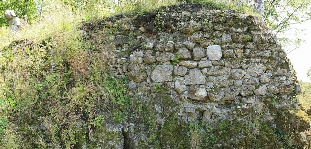
Strahlenfels Castle

The remains of the castle can be visited

The high medieval to early modern castle site of Strahlenfels is the remnant of a vanished spur castle at 570 m above sea level, which once stood on a rock ridge on the edge of the village of Strahlenfels. Today, the castle site is located in the northern municipal area of Simmelsdorf in the Middle Franconian district of Nürnberger Land in Bavaria, Germany. Strahlenfels Castle has completely disappeared; only very few wall remnants bear witness to it, and the castle rock serves as a climbing rock and viewpoint.

The site of the former castle is located in the southern part of Franconian Switzerland, a part of the Franconian Jura low mountain range, on a rock spur projecting westward from the 587 m high Schlossberg. The castle site lies on a rocky elevation about 15 meters above the village, immediately east of the village area of Strahlenfels (Figure 1), which is about 6.5 kilometers north-northeast of the core town of Simmelsdorf.

Nearby are other former medieval castles; to the northwest, within sight, lies the castle ruin of Wildenfels, and a little further west lies Hiltpoltstein Castle. To the southwest is the castle site of Spitzenberg on the 582 m high mountain of the same name, and in the village of Großengsee is the Großengsee Castle, which, however, dates back to a medieval castle. To the southeast are the castle site of Spies and the castle ruin of Riegelstein. Further former castles are located on the Hühnerstein, about 1.4 kilometers east-northeast, and near Stierberg, the ruin of Stierberg.

The name of the castle first appeared in a document in 1254, in which "Heinricus de Stralenvels" was mentioned as a witness. The castle had probably been built shortly before. The ministeriales of Strahlenfels stood in the way of the ministeriales of Wildenstein, who were rising to power in the late 13th century. They built their Wildenfels Castle within sight of the Strahlenfels castle. Soon after, around 1310, the Strahlenfels apparently moved to the moated castle of Reichenschwand, which they had newly built in the village of the same name, and ceded Strahlenfels Castle to the Wildensteins in the first quarter of the 14th century. In 1330, Heinrich V von Wildenstein resided at Strahlenfels Castle; in 1354, he enfeoffed the castle to King Charles IV as a Bohemian fief. Shortly thereafter, in 1360, Heinrich sold the castle to Charles IV, who had by then become emperor, and in 1366/68, the castle was a Bohemian administrative seat.

In the war between the Palatine King Ruprecht and the Bohemian King Wenzel, the castle was apparently conquered by Ruprecht in 1400, because in 1401 Albrecht von Egloffstein received the castle as a pledge. However, it was to remain an "Offenhaus" (open house) of the Palatinate, meaning it had to be accessible at all times for the owner King Ruprecht's troops during wartime.

After the division of inheritance among the sons of the Palatine King, the office of Strahlenfels went to Count Palatine Johann von Neumarkt, who pledged it to the knight Hermann von Freudenberg. The pledge was redeemed a few years later, as Count Palatine Johann sold Strahlenfels to the Wildensteins in 1426. The new owner was probably Martin von Wildenstein, who died in 1466. The Wildensteins had the castle administered by a Vogt (bailiff).

During a Nuremberg attack in the First Margrave War on March 9, 1450, the outer bailey, presumably located at the southern base of the rock, was conquered.

Apparently, the Wildensteins lost interest in Strahlenfels Castle after the Landshut War of Succession, as no maintenance was carried out in the 16th century. Major structural damage is reported from 1547, and by 1589, the castle was barely habitable. Soon after, it was abandoned, as the knight's estate was not very profitable, especially since the Vogt had to be paid.

After the Battle of White Mountain in 1620, in which the Upper Palatinate was occupied by Bavaria, the Wildensteins were dispossessed by the Bavarian Elector Maximilian I; he granted the Catholic Eytel Hanns Truchsess von Höfingen the knight's estate of Strahlenfels. After his death in 1637, a dispute arose over the inheritance. The knight's estate was returned in 1655 to the Wildenstein brothers Hans Christoph and Friedrich Oktavian von Wildenstein, who had by then converted to Catholicism.

In 1759, Ernst Ludwig von Wildenstein sold the knight's estate to Johann Friedrich Wilhelm Buirette von Oehlefeld. Johann was a successful merchant and also bought other knight's estates. In 1771, the Buirettes were elevated to the rank of baron and passed the castle down within their family. However, not much of the castle remained; it was apparently already used as a quarry in the early 17th century. By 1829, only a few remnants were visible.

Today, the site of the former castle is overgrown with forest, and only a few wall remnants remain. The freely accessible castle site serves as a viewpoint, and the north side of the "Strahlenfels" is used as a climbing rock after the clearing of trees and bushes. The castle site can be reached from the village of Strahlenfels by ascending the castle rock from the south.

Description of the Castle Site+

On the west side of the Strahlenfels Schlossberg, a rock spur branches off approximately 100 meters to the west, which was used for the construction of a castle. The north side of the rock spur drops vertically about 15 meters, and the west and south sides also drop steeply, partly interspersed with rocks, also 15 meters. Only the east side is connected to the slightly elevated Schlossberg and had to be protected accordingly. A presumably natural ditch can be discovered there, which perhaps served as a neck ditch.

Of the castle on the rock spur, only a six-meter-long and two-meter-high wall remnant (Figure 4), which is in danger of collapsing, and two smaller wall remnants on the east side, which are only visible from below, remain. In addition, a round cistern with a diameter of about half a meter is present on the castle plateau. It is still approximately half a meter deep and filled with leaves.

In 1589, a residential building still existed, opposite which was a masonry floor, also a building, containing a cellar, a chapel, and above it a grain storage.

The ascent to the castle was on the south side of the rock spur (Figure 2) via a seven-step staircase carved into the rock (Figure 3), from which a narrow path led upwards. Presumably, the ascent can be imagined like that of Pottenstein Castle. Wildenfels Castle and Wolfsberg Castle also had similar ascents.

Possibly, an outer bailey, of which nothing remains, was located on a terrain step 15 meters lower to the south.

At the foot of the rock spur, on the northwest side outside the castle complex, lies a small cave, the Strahlenfels Castle Cave (Cave Cadastre Franconian Alb, D 516), which was enclosed with walls to the outside. It probably served as a storage room for the castle inhabitants.

Take Mobile History with you

You are reading this text for free. Premium adds what matters on the road: descriptions read aloud, sites found through your camera, whole regions taken offline.

  • Every description, including the ~17,700 Premium sites
  • Audio guide: have descriptions read to you on location
  • AR finder: see sites through your camera, with distance and bearing
  • Unlimited saved sites

14 days free, then from €2.99 a month. Cancel anytime.

Source: Wikipedia · Licence: CC BY-SA 4.0 · Image: http://de.wikipedia.org/wiki/Datei:Burgstall-Strahlenfels2,Mauerrest1.jpg

This description draws on the facts documented in the linked Wikipedia article; Wikipedia content is licensed under CC BY-SA 4.0. Wording and editing: Mobile History.

Location: 49.6532, 11.3771