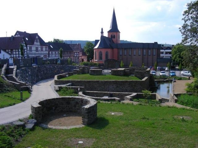
The remains of the Castle can be visited
Lower Castle Rheinbreitbach

The Lower Castle in Rheinbreitbach, a local municipality in the Neuwied district of Rhineland-Palatinate, dates back at least to the second half of the 14th century. The moated castle was the ancestral seat of the Lords of Breitbach; only the foundations of its main building remain.
The grounds of the Lower Castle, so named to distinguish it from the Upper Castle located further south, are situated at 80 m above sea level in the center of Rheinbreitbach and adjoin directly to the east of the parish church of St. Maria Magdalena. To the south, the grounds are bordered by Westerwaldstraße (Rheinbreitbach–Breite Heide), and to the north by the Breitbach stream.
The noble family of the Lords of Breitbach has been documented since the mid-13th century. In 1364, they held a farm in the Mühlental (the former name for the Breitbach valley) as a fief of the Electorate of Cologne. This included a house, which is considered a predecessor to the later castle. In 1473, the Lords of Breitbach moved their seat to Bürresheim Castle near Mayen, but retained the castle and their property in Rheinbreitbach. Extensive repairs were carried out on the building in 1613, and again in 1661 after its destruction by Swedish troops. Further construction measures are mentioned for the years 1707/08, 1726, and finally 1764, when outbuildings were demolished. In 1797, the male line of the noble family ended, and the Lower Castle was inherited by the grandson of the sister of the last male representative, Count Clemens Wenzeslaus von Renesse.
The castle remained in the possession of the Renesse family, but at the latest after the Second World War, it increasingly fell into disrepair and became overgrown, finally being demolished to remnants in the late 1960s. In the 1970s, most of the former enclosing wall also had to make way for the expansion of Westerwaldstraße. From late 2006 to spring 2009, the foundations of the castle were uncovered and restored as a dry stone wall as part of a park-like redesign of the surrounding area under the name Renesseplatz, to preserve them permanently as an archaeological monument and make them publicly accessible.
Layout+
The origin and core of the Lower Castle was a four- to five-story residential tower on a square plan with a pyramidal slate roof. The window arrangement was irregular. A five-meter-wide and three to four-meter-deep moat (as of 1940) surrounded the building. A three-story annex on the west side with a barrel vault on the ground floor is dated to the Late Gothic period. In the 17th century, a four-story southern wing including a staircase was built, whose ground floor had a groin vault and probably served as a chapel. The upper half of this wing, as well as an economically used annex on the north side and a two-story superstructure of the Late Gothic western tract, were half-timbered constructions. The entrance to the castle dated from the end of the 17th century, when it had been renewed. South of the castle building were cellars and stables, and to the north, directly on the Breitbach, a long half-timbered building from the 18th century, a former farm building of the Lower Castle, has been preserved.
After the renovation of the castle ruins completed in 2008/2009, the exposed and restored foundations of the main building have a height of about one meter. On the east and south sides of the ruin, part of the original moat is also water-bearing again. To the west, the area is delimited by the preserved part of the former enclosing wall with its round-arched gate entrance directly opposite the church.
The round-arched gate of the Lower Castle and the former 18th-century farm building are protected as cultural monuments, and the foundations as an archaeological monument. The Lower Castle is considered one of the oldest moated castles in the Rhineland.
Take Mobile History with you
You are reading this text for free. Premium adds what matters on the road: descriptions read aloud, sites found through your camera, whole regions taken offline.
- Every description, including the ~17,700 Premium sites
- Audio guide: have descriptions read to you on location
- AR finder: see sites through your camera, with distance and bearing
- Unlimited saved sites
14 days free, then from €2.99 a month. Cancel anytime.
Source: Wikipedia · Licence: CC BY-SA 4.0 · Image: http://www.wehrbauten.de/thread.php?threadid=990&hilight=Rheinbreitbach
This description draws on the facts documented in the linked Wikipedia article; Wikipedia content is licensed under CC BY-SA 4.0. Wording and editing: Mobile History.
Location: 50.6171, 7.2308