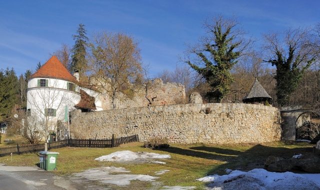
The remains of the Castle can be visited
Unterthal Castle

The castle ruin Unterthal is located in the market town of Thal in Styria. Its history dates back to the 13th century. After several expansion phases, it was abandoned at the beginning of the 17th century and began to decay.
The ruin is located in the municipality of Thal in the hamlet of Linak. It stands on a ridge that extends from north to south between the Kirchberg and Lake Thalersee. This ridge slopes steeply to the north and east and less steeply to the south and west.
The castle was probably built in the 13th century by the Lords of Thal. During the noble uprising against Duke Albrecht I in 1292, the castle was destroyed. In the 14th century, the destroyed castle came into the possession of the Windisch-Graetz family, who had it rebuilt. At the latest by 1322, the castle had a chapel, which served as a parish church until the 18th century. It was demolished in 1772. In the 15th and 16th centuries, the castle was expanded into a residential palace. In 1569, Sebastian von Windisch-Graetz sold it to Georg von Khevenhüller, who immediately passed it on to Archduke Karl III. The latter leased the property. In the 17th century, the castle was again adapted to the advancing developments in weapon technology with bastions and behind them, firing chambers and gun emplacements. In 1623, Hans Ulrich von Eggenberg became the owner of the castle, which was connected to the Eggenberg dominion. The Eggenbergers allowed the complex to fall into disrepair, and a fire in 1715 destroyed a large part of the still habitable rooms. Between 1774 and 1943, the Counts of Herberstein owned the ruin. However, they allowed it to continue to decay. Since then, it has been in private ownership. In 1996, a 17th-century round tower was converted into a summer apartment.
Description+
In the center of the extensive complex are the remains of the rectangular, formerly probably three-story tower house, which belongs to the oldest preserved parts of the castle. It was probably built in the early 14th century. This is suggested by the layered, regular rubble masonry with corner stone settings of the up to 1.5 meter thick walls. The southern wall of the tower house probably dates from a later renovation. The cellar of the building, like the ground floor, has a stone barrel vault. On the ground floor, it is only partially preserved. Originally, the tower was entered via an entrance on the east side on the first floor. The gate in the western part of the ground floor dates from the 16th century. The corbels above the gate, which indicate a former oriel, were added later.
Adjoining the northern wall of the tower house is a curtain wall that follows the terrain. The keyhole embrasures in the upper part of the wall, which are now poorly preserved, date from around 1500. This wall formerly had a battlement, of which the wall offsets are still preserved today. In the middle of the area enclosed by this curtain wall, one finds the masonry remains of several buildings. Directly south of the tower is a pile of rubble. Furthermore, in the south, there are also remains of a curtain wall, which was subsequently reinforced by round and semi-circular towers. A recently built round tower completes the complex. The former gate system in the southeast of the castle has almost completely disappeared today.
In the northern and western part of the castle, an advanced bastion was built in the 17th century. This has an inclined plinth on which the wall stands. Between the wall and the plinth is a dressed stone torus. In the east, further remains of this expansion phase can be found.
Especially in the southern and southwestern part of the castle complex, conservation attempts were made, which, however, significantly altered the original substance.
Take Mobile History with you
You are reading this text for free. Premium adds what matters on the road: descriptions read aloud, sites found through your camera, whole regions taken offline.
- Every description, including the ~17,700 Premium sites
- Audio guide: have descriptions read to you on location
- AR finder: see sites through your camera, with distance and bearing
- Unlimited saved sites
14 days free, then from €2.99 a month. Cancel anytime.
Source: Wikipedia · Licence: CC BY-SA 4.0 · Image: http://commons.wikimedia.org/wiki/File:Thal_-_Ruine_Unterthal.jpg
This description draws on the facts documented in the linked Wikipedia article; Wikipedia content is licensed under CC BY-SA 4.0. Wording and editing: Mobile History.
Location: 47.0728, 15.3633