CastleOberneukirchen-Waxenberg

Waxenberg Castle
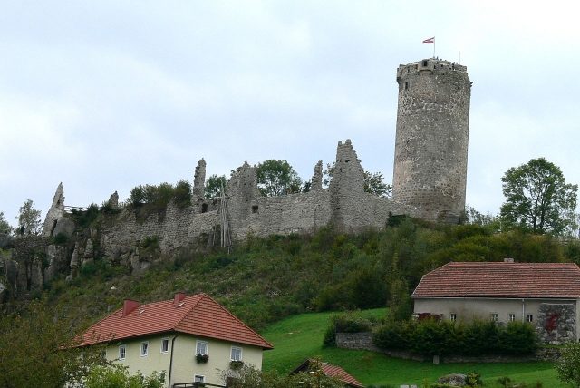
Waxenberg Castle

To be privately owned

The Waxenberg castle ruin is located above the village center of Waxenberg in the municipality of Oberneukirchen in the Mühlviertel region of Upper Austria. The current ruin was built before 1300 and burned down in 1756 after a lightning strike. The ruin is owned by the Starhemberg family and has been renovated by the Waxenberg Cultural Association since the 1950s.

Name+

The compound name is most likely derived from Middle High German "was" or "wahs" (=sharp, cutting), which describes the terrain of the castle site: In this sense, the name Waxenberg describes a pointed/steep mountain cone.

Documented names were: 1146: Wessenberg 1216: Wassenberch 1359: Waezsenberg 1416: Wächsenberch 1426: Wässenwerkch 1499: Wechsenburg 1544: Wächsenburg 1569: Wäxennberg

A first Waxenberg Castle was built in 1140 by the Lords Ulrich and Cholo von Wilhering. It is located about 4.5 kilometers south in the municipality of Herzogsdorf and is now known as Rotenfels or Alt-Waxenberg. The current ruin in the Waxenberg village area was built shortly before 1300, after Rotenfels was abandoned around 1291. The castle belonged to the Habsburgs and was a princely fief. As early as 1306, the Waxenberg regional court was elevated to a county. The regional court was one of the most important and oldest in the central Mühlviertel.

Heinrich von Wallsee appears as the first holder of the fief around 1300. In 1435, the brothers Kaspar and Balthasar Schallenberg acquired the castle, and in 1463, Heinrich von Liechtenstein was mentioned as the owner. After the Liechtensteins, Michael von Traun followed in 1492, Wolfgang Jörger zu Tollet in 1504, and Nikolaus Rabenhaupt von Suche in 1523. The next pledge went to Erasmus and Wilhelm von Gera in 1533. Around 1594, Waxenberg was a refuge during the Turkish threat and well-equipped. In 1614, Christoph von Gera acquired the lordship as a free property for 330,000 guilders. In the Upper Austrian Peasant War of 1626, the castle was captured, plundered, and severely damaged by peasants. As punishment after their defeat, the peasants had to renovate the castle.

In 1644, Konrad Balthasar von Starhemberg bought the castle and lordship, and the castle has been in the family's possession ever since. Around 1750, the lordship included 745 subjects. In 1756, the castle was almost completely destroyed by a lightning strike, then left to decay and thus became a ruin. The Starhembergs moved in 1756 to Waxenberg Castle, located about 200 meters away, which was probably built in the 17th century. In the following period, the castle visibly decayed, and only since the 1950s has the Waxenberg Cultural Association taken care of its preservation and renovated the castle. In that year, the 30-meter-high tower was converted into an observation tower. After various renovation works, these were completed in 2013.

Construction+

The main castle had an area of 885 square meters, the outer bailey covered 1260 square meters. Essentially, only the 30-meter-high, round keep remains of the complex and can be climbed. The keep dates from the 15th century and has a diameter of ten meters with a wall thickness of three meters. The lightning strike of 1756 spared the tower, but the outer bailey has almost completely disappeared. Only remnants of the palace walls can be seen.

Towards the castle, there is still a battery tower from the 16th century. It had wide windows for defense and was located below the outer bailey. The square tower is now open at the top and was formerly covered by a tent roof.

Take Mobile History with you

You are reading this text for free. Premium adds what matters on the road: descriptions read aloud, sites found through your camera, whole regions taken offline.

  • Every description, including the ~17,700 Premium sites
  • Audio guide: have descriptions read to you on location
  • AR finder: see sites through your camera, with distance and bearing
  • Unlimited saved sites

14 days free, then from €2.99 a month. Cancel anytime.

Source: Wikipedia · Licence: CC BY-SA 4.0 · Image: http://commons.wikimedia.org/wiki/File:Waxenberg_-_Blick_auf_die_Burg_vom_Ort.jpg

This description draws on the facts documented in the linked Wikipedia article; Wikipedia content is licensed under CC BY-SA 4.0. Wording and editing: Mobile History.

Location: 48.4756, 14.1886