To be privately owned
CastleChamptoceaux
Château de Champtoceaux
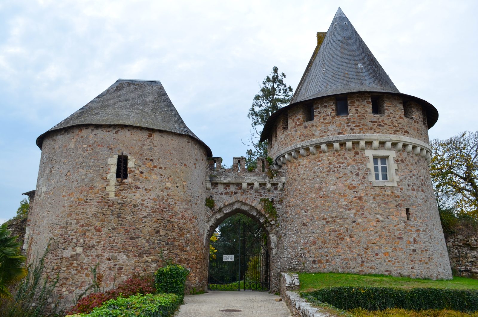
The castle and the fortified town of Champtoceaux are the ruins of a fortress in France in Maine-et-Loire, destroyed in 1420 by order of John V of Brittany. The site was already inhabited in the Neolithic period, and traces of Roman-era structures have been found. A castrum is mentioned there in the 6th century by Gregory of Tours. Champtoceaux, then called Châteauceaux, was located in Brittany in the 10th century on the border of the spheres of influence of the Dukes of Brittany, the Counts of Anjou, and those of Poitou. A fortress was built there, which changed hands many times until the 15th century and suffered nine sieges. John V of Brittany was captured in 1420 as part of a conflict that involved, on the one hand, rivalries between noble families of Brittany, on the other hand, a power struggle between the Kingdom of France and Burgundy, and finally the Hundred Years' War. After his release, John V ordered the complete destruction of Champtoceaux. A new town then developed east of the ruins, whose resettlement was forbidden. These ruins, left in their state, became the subject of historical studies from the 19th century onwards. William Turner made a painting of them in 1826 during his journey along the Loire. The site became a popular walking path and was listed as a historical monument in 2009.
History+
From Castrum to Fortress+
The site is first mentioned in the 6th century by Gregory of Tours in his Historia Francorum, who records a castrum there, but its settlement is much older (polished and worked stones have been found on the site). According to Paul Godet, the etymology refers to Castrum Celsum, translated as Châteauceaux. In his Histoire ecclésiastique de Bretagne, Gilles Deric states that Châteauceaux was Christianized by Saint Méen at the beginning of the 7th century. Robert Favreau, however, points out that around 560, Duke Austrapius was consecrated bishop in Châteauceaux, which temporarily became the seat of a bishopric separated from the diocese of Poitiers.
According to the chroniclers Eginhard and Fredegar, Pippin the Younger is said to have stayed in this fortress of Brittany, which faces Oudon and Ancenis. In particular, he is said to have been present there at Easter celebrations with his wife Bertrada and to have received the ambassadors of Almanzor, Caliph of Baghdad. Champtoceaux was later located on the border of the spheres of influence of the Dukes of Brittany, the Counts of Anjou, and those of Poitou, and already experienced a turbulent history in the 10th century. Eble Manzer, Count of Poitiers, ceded the town to the Normans who occupied the mouth of the Loire. In 938, Alain Barbetorte was recognized as "Brittonum dux" after expelling the Normans from the Nantes region. William I Longsword, son of Eble Manzer, gave him the town as an annuity. The fortress was built at the end of the 10th century: in 986, Renaud of Thuringia, Viscount of Anjou, asked Guérech, Count of Nantes, for permission to build a fortress in Champtoceaux on the ruins of the castrum. He refused him, but Renaud of Thuringia proceeded with the support of Fulk Nerra. In the middle of the 11th century, Champtoceaux belonged to two brothers, Geoffroy and Odéric/Orry of Champtoceaux. In 1044, Geoffroy of Champtoceaux donated the church of Saint-Jean-Baptiste to the Abbey of Marmoutier, which made it a priory, a donation confirmed by the Count of Anjou, Geoffrey Martel, proof that Champtoceaux had moved out of the sphere of influence of the Counts of Nantes. Around 1060, the town had Thibaud of Jarzé, son-in-law of Orry of Champtoceaux, as its lord. Through the remarriage of his granddaughter Narmaise of Jarzé, Champtoceaux passed into the hands of the Crespin, a Norman family connected to the English court, in the 12th century. The town was then involved in the struggles between the Plantagenets and the Capetians.
A Town That Changes Hands+
Champtoceaux suffered nine sieges from the 12th to the 15th century and frequently changed hands. The first siege of the fortress is said to have taken place in 1141, as part of a revolt of vassals in Anjou and Normandy against Geoffrey Plantagenet, who besieged and captured Champtoceaux, according to the annals of Saint Aubin and Saint Serge. It was first destroyed in 1172 by Maurice de Craon, seneschal of Henry II Plantagenet, when three of his sons rebelled against their father, supported by the Angevins and the Nantais. The fortress was rebuilt by Geoffroy Crespin. The Moulin-Pendu was built in the following century on the Loire, below the fortified complex, this structure probably also serving as a customs post on the river.
In 1203, Champtoceaux fell into French hands when Philip II Augustus conquered John Lackland's continental possessions to punish him for the murder of his nephew Arthur I of Brittany. Three years later, after John Lackland's landing in La Rochelle to reconquer his lands, Thibaud Crespin, lord of Champtoceaux, joined him. Champtoceaux was recaptured by John Lackland, but he could not hold it. In 1214, according to the chronicler Guillaume le Breton, John Lackland recaptured Champtoceaux again, but the town was recaptured by the French king in the same year. John Lackland gave up, and Thibaut Crespin swore allegiance to the French king. Thibaud Crespin, however, behaved like a robber, plundering and extorting merchants who passed on the Loire at the foot of his fortress. He rebelled with the Poitevin barons against King Louis VIII. Peter I of Brittany, an ally of the king, besieged Champtoceaux, and Thibaud Crespin surrendered on September 21, 1224, and then went into exile in England. The king gave the town to the Duke of Brittany as a thank you, but it remained in the County of Anjou. The inhabitants were exempt from the salt tax, a privilege they retained until the Revolution. Peter I strengthened the defenses of the fortress. Five years later, taking advantage of the youth of the French King Louis IX, who was only fifteen years old, he paid homage to the English King Henry III and allied with him to reconquer the provinces taken from the Plantagenets. According to the chronicle of Guillaume de Nangis, Louis IX led his armies. He besieged Champtoceaux, which capitulated. But Peter I immediately recaptured the town after the dissolution of the French army. In 1234, a new campaign by the French king took place, ending with another surrender of the fortress. The Breton War of Succession (1341-1364) saw the Monfort (supported by the English) and Penthièvre (supported by the French) families dispute the ducal crown. In 1341, the French party conquered the fortress. The town changed hands several times during the conflict: in 1367, the Count of Anjou, according to the provisions of the Treaty of Guérande, which ended the Breton War of Succession, handed over the fortress to John IV, Duke of Brittany, son of John of Montfort. In 1373, John IV had to flee to England after a general uprising. Charles V took the opportunity to introduce his troops into the Duchy under the command of Bertrand du Guesclin. The fortresses of the Duchy, including Champtoceaux, opened to him. In 1377, Champtoceaux was returned to the Count of Anjou, but the second Treaty of Guérande (1380) returned the town to the Duke of Brittany. In 1390, the citadel was sold to Olivier de Clisson.
Destruction by Order of John V of Brittany+
The decisive event in the history of this place took place in 1420. Duke John V and his brother, the Count of Étampes, were invited to Champtoceaux by Marguerite de Clisson, the widowed Countess of Penthièvre, to celebrate Valentine's Day there and finally seal the reconciliation between the Penthièvre and the Montfort. The enmity between the two families was old (Breton War of Succession). Despite the Treaty of Guérande, which had established the rules of succession, the Penthièvre family had not given up their claims to the Duchy. The two eldest sons of Marguerite de Clisson served in the army of the Dauphin (the later Charles VII). Since John V had joined the Burgundians, the Dauphin is said to have promised the Penthièvre the ducal crown if they captured the Duke. On February 14, John V was captured by Olivier and Charles de Blois, the Countess's sons. He was imprisoned in the second keep of the castle, the so-called Devil's Tower, and threatened with death.
The reaction in Brittany was strong: the Duchy stood united behind Duchess Jeanne de France. According to Paul Godet, an army of 50,000 men was mobilized. This army, supported by English troops, reduced one after another the fortresses of the Penthièvre and besieged Champtoceaux at the end of May, with the town being subjected to incessant artillery fire. The Duke, who had been transferred to Clisson, was released on July 5, and the fortress surrendered. The Parliament of Brittany ordered the confiscation of all the Penthièvre family's property, which was annexed to the ducal domain. John V ordered the complete destruction of the fortified town "to the ground," houses, churches, and walls. The inhabitants had three days to leave the place. The demolition work extended over ten years, as Champtoceaux at that time had an area twice that of Carcassonne. In 1826, William Turner made several drawings and watercolors during his trip on the Loire, depicting the ruins of Champtoceaux and the Moulin-Pendu.
Development of the Site+
The town of Champtoceaux emerged from 1431 southeast of the former fortified complex, which remained largely unoccupied, on the siege ring of 1420. Its history continued to be unstable: John V gave the place to his Marshal of Brittany, Berrand de Dinan, but René of Anjou (youngest son of Louis II) seized the seigneurial revenues from 1444 to 1474, thus regaining the old rights of the Angevins. Finally, Louis XI, heir of the Angevins through his mother Marie, seized Champtoceaux and returned it in 1480 to the Penthièvre (Nicole, niece of Olivier de Blois-Penthièvre and granddaughter of Margot de Clisson, and her husband Jean de Brosse de Boussac). The Penthièvre finally ceded the town to the Constable of Montmorency. Through marriage, it fell to the Princes of Condé, who controlled it until the Revolution. The rebuilt priory of Saint Jean-Baptiste was then destroyed. In the 18th century, Champtoceaux was annexed to the diocese of Nantes, but administered by a seneschal under the Présidial of Angers. A castle, the Château de la Colinière, was built in the 19th century north of the former farmyard and redesigned in the 19th century with a central pavilion with a belvedere. Near the castle is a vaulted cave about fifteen meters long, which continues into three small chambers. Located northeast of the esplanade, the former priory of Saint Jean-Baptiste, rebuilt after the siege of 1420, shows significant remains that seem to date from the end of the 15th or beginning of the 16th century. It is known that there was also a parish church dedicated to Saint Mary Magdalene, which Abbot Boutin located on his 1913 plan between the hill and the Bayle ditch.
Description of the Remains+
The peculiarity of the Champtoceaux site is that the remains of a fortified town and a medieval castle have been preserved in their original state after their destruction, so that very few later settlements and reconstructions have disturbed the archaeological remains. The former fortified town and the ruins of the castle occupy an area of about twenty hectares. The site is bounded to the north by the Loire and to the south by the Voinard stream. According to old descriptions, this was supposed to feed a pond that bounded the fortress to the south. It is an easily defensible site: only the east of the plateau is without natural defenses. On this side, it extends gently sloping to the site of the present town, while the other sides have a steep slope (up to 70 meters drop), with the northern flank being the steepest. A large ditch had been dug at the foot of the walls to the east, south, and southwest. The top of the hill is divided into three enclosures surrounded by ramparts (about 2300 meters of walls and 14 towers). To the east, the castle settlement occupies about 9.5 hectares. At its western end, it is separated from the Bayle or farmyard (1.2 ha) by a double ditch. After another ditch, the west of the spur is occupied by the castle (1.33 ha). The heavily ruined ensemble is overgrown with vegetation and retains no traces of its defensive crowns, which makes dating the remains difficult.
The Castle+
The castle is connected to the Bayle by a two-towered entrance gate at the northeast corner. A bridge pier is still in the middle of the ditch. The rampart is preserved up to two meters high on the north side. On the other sides, it is reduced to its foundations. Two mottes are located within the castle's defensive perimeter. The larger one, in the northeast, bears the remains of a strong tower and traces of ramparts. The second, at the western end of the spur, is separated from the rest of the castle by a ditch and bears the foundations of a keep. There are also the remains of the castle chapel of Saint-Pierre, two buildings, one to the east and one to the south, a staircase leading to the keep, and a cistern. There is an underground passage that opens to the surface through two collapses, and its significance could not be determined due to the risk of collapse.
The Bayle or Farmyard+
The farmyard is inclined and lower than the plateau once occupied by the town, from which it is separated by a double ditch, whose central slope bears wall remains. The base of the two towers of the entrance gate to the town, to the north, is preserved.
The Castle Settlement+
The gate facing the town is the most visible element of the fortress, but it does not do it justice: it preserves nothing of its original installations except its foundations, as it has been completely fantastically and unconvincingly rebuilt. On old cadastres, a path existed on the southwestern flank of the hill, which possibly corresponded to another access gate to the settlement or to the Bayle. On the east and south sides, the rampart is preserved up to 5 meters high. On the north side, it is more difficult to recognize. A hill surrounded by a partially filled ditch rises west of the plateau, near the Bayle ditch. The Château de la Colinière was built in the 17th century and redesigned in the 19th century with a central pavilion with a belvedere. Near the castle is a vaulted cave about fifteen meters long, which continues into three small chambers. Located northeast of the esplanade, the former priory of Saint Jean-Baptiste, rebuilt after the siege of 1420, shows significant remains that seem to date from the end of the 15th or beginning of the 16th century. It is known that there was also a parish church dedicated to Saint Mary Magdalene, which Abbot Boutin located on his 1913 plan between the hill and the Bayle ditch.
Take Mobile History with you
You are reading this text for free. Premium adds what matters on the road: descriptions read aloud, sites found through your camera, whole regions taken offline.
- Every description, including the ~17,700 Premium sites
- Audio guide: have descriptions read to you on location
- AR finder: see sites through your camera, with distance and bearing
- Unlimited saved sites
14 days free, then from €2.99 a month. Cancel anytime.
Source: Wikipedia · Licence: CC BY-SA 4.0 · Image: Selbymay · Wikimedia Commons · CC BY-SA 3.0
This description is a machine translation of an excerpt from the linked Wikipedia article. The source text was written by its authors, the translation is by Mobile History; like the original it is licensed under CC BY-SA 4.0.
Location: 47.3373, -1.2704