The remains of the Castle can be visited
CastleChamaret
Château de Chamaret
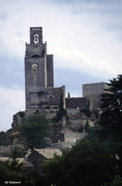
In the municipality of Chamaret, in the Drôme department, Rhône-Alpes region, France, is the castle ruin of Château de Chamaret. The site dates back to the 12th century.
History+
The origins of the Château de Chamaret date back to 1136, when Dodon I of Chamaret began constructing a feudal fortress, completed in 1157 under Dodon II. Following an inheritance division in 1254, Amalric of Chamaret, from a younger lineage, built his own keep, now known as “Le Pigeonnier”. At this time, two brothers shared dominion over the fortress. Amalric submitted to the Bishop of Saint-Paul-Trois-Châteaux, while his elder brother remained independent until he was subjugated by the Adhémar in 1255. Consequently, the Bishop and the Adhémar shared suzerainty, and a wall was erected between the two towers. In 1506, the Adhémar family gained full possession of Chamaret and converted the south tower into a dovecote. The complex was repeatedly affected during the Wars of Religion and frequently changed hands. Parts of the northern castle collapsed in 1696 and again during the 1772 earthquake, but the main tower withstood. In the 19th century, the site served as a quarry for villagers. A partial restoration of the tower and the rock platform took place between 1894 and 1895 thanks to a legacy, including the installation of a bell. Archaeological investigations were carried out after its inclusion in the supplementary inventory of historical monuments in 1992.
Location+
The castle ruin of Château de Chamaret is situated at an elevation of approximately 204 meters above sea level.
On site+
Today, only remnants of the two fortifications, the keep, and two residential buildings of the Château de Chamaret remain. The square tower, interpreted as a signal tower, is the best-preserved part and offers extensive views from its summit. The castle ruin is accessible to visitors.
Take Mobile History with you
You are reading this text for free. Premium adds what matters on the road: descriptions read aloud, sites found through your camera, whole regions taken offline.
- Every description, including the ~17,700 Premium sites
- Audio guide: have descriptions read to you on location
- AR finder: see sites through your camera, with distance and bearing
- Unlimited saved sites
14 days free, then from €2.99 a month. Cancel anytime.
Source: Wikipedia · Licence: CC BY-SA 4.0 · Image: Hervé Rebours
This description draws on the facts documented in the linked Wikipedia article; Wikipedia content is licensed under CC BY-SA 4.0. Wording and editing: Mobile History.
Location: 44.3953, 4.8825