The remains of the Castle can be visited
CastleSaint-Sornin
Donjon de Broue
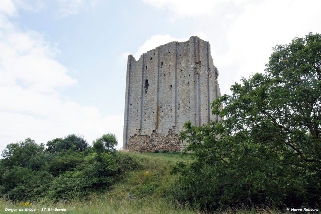
The Donjon de Broue is a castle ruin in the municipality of Saint-Sornin, in the Charente-Maritime department, Poitou-Charentes region, France.
History+
The origins of the Donjon de Broue date back to the 11th century, with its first documented mention in 1047. It is presumed that a wooden tower stood on this strategically important site, which offered a wide view over the then marshlands. The castle played a role in the salt trade, as a navigable arm of the sea at the foot of the rock served as a port for transporting the 'white gold'. The lords of Broue benefited from this trade. Control of Broue changed hands several times, including to the Rochefort, Baussay, and Pons families. With the retreat of the sea and the silting up of the coast in the late 13th and 14th centuries, the port of Broue lost its importance, leading to the decline of the settlement and the keep. Cannon fire during armed conflicts also contributed to its destruction.
On site+
The Donjon de Broue is a freely accessible castle ruin. Primarily the western facade of the former keep remains, still reaching a height of about 25 meters. Details such as pilasters, traces of scaffolding, latrines, and a fireplace are still visible. The keep was designated a historical monument in 1925 and is owned by the municipality of Saint-Sornin.
Take Mobile History with you
You are reading this text for free. Premium adds what matters on the road: descriptions read aloud, sites found through your camera, whole regions taken offline.
- Every description, including the ~17,700 Premium sites
- Audio guide: have descriptions read to you on location
- AR finder: see sites through your camera, with distance and bearing
- Unlimited saved sites
14 days free, then from €2.99 a month. Cancel anytime.
Source: Wikipedia · Licence: CC BY-SA 4.0 · Image: Hervé Rebours
This description draws on the facts documented in the linked Wikipedia article; Wikipedia content is licensed under CC BY-SA 4.0. Wording and editing: Mobile History.
Location: 45.7874, -0.9758