Sperrgebiet
FortressKœnigsmacker
Feste Königsmachern (Kœnigsmacker)
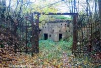
The Feste Königsmachern, also known as Groupe Fortifié de Koenigsmacker, was built after 1908 in the Lorraine region of northeastern France. It is located near the city of Thionville.
History+
Planning for the Feste Königsmachern began in 1900, initially with the construction of an armored battery. Construction officially started on June 28, 1908. By 1910, the facility was approved, and by 1914, it had been expanded into a complete fortress. As part of the Moselle position, its primary task was to protect the course of the Moselle northeast of Thionville, the heights near Cattenom, and the railway connections to Luxembourg and Trier. The fortress included an armored battery with four gun turrets, a central power station for energy supply, several infantry positions with barracks, and an underground tunnel system approximately 1.8 km long. After World War I, the undamaged facility passed to France. In World War II, the fortress was attacked by US troops in November 1944 and captured after several days of fighting.
Location+
The Feste Königsmachern is located in Kœnigsmacker in the Moselle department in the Lorraine region, France, at an altitude of approximately 210 m above sea level.
On site+
The area of the Feste Königsmachern is currently a restricted zone and not accessible to the public.
Take Mobile History with you
You are reading this text for free. Premium adds what matters on the road: descriptions read aloud, sites found through your camera, whole regions taken offline.
- Every description, including the ~17,700 Premium sites
- Audio guide: have descriptions read to you on location
- AR finder: see sites through your camera, with distance and bearing
- Unlimited saved sites
14 days free, then from €2.99 a month. Cancel anytime.
Location: 49.3797, 6.2578