FortressIngolstadt

Fortress Ingolstadt-Zwischenwerk Nr. 5 Großmehring (Werk 193)
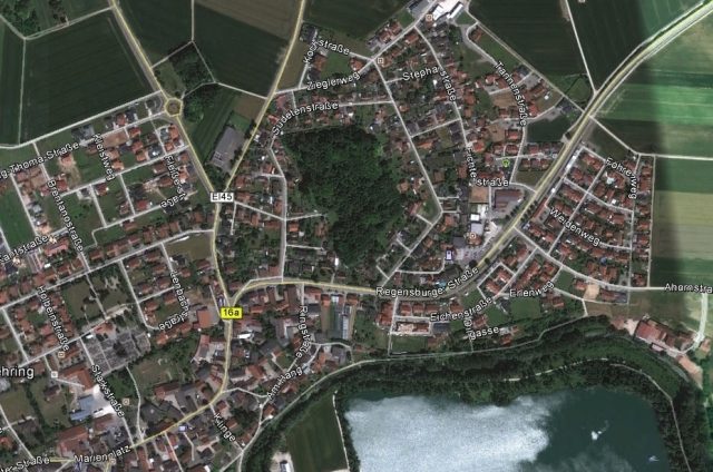
Fortress Ingolstadt-Zwischenwerk Nr. 5 Großmehring (Werk 193)

The Zwischenwerk Nr. 5 Großmehring (Werk 193) is located in the outer fortress ring

The work differed completely from all others. The ditch along the faces and flanks was swept by reverse caponiers connected to the work by underground passages. Another caponier threatened the attacker with flanking fire in the gorge. The work also had more cavities - including a capital postern. The storm-proof nature was increased by a blockhouse at the left shoulder point of the covered way.
Erected between March 23, 1891, and March 22, 1894.

The only fully developed intermediate work with a dry ditch was located near Großmehring. Today, the site is in the middle of the village, on Sudetenstraße, and is privately owned. Some masonry remains and cavities are still present. Due to the dry ditch, the complex was of a special design, completely different from all other intermediate works and forts. The ditch was secured by casemates in the outer wall (the counterscarp). There was a circumferential vaulted passage in the outer wall, and ditch defenses were integrated into the corners. Only the ditch at the rear was secured by a caponier with a connection to the gorge barracks.

State Fortress Ingolstadt+

The State Fortress Ingolstadt was a fortress of the Bavarian Army around Ingolstadt. In the course of the reconstruction of the original medieval fortifications and the subsequent expansion of the State Fortress Ingolstadt, a total of five main phases can be distinguished, which are presented below. It is noteworthy that in Ingolstadt, in addition to the almost completely preserved medieval city wall, the works from the later phases are preserved, if not completely, then at least to a significant extent, thus conveying a vivid impression of how the city was shaped by the fortress works at the respective time. After the post-war thesis that the remaining fortress works should be removed from the cityscape was abandoned, and since then, especially the classical fortress works have been restored and given new uses, it remains to be hoped that this attention will also be extended to the outworks and remaining ruins of the later phases.

The Renaissance Fortress+

Expansion 1537–1572/1573 by Reinhard Graf Solms, Lord of Münzberg (1491–1562)
Due to the strategic importance of Ingolstadt at the crossroads of the roads from Regensburg to Ulm and from Nuremberg/Amberg to Augsburg/Munich, its location on the northwestern border of the duchy, and the necessity of controlling the Danube bridge due to the fact that the nearest bridges in Neuburg, Regensburg, or Passau no longer belonged to the dominion, Duke Wilhelm IV decided from 1537 to expand Ingolstadt into a state fortress. The basic idea was to place a brick earthwork with a ditch in front of the medieval city wall, on which cannons could be placed for defense. At the corner points, brick bastions were erected, which served as reinforcement and allowed the ditch to be swept and the adjacent ramparts to be protected by flanking fire. During this period, the following works were created:

  • Ziegel-Bastei (Brick Bastion), bricked and casemated bastion
  • Harder-Bastei
  • Kugel-Bastei (Ball Bastion)
  • Kreuztor-Bastei (Cross Gate Bastion)
  • Rundell beim Frauenhaus (Rondel at the Women's House)
  • Streichwehr (Rauchloch) (Flanking defense (Smoke Hole))
  • Rundell am Roten Turm (Rondel at the Red Tower)
  • Donaufront (Danube Front)

The brick works of the first three bastions are still preserved today, with the Kugel- and Harderbastei being used. The other works have not survived, but all are documented in Jakob Sandtner's city model of 1572/73.

Expansion and Extension after the Thirty Years' War+

The works of the Renaissance fortress were reinforced after the Thirty Years' War and expanded or rebuilt by Christoph Heidemann between 1654 and 1662. This was despite the fact that Bavaria was completely devastated after the Thirty Years' War, and it would have been understandable if Elector Ferdinand Maria had spent all available funds on the reconstruction of the country, and not on the reinforcement of the most important state fortress. Nevertheless, initially 20,000 guilders were spent from 1651–1653, and then between 1654–1662, the considerable sum of 260,000 guilders was spent on the expansion of the state fortress. The inner ditch wall on the main rampart was raised, and further bastions, separated by a wet ditch, were erected in front of the existing bastions. Because the gates represented a weak point in every fortress, Heidemann enforced the closure of the Hardertor in the north of the city. The new works were (starting from the east, counter-clockwise):

  • Esel-Bastion (Donkey Bastion) (in front of the already existing work, the so-called "Esel-Kavalier")
  • Feldkirchner Ravelin in front of the Rossmühle, over which the path led over two bridges to Feldkirchen
  • Eiskeller-Bastion (Ice Cellar Bastion) in front of the Feldkirchner Tor
  • Sebastians-Bastion (named after the nearby St. Sebastian Church)
  • Ziegel-Bastion (Brick Bastion) (in front of the Ziegel-Bastei, which was now called "Ziegel-Kavalier") with a brick scarp and gorge
  • Lange Kurtinen-Bastion (Long Curtain Bastion) (in front of the main rampart, between Harder- and Ziegelbastei)
  • Harder-Bastion (in front of the Harder-Bastei, now "Harder-Kavalier", the Hardertor was walled up and the gate tower demolished)
  • Kugel-Bastion (Ball Bastion) (in front of the Kugelbastei, now also renamed "Kugel-Kavalier")
  • Kreuztor-Bastion (Cross Gate Bastion) (in front of the rondel at the Kreuztor, which became the "Kreuztor-Kavalier")
  • Frauen-Bastion (Women's Bastion) in front of the rondel at the Frauenhaus
  • Rauchloch-Bastion (Smoke Hole Bastion)
  • Münzberg-Bastion (in front of the rondel at the red tower, now "Münzberg-Kavalier" and the weir located there, which was intended to prevent strong outflow from the ditches during low water levels of the Danube)
  • Donaufront (Danube Front) (the earthwork built during the Thirty Years' War up to the Herzogskasten was extended to the New Palace)
  • Brückenkopf (Bridgehead) (executed as a hornwork with the so-called "Hornwerk-Lünette")

During the War of the Spanish Succession, Ingolstadt was besieged in 1704 by troops of Margrave Ludwig of Baden, but the siege was lifted due to the enemy's victory at Höchstädt, as the troops were needed for the occupation of Ulm. In 1745, during the War of the Austrian Succession, a mock siege by imperial troops took place, during which the then predominantly French garrison of Ingolstadt Fortress under General Grandville surrendered without necessity, whereupon the enemy not only gained the fortress but also 115 cannons and over 10,000 rifles. The condition of the fortress steadily deteriorated under Elector Karl Theodor, as no funds were available for its maintenance. From 1796, imperial troops formed the garrison of the fortress, which was surrendered without a fight to Napoleon's troops in 1800 after the armistice of Hohenlinden; these troops carried out the destruction of the fortress from November 1800 to March 1801. No structural evidence of the buildings erected during the Baroque period has survived.

The Classical Fortress+

Only a few years after the fortress had been razed under Napoleon, the reconstruction of the so-called classical fortress began from 1828–1849, initially by Michael von Streiter (1773–1838) in collaboration with Leo von Klenze, later by Peter von Becker (1778–1848).

Through funds saved by the military savings commission in the military budget, Ludwig I found himself able in 1826 to rebuild the fortress works destroyed by the French in 1801.

Ludwig I, against the fortress construction commission, which favored Regensburg, as well as against Commander-in-Chief Wrede, who favored Germersheim, designated Ingolstadt as the location for the new royal Bavarian main state fortress. The decisions and implementation of the works began over the heads of Wrede and War Minister Mailot. The decision was not unreasonable, as Ingolstadt was now almost in the geographical center of the new kingdom and, moreover, an attack was to be expected from both French and Austrian sides.

Work began in 1828 with the laying of the foundation stone at the bridgehead for the Reduit Tilly. At times, up to 7,000 workers were employed in the construction of the fortress. This was against the background that after the razing of the fortress and the departure of the university in 1800, only 4,400 people lived in Ingolstadt in 1818. By 1846, the population, grown by the economic upswing due to the work on the fortifications, had already exceeded 13,000. By 1849, the defensive capability of the fortress could be reported. By 1855, around 23 million guilders had been spent, making the fortress the most expensive construction project of Ludwig I's reign. The fortress buildings at the bridgehead followed Streiter's circular design, while on the northern side of the Danube, Becker's polygonal system was implemented, with the southeastern flank executed only with irregular fronts (along the remains of the fortifications before 1800), and the parts north of the Schutter as regular fronts.

  • Names of the fortifications (fronts and cavaliers alternate)
  • Kavalier Dallwigk, Fronte Raglovic
  • Kavalier Heydeck (with New Feldkirchner Tor), Fronte Rechberg
  • Kavalier Elbracht, Fronte Zoller
  • Kavalier Spreti (with New Hardertor), Fronte Vieregg
  • Kavalier Hepp (with New Kreuztor), Fronte Pappenheim
  • Kavalier Zweibrücken
  • Schutterhof
  • Fronte Butler, Turm Baur (original designation, not to be confused with today's Turm Baur on the right bank of the Danube)
  • Fronte Preysing, Turm Triva
  • Kehle Deroy
  • Brückenkopfbefestigung Tillyveste (today: Reduit Tilly) with two oval towers (today: Turm Baur and Turm Triva)
  • Fronte Gumppenberg also with a flanking tower

All the cavaliers are preserved except for Kavalier Spreti, which was demolished in 1963. Of the fronts, only Fronte Rechberg and the foundations of Fronte Raglovic are preserved. The bridgehead buildings can be found in today's Klenzepark. In addition, the ditch and wall of the irregular fronts and Fronte Preysing (today Fronte 79) are preserved.

Construction of the First Outwork Belt+

Already in Streiter's first designs for the refortification of Ingolstadt, 4 outworks were planned for the left bank of the Danube at a distance of approx. 600–700 fathoms (1100m) from the main rampart. Streiter assumed that artillery technology would develop rapidly and therefore independent outworks were necessary to effectively prevent a bombardment of the city center. After Streiter's dismissal due to cost overruns (which were ultimately due not only to inaccuracies in calculation for which he was responsible, but also to Klenze's ideas for the execution of the fortress buildings) and the appointment of Colonel Peter Becker as fortress construction director, three outworks (Haslang in the west, Max Emanuel in the north, and Wrede in the east) and two cross blockhouses (Habermann in the northwest and Minucci in the northeast) were now planned. Lack of funds and the rapid development of artillery delayed the construction of the outworks. Although the land acquisition for the outworks had already taken place in 1835 and the two cross blockhouses, begun in 1837, had long been completed, planning for the three outworks on the left bank of the Danube was only resumed in 1859. Due to the increased range of the cannons, the planned location of the northern outwork Max Emanuel was moved further from the main rampart and placed on the Ettinger Höhe. After further back and forth, with the high construction costs and lack of funds continuing to be decisive for the delays, the construction of the outworks gained new urgency due to the mobilization order of May 10, 1866. Thus, due to the impending danger of war, the construction of the three missing outer forts and seven further outworks on the right bank of the Danube was carried out in a temporary construction method (earth and wood) between 1866 and 1871. Only the three outworks on the left bank of the Danube were subsequently erected as permanent works between 1868 and 1872.

Construction of the Outer Fort Belt+

In the course of improvements in artillery technology and the resulting greater range of shells, the construction of a further outer fort belt became necessary. Work began in 1875, but after a short time, due to the so-called high-explosive shell crisis, new reinforcement measures were already required, which were completed by 1895. In total, seven intermediate works and nine outer forts were built at a distance of five to eight kilometers from the city center, of which today only Fort VI, Prinz Karl near Katharinenberg, remains. It now houses the Ingolstadt Explosive Ordnance Disposal Command.

Take Mobile History with you

You are reading this text for free. Premium adds what matters on the road: descriptions read aloud, sites found through your camera, whole regions taken offline.

  • Every description, including the ~17,700 Premium sites
  • Audio guide: have descriptions read to you on location
  • AR finder: see sites through your camera, with distance and bearing
  • Unlimited saved sites

14 days free, then from €2.99 a month. Cancel anytime.

Source: Wikipedia · Licence: CC BY-SA 4.0

This description draws on the facts documented in the linked Wikipedia article; Wikipedia content is licensed under CC BY-SA 4.0. Wording and editing: Mobile History.

Location: 48.7698, 11.5401