FortressKoblenz-Goldgrube

Fortress Koblenz-Batterie Hübeling
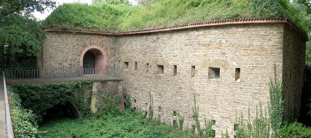
Fortress Koblenz-Batterie Hübeling

The Fortress can be visited

Battery Hübeling was part of the Prussian Fortress of Koblenz and belonged to the Feste Kaiser Alexander system. This so-called intermediate work is now located in the main cemetery in the Goldgrube district of Koblenz. The battery was built to cover the right flank of the Feste Kaiser Alexander and simultaneously secured the blind spot below the fortress. Additionally, it commanded the Moselle and the Moselle river road, as well as the forefield of the Moselweiß Schanze (Fort Blücher). Since the 1950s, Battery Hübeling has been a memorial site for the city of Koblenz for those who fell in the Second World War, featuring a memorial hall.

Battery Hübeling was built between 1828 and 1830 as a defensive powder magazine. It was a small detached work with a casemated blockhouse. This consisted of a brick gun tower with two stories on a slope, located approximately 350 meters below the Feste Kaiser Alexander. The front (battery side) is curved to the south, and the entrance is located on its back on the first floor (battery level). Access was originally via a movable bridge, which was within the firing range of the embrasures and was later replaced by a fixed bridge. The blockhouse is surrounded by a brick ditch, and the earth cover on the roof is approximately 2.5 m thick. It was not intended for peacetime troop occupation. The basement was designed on the front as a gallery with firing openings for mortars. The facility was armed with eight to ten guns and mortars, as well as an infantry detachment in addition to the artillery crew. In 1859, a water pipeline was laid from Saillant IV of the Feste Kaiser Alexander.

The work was abandoned in 1903 along with other parts of the fortress and leased to the city of Koblenz. After the First World War, the Inter-Allied Military Control Commission waived its demolition, as no military use was discernible anymore. The Koblenz Entrenchment Office had previously advocated for the preservation of the facility, among other things, by pointing out that in the event of demolition, the peace of the dead in the neighboring main cemetery would be disturbed.

Memorial Site 1939–1945+

The facility was redesigned into a memorial between 1954 and 1956 according to plans by landscape architect Hans Wilhelm Mutzbauer. The almost completely preserved structure in the west of the main cemetery now houses the memorial for the war dead of the city of Koblenz. Grouped around it are four grave fields with ceramic plates of the fallen in the lawn, interspersed with groups of three short-armed crosses. From the lower main part of the main cemetery, one reaches the memorial site through an archway with a hipped slate roof. The stairs with several landings and block steps were made of red sandstone.

A fixed bridge leads through a sandstone-framed entrance on the west side into the memorial hall. Oak leaves and Iron Crosses are attached to the coffered bronze door. The embrasures were closed with frosted glass panes. The artistic design of the memorial hall was carried out by the painter and sculptor Eugen Keller. He created a bronze angel, pointing with one hand to heaven and with the other hand to earth, which was placed in front of the eastern back wall. On the walls are the names of the fallen from Koblenz and victims of air raids, created by Franziska Plate in fresco technique. A staircase leads to the basement to an empty hall.

Take Mobile History with you

You are reading this text for free. Premium adds what matters on the road: descriptions read aloud, sites found through your camera, whole regions taken offline.

  • Every description, including the ~17,700 Premium sites
  • Audio guide: have descriptions read to you on location
  • AR finder: see sites through your camera, with distance and bearing
  • Unlimited saved sites

14 days free, then from €2.99 a month. Cancel anytime.

Source: Wikipedia · Licence: CC BY-SA 4.0 · Image: http://de.wikipedia.org/wiki/Datei:Batterie_H%C3%BCbeling_Koblenz.jpg

This description draws on the facts documented in the linked Wikipedia article; Wikipedia content is licensed under CC BY-SA 4.0. Wording and editing: Mobile History.

Location: 50.3513, 7.5724