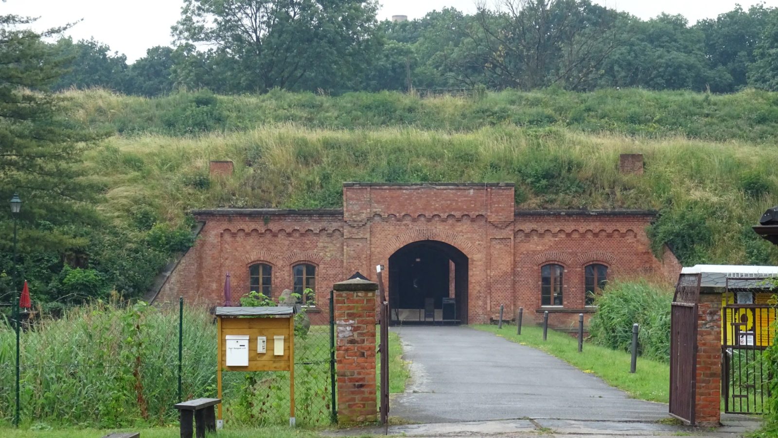
The Fort can be visited
Küstrin Fortress-Fort Gorgast
This site has no photo yet. Sign in to contribute one.
The Küstrin Fortress was a fortress built in the second half of the 16th century to protect the residential city of Küstrin. Its use as a fortress ended only in 1920 as a result of the lost First World War. Shortly thereafter, the demolition of the eastern city walls began. Towards the end of the Second World War, Küstrin was again declared a fortress in 1945, and the city was almost completely destroyed by fighting until the end of March 1945. After the war, the already damaged fortress structures were further destroyed by demolitions and dismantling work for material extraction. Since the 1990s, the fortress facilities in the old town and Fort Gorgast have been undergoing restoration, while the other outer works have fallen into disrepair due to vacancy. A large part of the fortress structures is located on the right bank of the Oder in Polish Kostrzyn nad Odrą, the remaining outer works in the German municipality of Küstriner Vorland.
Before 1535: Prehistory+
The first documented mention of Küstrin dates back to 1232. Küstrin was strategically located at the confluence of the Oder and Warta rivers. To protect the Oder crossing, there was probably a fortification at this location. In 1323, the Ascanian rule ended, and Küstrin changed hands several times until 1455. Then it was sold to Frederick II of Brandenburg and thus belonged to the House of Hohenzollern. In 1535, John of Brandenburg-Küstrin inherited Küstrin among other things and elevated it to his residence.
1535 – 1920: Fortress Status+
Johann began the expansion of his residence with the construction of the castle, which lasted from 1535 to 1537. Subsequently, construction work for the fortress began. The fortifications built from 1537 to 1543 had earthen ramparts, which were repeatedly undermined by floods. After a several-year construction interruption, the ramparts were therefore reinforced with masonry from 1553 to 1568, and the newly erected areas were immediately constructed in masonry. In 1568, the fortress was completed. At that time, it included the bastions König, Königin, Kronprinz, Kronprinzessin, and Philipp, as well as the Berlin Gate and the Zorndorf Gate as city gates. Furthermore, there were the Kietz Gate and the Mill Gate for pedestrian access. Among the fortress builders active in Küstrin in the 16th century were Francesco Chiaramella and, after him, Rochus Graf zu Lynar, to whom the masonry bastions of the city fortifications are attributed.
During the Thirty Years' War (1618–1648), the Swedish King Gustav II Adolf moved south up the Oder from July 1630. By establishing a field fortification on the left bank of the Oder opposite Küstrin, he controlled the Oder crossing and ship traffic. At the urging of the Swedes, Küstrin was handed over to Swedish administration in June 1631. The Swedes immediately began further expansion of the fortress, which was later continued by Elector Frederick William. Between 1631 and 1688, the bridgehead on the left bank of the Oder, the hornwork, and the Brandenburg bastion on the right bank of the Oder between the König and Philipp bastions were built. In addition, the defense of the eastern fortress walls was strengthened by the construction of several redans and the ravelins Gohrin, Albrecht, August-Wilhelm, and Christian Ludwig. A batardeau at the Philipp bastion closed off the moat. Küstrin was now one of the strongest fortresses in Germany.
During the Seven Years' War, Küstrin was besieged by Russian troops from August 15 to 18, 1758, and set on fire. Because it was still largely built of wood, it burned down completely, but without the fortress being captured. King Frederick II relieved the fortress and defeated the Russians on August 25, 1758, east of Küstrin in the Battle of Zorndorf.
As part of the Fourth Coalition War, Küstrin was handed over to Napoleon Bonaparte's French troops in 1806. The takeover occurred almost without a fight, apart from a brief skirmish at the western bridgehead and the destruction of the Oder bridge. The city was occupied by the French until 1814, who continued to expand the fortress. After Napoleon's defeat in the Russian campaign of 1812, the French were pushed back to France in the Wars of Liberation. In March 1813, Küstrin was first shelled by Russian troops. The Lange and Kurze Vorstadt as well as the Kietz on the Oder island were burned down by the French for strategic reasons. Since the fortress could not be stormed, a blockade by Russian, later Prussian, troops followed until the French capitulated in March 1814.
In the 19th century, the fortress was again expanded to protect it against longer-range artillery. On the Oder island, the bridgehead was expanded and supplemented with two flanking lunettes. From 1850 to 1862, lunettes B on the Oder island and lunettes C and D on the left side of the Oder were built. Between 1863 and 1872, the independent Fort "Neues Werk" was built at Küstrin-Neustadt station (today's Kostrzyn station).
In 1877/78, the gatehouses at the Berlin and Zorndorf Gates were demolished and rebuilt as city gates with a double passage. At the same time, the powder towers were removed and replaced by powder magazines outside the city. The road bridges and railway bridges over the Oder and Warta were secured by blockhouses. The construction work concluded with the building of the four outer forts, as Biehler's standard forts: Fort Gorgast and Fort Zorndorf (1882, near Sarbinowo), Fort Säpzig (1887, near Żabice), and Fort Tschernow (1882–1885, near Czarnów). However, these forts were already militarily obsolete upon their completion due to the high-explosive shell crisis, as they could not withstand direct shelling and the range of artillery was so great that direct shelling of Küstrin would have been possible. Outside the city, shortly before the First World War, isolated smaller shelters were still built to allow troops to be deployed flexibly in case of defense.
The fortress facilities significantly hindered the development of the city. Towards the end of the 19th century, however, the facilities became more permeable. The Küstrin Gate was replaced in 1887 by the much wider Küstrin Gate, through which wagons could now also pass. Around 1901, the removal of the Oder ramparts at the castle began. Plans to dismantle the ramparts existed even before the First World War. This could only be implemented years later.
The end of its use as a fortress occurred in 1920, when, by order of the Inter-Allied Military Control Commission, the stationed cannons and weapons had to be withdrawn. Küstrin lost its importance as a garrison due to the personnel restrictions of the Reichswehr.
From 1920: Subsequent Use+
In the interwar period, the fortifications on the east side of the old town were demolished, initially the Zorndorf Gate and the Kronprinzessin Bastion in 1921, and from 1925, the Königin Bastion and the Albrechtstor. At the same time, the moats were filled in so that a new road (today's DK 22) could be routed around the old town. After 1929, the green areas of the Kattewall were created on the ramparts along the Oder. The Casemate Museum was opened in the Philipp Bastion. From 1930 to 1931, the Kronprinz Bastion – also known as Hoher Kavalier – was removed. The outer works were partially rented out and used by various businesses, among others.
At the end of the Second World War, Küstrin was again declared a fortress on January 25, 1945, to halt the advance of the Red Army on Berlin. At the conclusion of their Vistula-Oder Operation, Soviet troops reached the Oder near Küstrin in early February 1945 and established bridgeheads on the western bank. In the battles for the city, which was almost completely destroyed in the process, the fortress was the focal point, falling only at the end of March 1945. The bridgehead near Küstrin became the most important starting point for the Soviet army in the offensive on Berlin on April 16, 1945.
The larger part of the city, formerly located on both sides of the Oder, was annexed to Poland after the end of the Second World War in 1945, while the part of the city area west of the Oder today belongs as the district Küstrin-Kietz to the Brandenburg municipality of Küstriner Vorland. After the war, the outer forts were rendered militarily unusable by Russian troops through partial demolition. Other areas, such as the New Fort, were completely or partially removed for the extraction of building materials. Fort Gorgast was later used by the National People's Army as a warehouse.
Only after 1989 did it become possible to use some fortress structures for tourism. The ruins of the old town and thus also the existing ramparts on the Oder bank between the Berlin Gate and the Küstrin Gate are again accessible. Fort Gorgast can also be visited. The other structures are in a ruinous state.
Fort Gorgast+
Fort Gorgast is located in the village of Gorgast on Federal Highway 1 between Seelow and Küstrin-Kietz.
After the Franco-Prussian War of 1870/1871, fortress construction was intensified in the German Empire. Thus, the Küstrin Fortress was also to receive a strong defensive ring of four forts. In 1883, the Prussian Minister of War Georg von Kameke issued the highest cabinet order for the construction of a fort belt around Küstrin.
Built between 1883 and 1889, Fort Gorgast is the best-preserved outer fort of the former Küstrin Fortress. It was the only fort intended to control the western bank of the Oder and provide a retreat area for troops. The fort was built on farmland from visible bricks and is surrounded by a 42-meter-wide and 3-meter-deep moat. Prisoners from Sonnenburg penitentiary were also used during construction.
It was designed for a garrison of up to 310 men (200 to 300 infantrymen and 60 artillerymen) and consists of single-story visible brick buildings. These include, among others, the so-called blockhouse (with weapon emplacement, the gatehouse with obstacle grid, drawbridge, and guard casemates), the war powder magazine (in the central barracks), barracks, and a well system with an artesian well with a tank, which is still functional today.
The living and working rooms of the fort were equipped with stove heating. Already in 1892 and 1893, the vaulted ceilings of the powder magazine and ammunition magazines were reinforced with a concrete layer. Nevertheless, the fort was already militarily obsolete upon its completion due to the further developed weapon technology (especially in artillery) and changed military strategies, and in the following years and decades, it mainly served as a depot and barracks.
The dismantling of the Küstrin Fortress after the First World War left the fort undamaged. Even at the end of the Second World War, Fort Gorgast, which was used as an auxiliary hospital at the time, was not destroyed despite the heaviest fighting for the Seelow Heights in spring 1945. The fort was occupied by the Red Army, which destroyed parts of the fort by demolition after 1945.
Initially, the Red Army used Fort Gorgast before it was later handed over to the NVA of the GDR for use, which used it, among other things, as an ammunition depot. After German reunification, the fort became the property of the municipality of Gorgast, which, together with a support association, strives for the preservation and monument-appropriate use of the fortress complex. Since September 9, 1997, Fort Gorgast has been a protected monument.
Fort Gorgast can be visited all year round from Monday to Friday from 10:00 AM to 4:00 PM, and from May to October additionally on Saturday and Sunday from 10:00 AM to 4:00 PM. Guided tours are always possible by prior arrangement, regardless of the number of people.
Take Mobile History with you
You are reading this text for free. Premium adds what matters on the road: descriptions read aloud, sites found through your camera, whole regions taken offline.
- Every description, including the ~17,700 Premium sites
- Audio guide: have descriptions read to you on location
- AR finder: see sites through your camera, with distance and bearing
- Unlimited saved sites
14 days free, then from €2.99 a month. Cancel anytime.
Source: Wikipedia · Licence: CC BY-SA 4.0
This description draws on the facts documented in the linked Wikipedia article; Wikipedia content is licensed under CC BY-SA 4.0. Wording and editing: Mobile History.
Location: 52.5603, 14.5448