FortressMainz

Fortress Mainz-Fort Josef
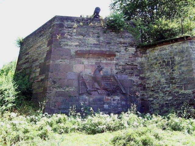
Fortress Mainz-Fort Josef

The Fort can be visited

Fort Joseph, also known as Josephsschanze, was part of the second ring of fortifications of baroque Mainz, the capital of the territory of Electoral Mainz administered by the Electors and Archbishops in the Holy Roman Empire.

The Josephsschanze was built to the right in front of the Gautor on the height of the Linsenberg, where one descends into the Zaybach valley to the pillars of the Roman aqueduct, next to the former Roman military road that led from the Porta praetoria of the castrum. It lies opposite the main stone and is separated from it only by the imagined valley. It extends to the edge of the hill and had two lunettes positioned one in front of the other. With the main stone, it was able to cover the entire Bingerstraße and the so-called Dalheimer Grund, extending beyond Zahlbach.

The still visible pointed stone walls of the remains of the fort, to which the flanks connected at the rear on both sides, are today bordered by Langenbeckstraße and Czernyweg in Mainz-Oberstadt, which lead to the University Medical Center of Johannes Gutenberg University Mainz.

Fort Joseph was built between May 1713 and 1730 according to plans by the fortress builder Johann Maximilian von Welsch on behalf of Elector Lothar Franz von Schönborn, to protect Mainz's interests on the Rhine. Twenty years earlier, the fortress had been liberated from French occupation by an imperial liberation army under the command of Duke Charles Alexander of Lorraine on September 8, 1689, after a three-month siege and bombardment of the city and ramparts.

Now, five new forts were to contribute to strengthening the fortress of Mainz, because with the modernization of weapon technology, cannons now had such a range that enemy troops could simply shoot over the Schönborn bastions of the first ring of fortifications. Fort Joseph, along with the four other detached forts, was intended to better relieve the 16 old bastions to the west. Welsch was supported by Lieutenant Colonel of Engineers Luttig, Colonel of Engineers Gerhard Cornelius von Walrave, and other engineer officers.

Forts and Redoubts of the Complex+

The Karlsschanze [Fort Karl] was located above the former pleasure palace Favorite, today's city park, near the former Neutor. Crenellated masonry with ditches and a parapet connected the Karlsschanze with Fort Welsch, also called the "Welsch redoubt," built under Elector Philipp Karl. Similarly, the Elisabethenschanze [Fort Elisabeth] was connected to the Philippsschanze [Fort Philipp] by a crenellated wall. Between Forts Philipp and Elisabeth ran the chaussée to Nieder-Olm, and to the right in front of Fort Philipp, a dirt road ran to Zahlbach. The double tenaille - "la double Tenaille" - with its three ravelins in front, formed a tenaille system connecting Forts Elisabeth and Joseph. Fort Joseph had a blockhouse to cover the retirade (Latin-Italian-French: place of retreat) and a large area in front of its tip to cover the so-called "holy valley," which had been used for burials since Roman times and until the 8th century.

The very large fortress significantly burdened the budget of the Electorate. The "Engineer Command," responsible for all the fortifications of the city of Mainz, complained to the electoral administration about the lack of expansion and maintenance measures, which they saw as slowly allowing the facilities to decay. Rudolf Eickemeyer addressed several expert opinions directly to the Elector, pointing out the catastrophic state of the fortifications. When French revolutionary troops approached Mainz in October 1792 under General Adam-Philippe de Custine, this had to be paid for with the renewed loss of the fortress to France.

The remains of Fort Joseph are today a cultural monument in Mainz-Oberstadt.

Take Mobile History with you

You are reading this text for free. Premium adds what matters on the road: descriptions read aloud, sites found through your camera, whole regions taken offline.

  • Every description, including the ~17,700 Premium sites
  • Audio guide: have descriptions read to you on location
  • AR finder: see sites through your camera, with distance and bearing
  • Unlimited saved sites

14 days free, then from €2.99 a month. Cancel anytime.

Source: Wikipedia · Licence: CC BY-SA 4.0 · Image: http://commons.wikimedia.org/wiki/File:Fort_Josef_Mainz_from_NW.jpg

This description draws on the facts documented in the linked Wikipedia article; Wikipedia content is licensed under CC BY-SA 4.0. Wording and editing: Mobile History.

Location: 49.9955, 8.2561