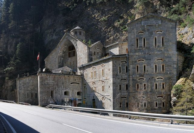
The Fortress can be visited
Nauders Fortresss

The Nauders road barrier, also known as the Hochfinstermünz barrier, is a fortress structure two and a half kilometers northwest of the village of Nauders in North Tyrol. The complex was built between 1834 and 1840 on the site of an old defensive wall and is the oldest manned fortress on the Austrian side during World War I.
Nauders Fortress is located in a gorge in the salient radius of a double curve, making it practically unassailable. It is the only old Austrian fortification from the southern barrier chain that is still on Austrian soil. The work was not involved in combat and is therefore very well preserved. Today, the "Nauders Fortress" museum is located within the fortress.
The structure does not yet show the unadorned simplicity of later years; great importance was still placed on architectural balance here. The geographical conditions were optimally taken into account during construction, with the structure literally nestled against the rock. The complex blocked the road from the Reschen Pass to Landeck and Vorarlberg and Innsbruck. However, its defensive capability extends in two directions, so there was also a field of fire to the north.
The following inscription can be read on the north-facing gable:
- FRANCISCUS I. 1834. FERDINANDUS I. 1840.
This refers to the two Austrian emperors Franz I and Ferdinand I, under whose rule the construction took place.
In accordance with the times, the structure is built of masonry and can only be described as moderately shell-proof. Exceptions are the parts built into the rock, which were therefore considered absolutely bomb-proof. However, direct shelling would not have been possible, and indirect shelling by howitzers from the road over the rock overhangs would probably not have brought much success either.
The work was equipped for rifle and artillery fire and had a gorge ditch with a retractable bridge. A two-story gorge casemate, designed to accommodate eight cannons, is attached to the road.
- First floor: two single casemates on each side. Second floor: one double casemate on each side.
The complex was equipped with eight 8-cm casemate cannons M 94, two of which were transferred to the Gomagoi barrier at the beginning of the war.
The rear part is built high and has up to four stories in places, all equipped with rifle loopholes. Inside are two-story troop casemates and supply rooms. Fresh water was drawn from a stream flowing under the work.
Garrison+
- Detachments of the Landesschützen Regiments Trient No. I and Innichen No. III
- 1 Reserve Company of Fortress Artillery Battalion No. 4 (Riva del Garda)
- 1 Detachment of Fortress Artillery Battalion No. 7 (Malé / Val di Sole)
- 1 Detachment of k.k. Standschützen from Landeck
Approximately 40 men in total, who were housed in a barracks building on the opposite side of the road. Whether the barrier was permanently manned is not known, but rather unlikely.
The planning for the construction was carried out by Field Marshal Lieutenant Franz Scholl, who also designed the Fortress of Verona and the Franzensfeste Fortress. The responsible local engineer was Major General Georg Eberle, who was also chief engineer during the construction of the Federal Fortress of Rastatt.
After World War II, the French occupation forces used Nauders as a depot. The Austrian Federal Army then finally abandoned the property as a military object in 1970, but operated extensive bunker systems and barriers (fixed installations) nearby during the era of territorial defense.
Take Mobile History with you
You are reading this text for free. Premium adds what matters on the road: descriptions read aloud, sites found through your camera, whole regions taken offline.
- Every description, including the ~17,700 Premium sites
- Audio guide: have descriptions read to you on location
- AR finder: see sites through your camera, with distance and bearing
- Unlimited saved sites
14 days free, then from €2.99 a month. Cancel anytime.
Source: Wikipedia · Licence: CC BY-SA 4.0 · Image: http://commons.wikimedia.org/wiki/File:Festung_Nauders.jpg?uselang=de
This description draws on the facts documented in the linked Wikipedia article; Wikipedia content is licensed under CC BY-SA 4.0. Wording and editing: Mobile History.
Location: 46.9132, 10.4932