The remains of the fortress can be visited
FortressReutte
Schlosskopf Fortress
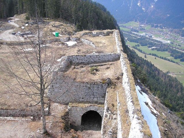
The Schlosskopf Fortress in Tyrol forms a historical fortress ensemble along with the nearby Ehrenberg Castle and other structures. Its location at approximately 1244 meters above sea level made it a stronghold in the region.
History+
As early as 1645, there were initial considerations for fortifying the Hornberg by master builder Elias Gumpp, but these were not implemented. The necessity of such a complex became evident in 1703 during the War of the Spanish Succession, when Bavarian troops invaded. After the hostilities, a provisional guardhouse with palisades was initially erected. The expansion into a fortress began in 1726, but was interrupted. Construction resumed only in 1733 and the fortress was completed in 1741 under the command of Johann Andre von Pach. Despite the construction costs of over three million guilders, the Schlosskopf Fortress was never used militarily. As early as 1782, it was abandoned for military and financial reasons, along with most other Tyrolean fortresses. Subsequently, the complex fell into disrepair as it was sold to private individuals and plundered. It was not until after 2000 that the fortress began to be excavated and renovated, reopening in 2008 as the “Schaufestung Schlosskopf” (Show Fortress Schlosskopf).
On site+
The remains of the fortress are now accessible to visitors. The site has been renovated and designed as a “show fortress” with viewing platforms and towers made of metal construction. A reconstructed tread crane allows visitors to experience historical building techniques.
Take Mobile History with you
You are reading this text for free. Premium adds what matters on the road: descriptions read aloud, sites found through your camera, whole regions taken offline.
- Every description, including the ~17,700 Premium sites
- Audio guide: have descriptions read to you on location
- AR finder: see sites through your camera, with distance and bearing
- Unlimited saved sites
14 days free, then from €2.99 a month. Cancel anytime.
Source: Wikipedia · Licence: CC BY-SA 4.0 · Image: http://commons.wikimedia.org/wiki/File:Festung_Schlosskopf_5.jpg?uselang=de
This description draws on the facts documented in the linked Wikipedia article; Wikipedia content is licensed under CC BY-SA 4.0. Wording and editing: Mobile History.
Location: 47.4638, 10.7105