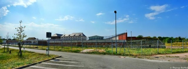
Prison
Festung Torgau-Fort Zinna
The Torgau Fortress developed in the 17th and 18th centuries from an extension of the medieval city wall. In 1811, it was expanded as a Saxon fortress under King Frederick Augustus I at the request of Napoleon Bonaparte. After the end of the Wars of Liberation, Torgau had to be handed over by the Kingdom of Saxony to Prussia in 1815. The fortress was then further expanded as a Prussian fortress until it was abandoned in 1889 and largely demolished in the following decades.
Development+
Prehistory (until 1805)
Since the Middle Ages, the city of Torgau possessed a city wall that encircled the city and ran approximately along the streets Gartenstraße, Rudolf-Breitscheidstraße, and Promenade. Later, the facilities were expanded. A city map from 1650 shows the city wall with a moat. In the north of the city, an outer rampart system with three full and two half bastions, as well as a wet ditch in front of it, is marked. The western bank of the Elbe is additionally protected by two half bastions. On the opposite bank of the Elbe, there is an advanced citadel-shaped bridge redoubt to secure the Elbe bridge. Adjoining this, to protect the south side, is a short rampart with a bastion and moat.
Saxon Elbe and State Fortress (1806–1813)
The Kingdom of Saxony was established in 1806 with the signing of the Peace Treaty of Poznań between France and Saxony and had to join the Confederation of the Rhine. Napoleon Bonaparte demanded that Saxony build a fortress on the Elbe to obtain a military base for his Russian campaign. The cities of Dresden, Wittenberg, and Torgau were examined as possible locations. In 1810, the decision was made to expand Torgau.
In 1811, construction of the fortress facilities began. An earthen rampart with six full and two half bastions was erected around the city. The water in the moat was diverted from the Schwarzer Graben and the Großer Teich, located southwest of Torgau. The areas south of the rampart could also be flooded in the event of an attack (inundation) to make access to the ramparts more difficult. In the northwest, Fort Zinna was built to secure the hill located there, and to its east, Fort Mahla. Furthermore, the eastern end of the Elbe bridge was secured by a new bridgehead and two lateral lunettes.
After Napoleon's defeat in the Russian campaign of 1812, the Wars of Liberation began. The French had to retreat further and further west. In May 1813, the Torgau Fortress was placed under French command. During the subsequent siege of Torgau by Prussian troops, it was forced to capitulate at the end of 1813.
Prussian Fortress (1815–1889)
Through the decisions of the Congress of Vienna, Prussia received the northern part of Saxony in 1815, including Torgau. The fortress was further expanded in the following decades. The existing facilities were primarily reinforced with bomb-proof casemates and reduits to safely accommodate the garrison and equipment during enemy shelling. Counter-mines were laid in Fort Zinna to prevent undermining. Further military buildings such as barracks, provisions, and material depots were built in the city area and in the fortress works. Hartenfels Castle was converted into a defensive barracks. The water management for inundation was further expanded, among other things, to be able to flood the northern areas in front of the rampart. The water level in the moats could be regulated by the construction of a batardeau in front of each outermost half-bastion. The Elbe bridge of the then Halle-Sorau-Guben Railway, which went into operation in 1872, had a fortification on both banks in the form of a blockhouse with an opposite wall and two turrets. The track axis could be blocked by lattice gates.
The further development of artillery, with the impending high-explosive shell crisis, rendered the fortifications of Torgau militarily ineffective. Fort Mahla was already razed in 1878. In 1889, the fortress status was abandoned and the rayon laws were repealed.
Further Development (1889–1989)
After the handover to the city, the fortress works were repurposed or demolished. The earthen ramparts were almost completely removed, and the glacis in front of them on the north and west fronts was converted into a city park. The remaining flank casemates were used by the city administration and commercial enterprises as storage space. The defensive barracks of the bridgehead were used as a Wehrmacht prison Torgau from 1939 to 1945. Fort Zinna was almost continuously a prison, used by various administrations, including as a Wehrmacht prison Torgau and after the end of World War II as Soviet Special Camp No. 8 and No. 10 Torgau. After 1950, Fort Zinna was again a civilian prison of the Volkspolizei.
Current State
Among other things, the following structures of the Torgau Fortress are partially preserved:
- medieval city wall in the area of Gartenstraße,
- the flank casemates of Bastion II, the curtain wall between Bastion II and II including access to the postern, the left flank casemate of Bastion III and the right of Bastion VII,
- the glacis converted into a city park,
- parts of Fort Zinna, today a correctional facility.
- large areas of the bridgehead including the defensive barracks and the moat,
- the Elbe lunettes Werdau and Zwetau,
- the crenellated towers of the railway bridge (the associated blockhouses were only demolished during the new construction of the bridge completed in 1997),
- structures for water regulation, including the remains of the Scheusel lunettes, both batardeaus, and parts of the inundation areas.
Take Mobile History with you
You are reading this text for free. Premium adds what matters on the road: descriptions read aloud, sites found through your camera, whole regions taken offline.
- Every description, including the ~17,700 Premium sites
- Audio guide: have descriptions read to you on location
- AR finder: see sites through your camera, with distance and bearing
- Unlimited saved sites
14 days free, then from €2.99 a month. Cancel anytime.
Source: Wikipedia · Licence: CC BY-SA 4.0 · Image: Thomas Eichler
This description draws on the facts documented in the linked Wikipedia article; Wikipedia content is licensed under CC BY-SA 4.0. Wording and editing: Mobile History.
Location: 51.5648, 12.9813